Great Lakes (North America). lake names
The Great Lakes of North America is a unique natural system consisting of five large lakes connected to each other by rivers and straits. What lakes are honored to be called great, what is the history of their occurrence, and where they are located, we will find out in this article.
General information
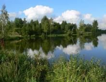
The Great Lakes are located on the territory of two states: Canada and the United States of America. They belong to the Atlantic Ocean basin, and the occupied area is 245.2 thousand square meters. km. with a volume of water 22671 cubic meters. km. This water system includes five major freshwater lakes and numerous very small lakes and rivers.

Rice. 1. Great lakes.
In terms of the size of the occupied area, the Great Lakes surpass even Lake Baikal by about 7.5 times. Despite this, Baikal holds a larger amount of water, which indicates the shallow depth of the Great Lakes. The average depth of Lake Baikal is 744 meters, and the depth of the North American Pearl is 147 meters.
The Great Lakes include:
- Lake Superior;
- Lake Huron;
- Lake Michigan;
- Lake Erie;
- Lake Ontario.
All lakes are interconnected by rivers, canals and straits and together form a unique water system that exists only in North America.
Origin story
The Great Lakes system originates 12 thousand years ago, when the territory of modern North America was covered with ice. Under the influence of tectonic processes, depressions were formed - pits, which gradually filled with fresh water. Where did the water come from? The fact is that the climate gradually changed and the mainland became warmer. The ice melted, and the resulting water filled the depressions, thereby forming lakes.
TOP 3 articleswho read along with this
Lake Superior is the largest lake in the world in terms of area, the rest of the lakes of the studied water system are quite “babies” in comparison with it. It got its name because of its location. It is located 186 meters above sea level. The lake is located simultaneously on the territory of Canada and the United States. The St. Marys River flows out of this lake.

Rice. 2. Lake Superior.
What unites the Canadian province of Ontario and one of the US states of Michigan? Both territories have access to Lake Huron. This lake is unique in that it is connected to Superior, Michigan, and Erie via the St. Marys River, the Strait of Mackinac, and the Detroit River, respectively. The lake is also located in both Canada and the United States.

Rice. 3. Lake Huron.
Lake Michigan
Lake Michigan is the fourth largest freshwater lake in the world. Its peculiarity lies in the fact that it is located exclusively in the United States. All the other "big five" lakes occupy space in both the US and Canada. Scholars often do not separate Huron and Michigan into separate lakes, but treat them as a single entity. After all, they are on the same level and are connected by a deep strait.
In the language of the Indians who originally lived on these lands, the name mishigami is translated as "big water".
Lake Erie
Most of Lake Erie is located in the United States, in Canada it washes the shores of the province of Ontario. It is connected to Lake Ontario by the Niagara River. It is in the bed of this river that the world-famous Niagara Falls is located. Compared to the rest, the lake is not at all deep, the water in it warms up well, which contributes to the reproduction of many species of fish.
Lake Ontario
The last lake in the Great Lakes is Lake Ontario. It is the smallest in this water system. Its area is 20 thousand sq. km. It is connected to the Atlantic Ocean by the St. Lawrence River. Since the Atlantic Ocean is very close, the water in the lake almost never freezes.
The largest system of freshwater lakes in the United States and Canada is represented by 5 closely interconnected huge reservoirs that occupy an area of 245 thousand km2 (water volume 23 thousand km3). The lakes are located in a stepped order from Lake Superior to Lakes Huron, Michigan, Erie, Ontario, descending to the Atlantic, and interconnected by a network of small rivers and straits.
See where the Great American Lakes are located on the world map:
Sorry, the map is temporarily unavailable
The most majestic, deepest, coldest and largest among the Great Lakes of North America is Lake Superior. With harsh, almost untouched shores, it impresses with its size - 85 thousand km2 and depth - up to 406 m. Lake Superior is famous for its steep temper, in stormy weather the height of its waves can reach 12 meters. The northern coast has a particularly inaccessible view, where steep slopes are covered with pine forests and lichens.

The second largest among the Great Lakes of the United States and Canada is Lake Huron. It differs from its counterparts in the unusual outlines of the coast. The northern part of Huron is rocky, with steep banks, separated from the main part by Manitoulin Island. There are many rocky islands, rocks and volcanoes in Georgian Bay. In the southern part of the bay, the shore is represented by sandy beaches. In some places you can see 300-meter limestone cliffs, the so-called "Blue Mountains". The lake covers an area of 59 thousand km2, the depth is 228 m.


Lake Michigan will connect with about. Huron is a wide strait, over which rises the longest bridge in the world (8 km). The outlines of the banks of the reservoir are rectilinear. The northern part is wild and uninhabited. The southern part of the coast is densely populated (Chicago). The area of the third largest reservoir of the Great Lakes of North America is 58 thousand km, the depth is 281 m.


Lake Erie is surrounded by more scenic landscapes, revitalized by numerous national parks and reserves. The Point Pele Nature Reserve is one of the unique places on the continent, where vast marshes with a peculiar fauna have been preserved. The southeastern and northern shores are gently sloping and sandy. The south coast is densely populated, there are large industrial cities of the USA: Cleveland, Toledo, Buffalo. The northern Canadian coast is less populated. The deep Niagara River flows out of Lake Erie, on which the 48-meter Niagara Falls is formed. The area of Lake Michigan is 58 thousand km2, the maximum depth is 281 m.

Lake Ontario is the smallest lake in the Great Lakes system. Its area is only 19 thousand km2, but it is quite deep (maximum depth is 244 m). The banks are low and gently sloping, sometimes covered with deciduous forest. Pointed rocks are often found in the southeast. Large cities are located on the northern Canadian coast: Toronto, Hamilton, Ottawa. The region has many national parks in the United States and Canada. The St. Lawrence River flows out of the lake, through which there is a drain from the Great Lakes to the Atlantic.


The Great American Lakes are a system of freshwater lakes in North America, in the United States and Canada. It includes a number of large and medium-sized reservoirs connected by rivers and straits. The area is about 245.2 thousand km2, the volume of water is 22.7 thousand km3. The five largest lakes are the Great American Lakes: Superior, Huron, Michigan, Erie and Ontario. Tectonic processes have the greatest influence on the formation of lake basins. The mass of the glacier pushed through the earth's crust, and after the glacier melted, a slow reverse process began. Shipping and fishing are developed in the Great American Lakes. With the help of canals, a waterway for sea vessels with a length of about 3000 km was formed.
Lakes are one of the largest accumulations of fresh water on Earth, however, even taken all together, they are inferior to Lake Baikal in this indicator. The Great American Lakes are interconnected by rivers and canals, and therefore the water seems to flow from one to another.
Lake Superior is the largest and deepest lake in the American Great Lakes system. It is the largest freshwater lake in the world (82.7 thousand km2). The lake is located on the border of Canada and the United States. Lake Superior is located at an altitude of 183 m above sea level. The maximum depth is 406 m, the volume of water is 11.6 thousand km3. The coastline is indented, there are large bays - Kivino, Whitefish. In the north, the coasts are high (up to 400 m) and rocky, while in the south they are mostly low-lying and sandy.
Lake Huron - located east of Lake Michigan, connected to it by the Strait of Mackinac. The Huron area is about 59.6 thousand km2. The surface height above sea level is about 176 m, the depth is up to 229 m. The states of Michigan and the Canadian province of Ontario have access to the lake. Manitoulin is located on Huron - the largest island in the world, located in a fresh lake. The name of the lake, introduced by the French, comes from the name of the Huron Indian tribe.
Lake Michigan is the only Great Lake that is entirely within the United States. Located south of Lake Superior, connected to Lake Huron by the Mackinac Strait, to the Mississippi River system - the Chicago-Lockport Canal. The area of Michigan is about 57,750 km2, about 500 km long, and about 190 km wide. The surface height above sea level is 177 m, the depth is up to 281 m. It is covered with ice for about four months a year.
Lake Erie. With an area of 25,700 km2, Lake Erie ranks 13th in this parameter among the world's lakes (including the Caspian and Aral Seas). The lake washes the shores of the American states of Ohio, Pennsylvania, New York and the Canadian province of Ontario. Numerous islands are located in the southwestern part of the lake. The water temperature varies from 0-2 degrees in winter to 24 degrees in summer. The coastal part freezes from December to March-April.
Lake Ontario is the lowest in the Great Lakes system.
The area is 19.5 thousand km².
Height above sea level - 75 m.
The length of the coastline is 1146 km.
Length - 311 km.
Width - 85 km.
Maximum depth - 244 m.
Average depth - 86 m.
The Niagara River flows into the lake, and the St. Lawrence River flows out. Shipping channels link Ontario with Lake Erie and the Hudson River. The lake is the 14th largest lake in the world. Ontario has developed shipping.
First of all, lakes are fresh water reserves, fishing, mining, transportation and sources of electricity. These lakes are an important source of water supply, it is no coincidence that large cities and industrial enterprises of the USA and Canada are located on their banks, the center of ferrous metallurgy, automotive, engineering, chemical industries -
Chicago, Detroit, Cleveland, Toronto and others.
Water is used by more than 250 cities in which over 25 million people live. Approximately 18 billion liters of water are taken from the lakes every day. Canada has the largest reserves of fresh water.
The Great American Lakes are also of great interest in terms of fisheries. Although, in general, their productivity is low - 2.5 kg / ha. Commercial fish here are herring, whitefish, pike, American perch, lake trout.
In the lakes, muskrat and nutria, valuable fur animals, take root well. Their main food is aquatic plants, as well as forbs of coastal meadows. The muskrat is harmless for fishing, hunting and agriculture.
Clay, sand, gravel-pebble reflections also accumulate in the lakes, which are used as a building material and for the manufacture of expanded clay, brick and concrete.
GREAT LAKES, the world's largest lake system in eastern North America, in the St. Lawrence River basin. Includes freshwater lakes Superior, Michigan, Huron, Erie, and Ontario (see Table 1). Lake Michigan is entirely located in the USA, along the rest of the lakes and the rivers connecting them there is a border between the USA and Canada, which owns about 1/3 of the water area of the Great Lakes.
The total area of the Great Lakes is 244.8 thousand km 2, the total volume of water is 22.7 thousand km 3 (21% of the world's surface fresh water). The length of the coastline is over 15 thousand km. The lakes are interconnected by short, rapids and high-water rivers: the Upper and Huron - by the St. Marys River (length 112 km); Huron and Erie - by the St. Clair River (43 km), through Lake St. Clair (area 1275 km 2) and the Detroit River (51 km); Erie and Ontario - by the Niagara River (54 km), forming Niagara Falls. From Michigan to Huron, water enters through the Strait of Mackinac, about 3 km wide. Several hundred small rivers flow into the Great Lakes with a total catchment area of 525 thousand km 2, the largest are Eskanoba, Kalamazoo, Grand River, Muskegon, Manisti, O-Sable, Saginaw, Momi. The flow of lake water masses (210 km 3 / year) occurs along the St. Lawrence River flowing from Ontario, it is regulated by the Irokua hydroelectric complex, located between its source and the mouth of its largest tributary, the Ottawa River.

The basins of the Great Lakes arose as a result of tectonic movements, pre-glacial river and glacial erosion. The bowls of Lake Superior and the northern part of Lake Huron are worked out in crystalline rocks of the southern edge of the Canadian Shield of the North American Platform, the rest of the lakes - in the thickness of Paleozoic limestones, dolomites and sandstones of the platform cover. After the reduction of the ice sheet, the steep banks were transformed by wave abrasion. Beaches, boulder and gravel-sand spits were formed along the shallow and protected from waves areas of the coast. In the northern part of the Great Lakes, the coastline is dissected, the shores (up to 400 m high) are rocky, steep, very picturesque, especially Lake Superior and Huron. The southern shores are predominantly low, clayey and sandy. The largest island in the entire water area of the Great Lakes is Manitoulin with an area of over 1000 km 2 (Lake Huron).
The climate of the Great Lakes region is temperate continental. The average air temperatures in January on Lake Superior are -8°С, on the south coast of Erie -3°С, in July, respectively, 19 and 22°С. Precipitation is 700-800 mm per year.
In the feeding of Lake Verkhneye, the volume of atmospheric precipitation exceeds the inflow of river waters, therefore its water mass is the least mineralized. In the water balance of other lakes, the role of river runoff and water inflow from the lakes located above is more significant. Evaporation from the surface of the lakes is about 165 km 3 /year (20% less than the flow into the St. Lawrence River). For the last 150 years, the amplitude of water level fluctuations in the Great Lakes has been ± 2 m, its intra-annual fluctuations are no more than 0.3 m due to the regulation of flow by hydroelectric facilities. Surge-induced distortions of the water surface reach 3-4 m (Upper, Michigan). The Great Lakes freeze mainly near the coast (from December - January to March - April). In the central part, due to winter storms, there is no ice cover, only in Ontario, continuous ice cover is occasionally observed. Duration of navigation is 8-9 months a year. Under-ice stratification of the water column is weakly expressed. In spring and autumn, convective mixing of lake waters to the bottom occurs. The average surface water temperature in August is 18-22°C. The waters in the lakes have low salinity (72-232 mg/l) (see table 2).
In Michigan, Upper and Huron, the composition of the most common plankton and benthos species is similar. The phytoplankton is dominated by diatoms, among the semi-submerged macrophytes - reeds, burr reeds, reeds, pits, and from the submerged ones - char and semi-submerged algae. Zooplankton consists mainly of bosmines, daphnia and copepods, zoobenthos - of oligochaetes, mollusks. In Erie and Ontario, phytoplankton is dominated by cyanobacteria, diatoms, green and dinophytic algae, from macrophytes - cattail, urut, pondweed, in zoobenthos - chironomids (bloodworm). In all the Great Lakes there are smelt, yellow perch, shad, lightfin zander, in Huron, Upper and Michigan - coho salmon, chinook salmon, quistivomer char and herring whitefish. On the shores of Lake Superior is Takuamenon Falls State Park; Isle Royale (Upper) - as part of the national park of the same name; between the Upper and Michigan - Senei reserve.
Hydroelectric power plants in the Great Lakes system produce 50 billion kWh of energy per year. The total water consumption from the Great Lakes by the end of the 20th century exceeded 20 km 3 per year. From 40 to 70% of the water taken from the lakes was consumed by thermal power plants and nuclear power plants, from 20 to 48% - by industrial enterprises, 5-9% - by public utilities. From the Buffalo city area, the water of Lake Erie is supplied through the Erie Canal to the Hudson River Basin, to the city of New York. To replenish the water resources of the Great Lakes, a portion of the runoff from the Albany river system (Hudson Bay basin) is transferred to Lake Superior through Lakes Nipigon and Long Lake.
 The Great Lakes are connected to the Mississippi River basin by a system of navigable canals starting at the city of Chicago on Lake Michigan; with the Hudson River - a channel originating from the city of Buffalo on Lake Erie. The St. Lawrence River, along with the Great Lakes, is the most important natural route connecting the interior of the United States and Canada to the Atlantic Ocean. The inland waterway of the Great Lakes is 1870 km due to the presence of lock channels bypassing the rapids on the St. Marys River and Niagara Falls (Welland Channel). After the reconstruction of canals completed in 1959, built to bypass the rapids on the St. Lawrence River, a waterway from the Atlantic Ocean to the Great Lakes was created with a length of 3 thousand km and a depth of at least 8 m, accessible to large sea vessels. The main ports are Duluth, Milwaukee, Chicago, Toledo, Cleveland, Erie, Buffalo (USA), Thunder Bay, Hamilton, Toronto (Canada).
By the middle of the 20th century, a powerful anthropogenic impact led to severe pollution and eutrophication of the Great Lakes (especially in the bays). As a result of the degradation of the ichthyofauna, previously numerous mink and otter populations have almost disappeared from some areas of the coasts of Michigan, Huron, Upper. Fish tissues contain high concentrations of DDT and mercury. Lake Superior was the least affected by anthropogenic impact, retaining its oligotrophic status due to its larger size, slow water exchange and low population density of the catchment (4.5 people / km 2). The water in it is the most transparent (> 10 m), differs in the lowest content of phosphorus available for phytoplankton (<3 мг Р/м 3), низким показателем биомассы фитопланктона - хлорофилла «а» (<0,4 мг/м 3) и наименьшей первичной продукцией органических веществ (0,7 мг С/м 3 в час). Более низкое качество воды - в самом проточном озере Эри из-за меньших размеров и наибольшей нагрузки его эвтрофной экосистемы загрязняющими веществами сточных вод крупных городов. Экосистема Эри испытала сильнейшее эвтрофирование, но и ранее, чем в других озёрах, наступает её оздоровление благодаря запрету сброса в Великие озёра недостаточно очищенных сточных вод и наибольшей проточности. Водные массы Мичигана у южных берегов - мезотрофны, в центральной части - олиготрофны. Видовой состав фитопланктона Гурона характерен для олиготрофных озёр, но воды залива Сагино сильно эвтрофированы. Прибрежные воды Онтарио эвтрофны и мезотрофны. Будучи замыкающим, оно получает биогенные и токсичные вещества из остальных озёр (за последние годы скорость эвтрофирования заметно понизилась). В 1909 году правительства США и Канады подписали соглашения о совместном рациональном использовании водных ресурсов. В последней четверти 20 века работы по улучшению состояния Великих озёр активизировались. Для сохранности олиготрофии Мичигана обработанные сточные воды города Чикаго сбрасывают по судоходному каналу в бассейн реки Миссисипи.
Lit.: World water balance and water resources of the Earth. L., 1974; Biennial report under the Great Lakes water quality agreement of 1978... Wash, a.o., 1982-2004-. Vol. 1-12-; Data book of world lake environments. Otsu, 1988. Vol. 3: Americas; Kondratiev K. Ya., Pozdnyakov DV Ecology of the Great North American Lakes: Problems, Solutions, Prospects // Water Resources. 1993. Vol. 20. No. 1; Edelshtein K. K. Hydrology of the continents. M., 2005.
Great Lake
One of the natural wonders of the North American continent is the Great Lakes. A huge network of freshwater reservoirs, interconnected by rivers and straits, is located on the border of the United States of America and Canada. These are five large lakes - Superior, Michigan, Huron, Erie, Ontario. And the largest of them, and at the same time the largest lake in North America, is Lake Superior. The area of this lake is 82.4 thousand km².
In the language of the Ojibwe Indian tribe, the lake is called Gichigami, which means "big water". This great lake is sung in Longfellow's Song of Hiawatha. Like the entire Great Lakes system, Lake Superior was formed as a result of the melting of glaciers. According to scientists, the basin of the lake was formed during tectonic activity, and 25-30 thousand years ago, glaciers began to melt, which at that time covered this part of the American continent.
Upper Lake

Lake Superior is unique in its nature. It is located quite high above sea level (183 m). Its maximum depth is 406 meters. The upper lake is not protected by mountain ranges, so the winds blowing from the ocean are free to "walk" on the lake. As a result, large waves often form on the surface of the lake, which sometimes lead to the destruction of coastal areas.
Lake Superior is the coldest of the Great Lakes. In summer, the water in the Upper Lake warms up only to 5–12°C. Lake Superior is connected to Lake Huron via the St. Marys River. The lake is fed by rain and rivers flowing into it. Therefore, in winter, the water level in the lake decreases somewhat, because there is little rain at this time.
lake shores

The coastline of the Upper Lake is quite indented. The northern shores of the lake are rocky and high, and can reach a height of up to 400 meters. The southern shores are mostly low and sandy. There are also many islands on Lake Superior, the largest of which are Isle Royal, St. Ignace, Mishipikoten and Apostle.
Incidentally, Lake Superior is