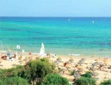
Coastline of the Black Sea. Black Sea
The length of the Black Sea from west to east is 1130 km, the greatest width is 613 km. From the south, the coast of Anatolia (the Asian part of Turkey) juts out into it in a wide arc, and from the north the Crimean peninsula cuts deeply into it. The shores are mountainous almost everywhere, there are few large bays and coves. The largest bays, such as Odessa, Karkinitsky, Tendrovsky, are inscribed in the low steppe shores of the northwestern part of the sea. Some of the bays are fenced off from the sea by wide sand spits - bay bars. The convenient bays of Sevastopol and Balaklava are hidden among the rocks of the mountainous Crimea, and on the Taman Peninsula, shallow bays are overgrown with reeds and reeds (flush). From the east, the Greater Caucasus ranges approach the sea, and even such large cities as Tuapse, Novorossiysk, Batumi have only small bays. A large bay once existed where the largest of the rivers of the Caucasian coast, Rion, flows into the sea. Later, on the site of the bay, the wide Colchis lowland was formed. And from the south, the Pontic mountains approach the sea. On the wide protrusion of Anatolia there are three small peninsulas: lowland Bafra and Charshamba, and mountainous Indzhe-burun with Sinop Bay. The name of this bay recalls the victory of the Russian fleet under the command of P. S. Nakhimov in 1853, during the Crimean War. Less familiar are the names of Turkey's major ports - Zanguldak, Samsun, Trabzon. Giresun, Ordu and the rivers Yeshil-Irmak, Chorokh, Kyzyl-Irmak flowing from its territory into the Black Sea. The Thracian Peninsula (European part of Turkey) has recently been connected to Anatolia by a huge bridge, under which large ocean-going ships can freely pass along the Bosphorus Strait. To the west of this strait, the spurs of the Balkans approach the Black Sea - and here the mountains. The maritime roads of Bulgaria begin from the large ports of Burgas and Varna. Romania is crossed by the Lower Danube Lowland leading to the sea, along the low shore of which a chain of salt lakes stretches. Only the port of Constanta got a convenient bay. The Danube Delta stretches widely at the northern border of Romania. That’s the entire Black Sea coastline of 4090 km. Surrounded on all sides by land, it is one of the inland seas. At the same time, the Black Sea is “assigned” to the Atlantic Ocean basin: it is connected to it through the Marmara and Mediterranean Seas. The area occupied by the Black Sea (423 thousand sq. km) can accommodate two Great Britains. The water surface is only interrupted here and there near the coast by small islands, for example Berezan, located 13 km from Ochakov. Of the few Black Sea islands, the island is the most distant from the coast. Zmeiny (Fndonisi), located 40 km from the Danube Delta.
Compiled by
P. A. Tilba, R. A. Mnatsekanov, V. A. Krutolapov.Geographical coordinates
45°17’34’’ N, 36°45’46’’ EHeight
0-5 m above sea level.Square
38,400 hectares, including water surface: 38,400 hectares.a brief description of
Shallow sea bays, the shores of which are covered with steppe or wetland vegetation.Wetland type
A, E, G, J; predominate: J, A.Ramsar Criteria
4, 5.Criterion 4: The site is one of the wintering centers for waterfowl, the importance of which increases in cold winters when the water area of the estuaries of the Eastern Azov region freezes.
Criterion 5: Up to 1 million birds stop here during migration (Wetlands of Russia, 2000). During mid-winter surveys carried out from the shore using spotting scopes, within the boundaries of the land we counted about 20,000 in 2003, in 2004 - about 10,000, in 2005 - up to 8,000, in 2006 - about 49 500 os. waterfowl and semi-aquatic birds.
Location
Taman Peninsula, southwestern part of the Krasnodar Territory, 30 km from the city of Temryuk.Physiographic characteristics
The site is a low-lying relief that was formed as a result of slow tectonic subsidence of the land, occurring at a rate of 2-5 mm per year (Kanonnikov, 1984). The surface of the coastal land is composed of deltaic and alluvial deposits, under which lie Neogene and Paleogene marine deposits. Bays are permanent bodies of natural origin. The salinity of the water in them reaches 11.3‰, decreasing near the coast to 2-3‰. The depth of the bays ranges from 0.5-2.5 m. The characteristic formations of the Taman and Dinsk bays are lagoons - salt lakes Markitanskoe, Tuzla, etc. In the water area of the bays there are shell-sand islands and spits of various configurations. The Blevako mud volcano is located off the coast of the Chushka Spit in the waters of the Taman Bay.The shores of reservoirs are composed of unstable rocks and are subject to severe destructive activity of the sea. The soil cover is predominantly southern chernozems with a low humus content. The climate type of the site area is coastal-steppe, moderate continental. The average January temperature is −0.8°; July 23.6°C, precipitation during the year is 330-340 mm.
The importance of the land in the natural water cycle
The drainage basin of the site is a hilly plain formed by marine sediments. The hills (reaching a maximum height of 164 m above sea level) are active or extinct mud volcanoes. The soil cover is represented mainly by chernozems, including their solonetzic and saline varieties; thick chestnut soils are also found. Main types of land use: field farming, vegetable growing, viticulture, livestock farming. The climate is moderate continental.Environmental parameters
Along the shores of the bays there are communities of psammophilic and hydrophilic vegetation. Coastal shallow waters, shell spits, and islands are extremely important for the existence of waterfowl.Valuable flora
One of the most widespread plant communities on the site is psammophilous vegetation. In floristic terms, this is the best preserved natural ecosystem, both in the coastal part of the Taman and Dinsky bays, and in Taman as a whole. Typical species on the coastal sands are sandy grate, common sea mustard, hogweed, Pontic katran, naked licorice, gorse-leaved toadflax and others. Of the halophytes on the coastal sand-shell dunes, white sweet clover, entangled and creeping sweda, solifa and tragus, Meyer's kermek, etc. are widespread.And on wet salt marshes there are bluegrass-wheatgrass, rush-sedge and saltwort associations. The vegetation of reservoirs is formed from plant species immersed in water: hygrophytes, hydrophytes and hydatophytes. Phytocenoses of eelgrass and eelgrass are widespread, often forming pure groups over large areas. An equally common species is the holly pondweed. Two types of uruti grow in the reservoirs of the area: spiked urut and whorled urut. In some coastal areas there is typical floodplain vegetation with the presence of common reed, cattails, and sedges (Tilba, Nagalevsky, 1996).
Valuable fauna
The role of the area as a nesting site for birds. The site has a certain significance as a place of reproduction of semi-aquatic bird species listed in the Red Books of the Russian Federation and the Krasnodar Territory: shelduck, oystercatcher (subspecies Haematopus ostralegus longipes), sea plover, little tern. On the territory of the islands there are colonies of great cormorant with a total number of 750 pairs, common tern - 300 pairs, and spotted tern - 300 pairs.The role of the area as a place of bird migration. The site is located on an intensive bird migration route running along the coasts of the Azov and Black Seas. Within the Temryuksky and Dinsky bays, autumn concentrations of laughing gulls, black-headed gulls, and red herons were noted (Vinokurov, 1965). In the fall of 1995, 200 thousand wasps were counted here. coots, 54 thousand - mallards, 200 thousand - red-headed ducks, 1.5 thousand - mute swan (Vinogradov, 2000). The site is a stopover site and large concentrations of migratory waders: Turukhtan, turnstone, grasshopper, etc.
The role of the area as a wintering site for birds. The site is a traditional wintering site, primarily for waterfowl. Between 1967 and 1972. there were from 6 thousand to 250 thousand wasps here. Recently, there have been up to 48.5 thousand waterfowl within the area
(2006 data).
Swans. Mute swan and whooper swan are found in the wintering grounds. The latter species predominates in numbers in colder winters (1,500 were counted in 2003).
Ducks. The most numerous wintering species is the tufted duck (according to 2003 data - 11,500 individuals). In warmer winters, the number of tufted ducks is significantly lower. Of the other duck species, the most common are mallard and red-headed duck.
Other types of waterfowl. The most characteristic species include the great grebe, great cormorant, coot, and laughing gull.
Waders. On the territory of the site in winter, the following were recorded: herbal, great snail, middle curlew, great curlew, snipe, dunlin, on the adjacent territory of the coast of the Kerch Strait of the Chushka Spit, an oystercatcher was recorded during the wintering (Mnatsekanov et al., 2004b; Dinkevich et al., 2005).
The role of the area as a habitat for rare and vulnerable bird species.
Black-throated loon. A common species during the migration period, found in small numbers during the winter.
White-tailed eagle. Regularly wintering species.
Demoiselle crane. Breeding species of adjacent territories.
Bustard. Breeding species of adjacent territories.
Little Bustard. It was observed in winter in the coastal part of the site.
Oystercatcher. Common breeding species; rare, irregularly wintering species.
Great curlew. Not numerous, regularly found in winter.
Black-headed gull. Occasionally observed in winter.
The role of the area as a habitat for marine mammals. The Taman and partly Dinskaya bays are the habitat of the Black Sea bottlenose dolphin, a subspecies listed in the Red Books of the Russian Federation and the Krasnodar Territory.
Social and cultural significance of the site
Within the boundaries of the site there are the most valuable historical and archaeological monuments associated with the Tmutarakan principality of the 11th-12th centuries. In addition, on the site there is a house-museum of M. Yu. Lermontov.Forms of land ownership
State.Land use
The main activity on the site is fishing; In the surrounding area there is winemaking.Factors negatively affecting the condition of the land
Expansion of the area for the construction of the Port Kavkaz port.Environmental measures taken
Part of the site is part of the Zaporozhye-Taman Zoological Reserve. By Order of the Government of the Russian Federation dated April 12, 1996 No. 591-r, the reserve (the order gives the name “Tamano-Zaporozhye Reserve”) is classified as a specially protected natural area of federal subordination. According to the Regulations of the reserve, its area is 30,000 hectares.Proposed environmental measures
Resolving the issue of the status of the reserve. Adjustment of the Regulations on the reserve taking into account the importance of the territory as a mass wintering site for shorebirds, including rare species, as well as a nesting site for rare bird species. Giving the status of a Ramsar site to the entire water area of the Taman and Dinsk bays.Scientific research
Scientific research within the site has been and is being carried out in the course of studying the biota of the Taman Peninsula as a whole. In addition, in recent years, special mid-winter censuses of waterfowl have been conducted here as part of the Wetlands International project on the Central Asian Flyway, funded by the Ministry of Agriculture, Nature and Food of the Netherlands.Environmental education
Not currently available. There are good opportunities for organizing observations of migrating and wintering birds.Recreation and tourism
The site is intensively used for tourism purposes, mainly for historical and cultural reasons. Recreational pressures on plant and animal habitats are low.Jurisdiction
Administration of the Temryuk district of the Krasnodar region.Site management body
The Tamano-Zaporozhye Nature Reserve is departmentally subordinate to the Office of the Federal Service for Veterinary and Phytosanitary Surveillance in the Krasnodar Territory and the Republic of Adygea.Located in the depths of the continent, the Black Sea is the most isolated part of the World Ocean. In the southwest it communicates with the Sea of Marmara through the Bosphorus Strait, the border between the seas runs along the line Cape Rumeli - Cape Anadolu. The Kerch Strait connects Chernoye and.
The area of the Black Sea is 422 thousand km2, volume - 555 thousand km3, average depth - 1315 m, greatest depth - 2210 m.
The coastline, with the exception of the north and northwest, is slightly indented. The eastern and southern shores are steep and mountainous, the western and northwestern shores are low and flat, steep in places. The only large peninsula is Crimean.
The length of the Russian coast of the Black Sea (from the Kerch Strait to the mouth of the Psou River) is about 400 km. The entire region of the Black Sea coast of Russia can be divided into two large regions - Taman and Western Caucasus.
In the northwestern part of the sea there are the largest bays - Karkinitsky, Kalamitsky. In addition to them, on the southern coast of the sea there are Sinop Bay and Samsun Bay, and on the western coast there is Burgas Bay. The small islands of Zmeiny and Berezan are located in the northwestern part of the sea, Kefken - east of the Bosphorus.

I would be grateful if you share this article on social networks:
Length of the Black Sea from west to east - 1167 km, from north to south - 624 km. The greatest depth is 2,212 m, and the average is 1,271 m. The length of the coast along the perimeter is 4,090 km, the length of the coastline reaches 4,340 km. The area of the Black Sea is 423,000 square meters. km.
Due to the excess inflow of fresh water from the rivers Danube, Dniester, Dnieper, Southern Bug, Mzymta, Bzybi, Kodor, Inguri and others. (more than 300 rivers) above evaporation it has less salinity than the Mediterranean Sea. Rivers contribute 346 cubic meters to the sea. km of fresh water and 340 cubic meters. km of salt water flows from the Black Sea through the Bosporus.
Depth of the Black Sea
Black Sea is one of the deepest sedimentary basins in the world. The thickness of sedimentary deposits on the seabed is 14 km. The bottom relief is a deep basin with steep slopes, its maximum depth is up to 2211 m. The area of the Black Sea is 413,488 square meters. km. The maximum length is 1148 km, the maximum width is 615 km, the length of the Black Sea coastline is 4077 km.
The Black Sea washes the shores of Russia, Abkhazia, Georgia, Turkey, Bulgaria, and Ukraine.
There are few bays, bays and peninsulas in the Black Sea and almost no islands. This is due to the constant rise in sea level.
Composition of Black Sea water
Salty taste Sodium chloride gives sea water, and magnesium chloride and magnesium sulfate give it a bitter taste. Water contains 60 different elements. But it is assumed that it contains all the elements found on Earth. Sea water has a number of healing properties. Water salinity is about 18%.
About 87% of the Black Sea water volume is deprived of oxygen and is contaminated with hydrogen sulfide. At a depth of over 150 m, the water contains hydrogen sulfide, and therefore the sea is devoid of living organisms at great depths. The source of hydrogen sulfide is the decomposition of the remains of aquatic organisms; at a depth of 150-200 m, the hydrogen sulfide content reaches 7.5 cubic meters. cm per liter of water, and its total amount is a billion tons. The uniqueness of the Black Sea is that in the deep layers of its water there are no algae, invertebrate animals and fish, there are no living creatures except sulfur bacteria.
Determined that age of the Black Sea about 8 thousand years.


