Black Sea (shores in Russia). How does the Sea of Azov differ from the Black Sea
Is the Black Sea coastline indented or not, what is it like, what features does it have? This question is often asked by students. Let's try together to understand the features of this reservoir and, of course, find answers to the questions posed.
Briefly about the sea
It is more than 420 thousand sq. m. km. In its outline, it is similar to an oval with a length of 580 km in width and 1,150 km in length. The depth is 2210 m in the deepest part of the occupied territory. The Black Sea is one of the inland seas. The connection with the ocean occurs thanks to the Marmara, Mediterranean, and Azov seas. The threads connecting all four water territories are the Bosphorus, Dardanelles and Kerch Straits.
The ruggedness of the Black Sea coastline is weakly expressed. The size of the area occupied by this reservoir is equal to twice the area of Great Britain. Seven countries are washed by the waters of the Black Sea: in the north - Ukraine, in the northeast - Russia and Abkhazia, in the southeast - Georgia, in the south - Turkey, in the northwest - Romania and Bulgaria.
Signs of life are present in it only at a distance of 150-200 m from the surface. Further, the water is saturated with hydrogen sulfide, because of this the development of living organisms is simply impossible. The exception is anaerobic bacteria.
What is the coastline of the Black Sea?
Most of the coastline is more or less flat. Only on the northern side is there a slight ruggedness. The length of the Black Sea coastline is 3,400 km. Crimea is the largest peninsula. On the opposite side, the coast of Anatolia protrudes strongly.
There are many bays in the north; they are somewhat less common in the south and northwest. Also, the Black Sea coastline is represented by estuaries. They are mainly found on the northern and northwestern coasts. On the side of the Crimean peninsula, mountainous terrain is observed.

Bays
The largest bays are in the north. This territory belongs to the state of Ukraine. This position is quite advantageous, and it is determined by the presence of the following bays: Yagorlytsky, Dzharylgachsky, Kalamitsky, etc. But in the southwest there are fewer of them, the largest are: Varna and Burgas (the state of Bulgaria). The Black Sea coastline in the south is also not represented by many bays. The main ones: Sinop and Samsun - belong to Turkey.
Crimea can freely be proud of Sevastopol and which are located between the rocks. The Taman Peninsula is characterized by many small bays where reeds and reeds have found a place to live. The result of this was the formation of floodplains.
Coastline relief
From the north and northwest, due to the inflow of rivers, estuaries are formed. In this part the banks are low. Sometimes you can see cliffs. But the coastline of the Black Sea near the Crimean Peninsula is mountainous. This especially applies to the southern and eastern shores. Here you can already see. Also in this part of the coast are the Caucasus Mountains, which reach right down to the water.

The Great Outcropping of Anatolia is characterized by three small islands. Bafra and Charshamba have a low-lying surface, while Injeburun is mountainous. This also includes Sinop Bay. It received its name in honor of the memory of the victory of the Russian fleet in the Crimean War in 1853. The commander then was P.S. Nakhimov.
Once upon a time, at the entry point of one of the largest rivers, Rion, there was a large bay. Over time, the Colchis Lowland appeared in its place.
On the Turkish side, the Black Sea coastline receives several rivers. These are the Yeshil-Irmak, Choroh, and Kyzyl-Irmak watercourses. On the European side of Turkey is the Thracian Peninsula. Very little time passed when a wide bridge was built to connect it with Anatolia. This allows large ships to easily navigate the Bosphorus Strait. To the west of it they come very close. There are several large ports. One of them is Burgas, the other is Varna. It is from here that the sea roads of Bulgaria originate.
Islands
The Black Sea is deprived of the opportunity to boast of a large number of islands. The largest of them is Dzharylgach with an area of 62 square meters. km. The rest are very small - no more than 1 square. km. This includes the islands of Berezan and Zmeiny. The latter is located farthest from land. The distance from the Danube Delta to the island is 40 km.

Let's sum it up
Each section of the coastal zone received its own name. In Crimea, the coast is called the Southern coast, in Russia in the Caucasus - the Black Sea coast, in Turkey - the Rumelian and Anatolian coasts.
The most convenient bay is located in Romania - the port of Constanta. On the northern side is the large Danube Delta. The Lower Danube Lowland also passes here. It contains a string of salt lakes.
So, we tried to answer whether the Black Sea coastline is indented or not, and described the features of its relief.
(Characteristics of the Black Sea, composition of water in the Black Sea, the Black Sea and Ancient Greece, rivers flowing into the Black Sea, bays of the Black Sea, recreation on the Black Sea, flora and fauna of the Black Sea)Black Sea is located in the middle latitudes, approximately between 41 and 47 degrees northern latitude and 28 and 42 degrees east longitude. The northern shores belong to Ukraine, the eastern - to Russia, Georgia and Abkhazia, the southern - to Turkey, and the western - to Romania and Bulgaria. For almost 400 km, the Black Sea washes the Krasnodar region, beneficially influencing its climate. Through the Straits Bosphorus, Dardanelles and through Sea of Marmara the Black Sea waters merge with the Mediterranean, and through Kerch Strait With Sea of Azov.
Black Sea known to mankind since ancient times! Over the course of thousands of years and centuries, it has changed several names. The first Greek navigators called it Pont Aksinsky, that is, inhospitable. However, later the ancient Greeks changed their minds and began to call it Pont Aksinsky, that is, a hospitable sea. In Rus' in the old days Black Sea called Pontic, and Russian by sea.
Scientists explain the modern name in different ways. Some called the Turks Karadeniz(as a football player of FC "Rubin"), that is, the inhospitable "Black" Sea, because all the conquerors who came to its shores received a decisive rebuff from the tribes that inhabited it. According to another hypothesis, the name is associated with storms and the fact that the water during a storm it becomes dark. And there is a third version, which is related to the fact that metal objects lowered to great depths of the Black Sea turn black under the influence of hydrogen sulfide.
The ancient Greeks, sailing along the Black Sea shores, saw here the settlements of the Scythians, Taurians, and in the east - the Colchians. The Greeks named the Black Sea coast of Kavakaz after the names of these tribes Colchis, Crimea - Tavrida, and the Northern Seaside region - Scythia.
Bays of the Black Sea
There are few bays in the Black Sea, the largest of them Odessa, Karkinitsky, Kalamitsky, Feodosia, Tamansky and Sinopsky. The coast of the Krasnodar Territory is extremely sparse in terms of bays, with the exception of Gelendzhik and Novorossiysk (bays). The most convenient bays for receiving ships are Tsemesskaya and Gelendzhikskaya.The Black Sea is poor in islands, the largest - Serpentine(0.17 sq. km). The most significant of the peninsulas are Crimean, Kerch and Taman.
Characteristics of the Black Sea
The total area of the Black Sea is 413,488 sq km. Water volume 537,000 cubic meters. km. The sea is a deep, oblong-shaped depression with a fairly flat bottom and steep slopes (from 6 to 20 degrees). The greatest depth is 2245 m, the average is 1271 m.They flow into the Black Sea Danube, Dniester, Southern Bug, Dnieper, Rioni, Chorokh, and within the Krasnodar Territory - over 80 small rivers. Half of the river flow comes from the Danube. The annual runoff from land into the Black Sea is 400 cubic meters. km, the same amount evaporates from the surface of the sea. The Black Sea receives 175 cubic meters per year. km of salty Mediterranean water and 66 cu. km of Azov water of low salinity.
Most of all, Black Sea water contains sodium chloride (77.8% of the total salt content), magnesium chloride (10.9%), calcium sulfate (3.6%). In addition, Black Sea water contains about 60 more chemical elements: iodine, bromine, silver, radium etc.
The Black Sea is the warmest in our country. Temperature in the Black Sea in winter in the open part + 6..7 degrees Celsius, in the southern part + 8..10, in the northwestern part it often drops to -1 and ice fast ice forms there. In summer, the water temperature averages +24 degrees; near Sochi it can warm up to +28 degrees Celsius. At a depth of 50-70 meters the temperature is stable at +6-7 degrees.
Surface currents in the Black Sea are weak, their speed usually does not exceed 0.5 m/s. The main causes of surface currents are river runoff and wind.
The ebb and flow of the tides in the Black and Azov Seas are very weak. Their amplitude is 3-10 cm. Secular changes in sea level - an increase of 20-50 cm per hundred years.
During storms in the Black Sea, waves up to 10 m high and 150 m long develop. Usually the wave sizes are much smaller.
The force of the waves hitting the shore is enormous. In the Sochi area it reaches 20 tons per 1 sq. m.
Flora of the Black Sea quite rich and varied. In coastal waters there are thickets of brown algae - cystorhiza. On sandy and muddy shallows there are entire underwater fields of sea grass - zosters. Deeper there are extensive thickets of red algae - phyllophores.
Fauna of the Black Sea is very diverse, but due to the presence of hydrogen sulfide it is concentrated mainly in the upper 200-meter layer of water. There are sharks in the Black Sea - katrans, but they are harmless. Of the large mammals in the Black Sea, there are many dolphins - bottlenose dolphins and gray dolphins; they often swim close to the shore and swim among vacationers.
Holidays on the Black Sea you can choose according to your taste - you can, like 30 years ago, with grandmothers on folding beds, or in expensive hotels. Almost all cities and towns on the Black Sea coast of the Krasnodar Territory are built up with private hotels. Their prices are cheaper than flying to Turkey. The summer season on the Black Sea begins in mid-May and ends at the end of October. In Sochi, in some years you can swim until mid-November.
Ancient Greece and the Black Sea
Black Sea in ancient times
During the era of the Great Greek colonization on the coast Black Sea Many cities were built, which by the beginning of the 5th century BC. turned into economically stable policies closely associated with city-states Aegean Greece. The largest of them were Heraclea Pontica and Sinope on the southern coast (modern Türkiye), Apollonia and Istria- in the west (modern Bulgaria and Romania, respectively), Olbia, Theodosia, Panticapaeum and Phanagoria- in the north (modern - the first two are Ukraine, Phanagoria - Russia, Krasnodar region), Dioscuriad and Phasis on the eastern coast of the Black Sea (modern Russia and Georgia (or Abkhazia)).Materials for abstracts on the Black Sea.
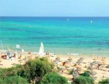
The quaint, rugged coast of Crimea is precisely this feature that attracts sailors and beachgoers. Numerous bays allow you to find both a convenient anchorage and a coastal edge that is not subject to the rage of waves. The Kalamitsky Bay of the Black Sea is not large in size, but its coasts are unique natural areas.
Where is Kalamitsky Bay located on the map?
It is located in Western Crimea. On its banks stand Zaozernoye, and Saki, Novofedorovka, Nikolaevka and Beregovoe, Peschanoye and.
Geographical details and features
This is where disagreements immediately begin. Classical - old - sources have always indicated that the bay is limited by Capes Evpatoriya and. Thus, it occupies a significant part of the western coast of the Crimean Peninsula. However, modern data “cut down” these indicators. In their opinion, the bay “does not reach Chersonesus”, and its border is.
It is not difficult to give a brief description of the bay. It protrudes into the land slightly less than , by 13 km, but has a wide entrance - according to modern data, 41 km. The depths vary, maximum 30 m, so even heavy vessels are not in danger of running aground. The height of the coast increases from north to south. In the area of Cape Evpatoria it is sloping, sandy, with extensive beaches. Towards the southern tip the coast rises, near the Lucullus ledge it is 15 m.
There are several salt lakes near the Kalamitsky Bay:
- Yaly-Moinak (Big and Small),
- Saki,
- Bagails.
A hydrographic study proves that they must once have formed part of the harbor, but were separated from it by embankments literally several meters wide. As a result, the properties of their filling and bottom silt changed. These are often called estuary.
Kalamitsky Bay in Crimea is considered a very clean water area of the Black Sea.  This is largely due to the fact that it is located far from the confluence. The rivers and Western Bulganak flow directly into it, within its modern borders, but they cannot create a strong suspension of brought soil in it. The purity of the water explains not only the tourist attractiveness of the region, but also its natural wealth.
Mutually exclusive translations
The Kalamita Bay region has long given philologists a lot of work to do. They cannot in any way establish the origin and meaning of its name. Yes, everyone knows about the existence of the medieval one, but for some reason fortification was also called that way! There are a lot of mutually exclusive versions, borrowed from different languages: “beautiful”, “good, comfortable cape” and even “misfortune, disaster”. The riddle, like so many different definitions, can be attributed to the same place.
The name “Lucullus” also raises questions. Many have heard about the existence of the Roman commander Lucullus, who loved to eat delicious food. He's probably been to these parts, but the outcropping of land still doesn't look like him. In fact, on the first known maps it was called in Tatar - Uluk-Kol. There really is a beam with that name (“long sleeve”) nearby. Probably, later the name, indigestible for the first Russian settlers, was changed into a more musical surname of a Roman military man.
Protection of life and health
Since the Kalamita Bay is famous for its cleanliness, holidays in this area are especially beneficial for health. Estuary lakes (the best known, but silt from others is used in a similar way) are a source of healing mud used in the treatment of many diseases of the nervous system, skin, musculoskeletal system, and respiratory organs.  Clean air and water complement the healing effect.
It warms up relatively quickly: the swimming season here lasts from May to September in favorable years. The beaches of Evpatoria enjoy a good reputation - sand is much more convenient for vacationers than pebbles. Many of them have a gentle entrance to the sea - this is one of the reasons that the city is especially recommended as a children's resort. The surrounding area is famous for its beautiful spacious beaches (the name speaks for itself). The small village is not as famous as Evpatoria, but it’s for the better - prices are lower and there is more space.
In addition to holidaymakers, marine life also liked the clean water. In order to protect the system in which the sea interacts with land, a reserve was created at Cape Lucullus. Its coastal complex is recognized as a natural monument. The flora and fauna here are very rich, including rare species. Adonis vernacular (Adonis) grows here, and the steppe rack, little bustard, steppe eagle, four-striped snake, and steppe viper are found.
Near Lucullus, archaeologists discovered the remains of a large settlement from Scythian times. Conventionally, it is called Ust-Alminsky. So far the archaeological site has not been identified based on written information, but it is clear that it was a fairly large policy. This object requires urgent research - a significant part of it has already been lost as a result of erosion by the sea.
How to get there (get there)?
You can get to Kalamitsky Bay from any corner of Crimea; buses in this direction are not uncommon from Simferopol, Yalta, Sevastopol, Feodosia and even Kerch.
We will show you on the map how to get there by car yourself, one of the very attractive ones here, from Simferopol:
Note to tourists
- Address: Western Crimea, Russian Federation.
- GPS coordinates: 45.002367, 33.566267.
Visitors should behave culturally so that the Kalamitsky Gulf of Crimea and its Black Sea environs can help improve the health of guests and preserve the biological diversity of the region for a long time to come.
Length of the Black Sea from west to east - 1167 km, from north to south - 624 km. The greatest depth is 2,212 m, and the average is 1,271 m. The length of the coast along the perimeter is 4,090 km, the length of the coastline reaches 4,340 km. The area of the Black Sea is 423,000 square meters. km.
Due to the excess inflow of fresh water from the rivers Danube, Dniester, Dnieper, Southern Bug, Mzymta, Bzybi, Kodor, Inguri and others. (more than 300 rivers) above evaporation it has less salinity than the Mediterranean Sea. Rivers contribute 346 cubic meters to the sea. km of fresh water and 340 cubic meters. km of salt water flows from the Black Sea through the Bosphorus.
Depth of the Black Sea
Black Sea is one of the deepest sedimentary basins in the world. The thickness of sedimentary deposits on the seabed is 14 km. The bottom relief is a deep basin with steep slopes, its maximum depth is up to 2211 m. The area of the Black Sea is 413,488 square meters. km. The maximum length is 1148 km, the maximum width is 615 km, the length of the Black Sea coastline is 4077 km.
The Black Sea washes the shores of Russia, Abkhazia, Georgia, Turkey, Bulgaria, and Ukraine.
There are few bays, bays and peninsulas in the Black Sea and almost no islands. This is due to the constant rise in sea level.
Composition of Black Sea water
Salty taste Sodium chloride gives sea water, and magnesium chloride and magnesium sulfate give it a bitter taste. Water contains 60 different elements. But it is assumed that it contains all the elements found on Earth. Sea water has a number of healing properties. Water salinity is about 18%.
About 87% of the Black Sea water volume is deprived of oxygen and is contaminated with hydrogen sulfide. At a depth of over 150 m, the water contains hydrogen sulfide, and therefore the sea is devoid of living organisms at great depths. The source of hydrogen sulfide is the decomposition of the remains of aquatic organisms; at a depth of 150-200 m, the hydrogen sulfide content reaches 7.5 cubic meters. cm per liter of water, and its total amount is a billion tons. The uniqueness of the Black Sea lies in the fact that in the deep layers of its water there are no algae, invertebrate animals and fish, there are no living creatures except sulfur bacteria.
Determined that age of the Black Sea about 8 thousand years.
Kalamitsky Bay is a part of the Black Sea, jutting into the western coast of the Crimean Peninsula between Capes Lucullus and Evpatoria. This bay is partially washed by the coast of Sevastopol in a small area from Cape Lukull to the administrative border with the Bakhchisarai region (only 1.5 km approximately). The entire area around Cape Lucullus is protected by the state as a nature reserve and is an object of a unique natural fund. The coastal aquatic complex occupies more than 125 hectares and is a hydrological natural monument.
Kalamita Bay. Geography
Kalamitsky Bay is a picturesque place. The width of the bay at the entrance is 41 km, 13 km from the entrance to the coast. The depth reaches 30 meters. The bay in the north ends at the city of Evpatoria. The shores in the south of the bay are clayey and high, while in the north they are low and sandy, with beaches in many places. Not far from the coast, behind sandy embankments there are salt lakes. The largest of them:
- Saki,
- Sasyk,
- Gull,
- as well as the healing lake Kyzyl-Yar.
Several rivers flow into the Kalamitsky Bay (Belbek, Alma, Bulganak and Kacha). Directly on the shore of the bay there are several settlements visited by tourists, including Beregovoye, Uglovoye, Novofedorovka, Andreevka, Nikolaevka, etc.
There are different versions regarding the name of the bay. The most common one associates the name with the city of Calamita, which was built by the Genoese. The city has not survived to this day. In Greek, Kalamita translates as “good cape.”
Sights and recreation areas
Not far from Cape Lucullus is the settlement of Ust-Alminskoye. This is a Scythian settlement that arose at the turn of the 2nd century BC. Its true name is not known. In fact, there were many ancient settlements in this part of Crimea, but not all of them have survived. For example, due to soil collapses into the sea, more than half of the Ust-Alminskoye settlement was irretrievably lost. 
There are many private hotels and boarding houses along the bay coast. Tourists who wish to come here will find a place to stop.
Some of them, for example, the Volna recreation center (information at) are located near the sea, but also not far from lakes or estuaries.
The city of Evpatoria is considered a children's health resort precisely because of the favorable climate and shallow water of the Kalamitsky Bay. The beaches are mostly sandy. Kalamita Bay warms up very quickly and often the swimming season begins in May and ends in September.