Eyyafjallajökull volcano eruption. Icelandic volcano Eyjafjallajökull eruption
Volcanoes are frightening and attract a person to them. For centuries they can sleep. An example is the recent history of the Eyjafjallajokull volcano. People cultivate fields on the slopes of fiery mountains, conquer their peaks, build houses. But sooner or later, the fire-breathing mountain will wake up, bringing destruction and misfortune.
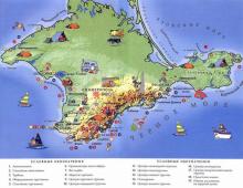
It is the sixth largest glacier in Iceland, located in the south, 125 km east of Reykjavik. Under it and partly under the neighboring Myrdalsjökull glacier, a conical volcano hides.
The height of the top of the glacier is 1666 meters, its area is about 100 km². The volcanic crater reaches a diameter of 4 km. Five years ago its slopes were covered with glaciers. The nearest settlement is the village of Skougar, located in the south of the glacier. From here the Skogau river starts, with the famous Skogafoss waterfall.
Eyyafyatlayokudl - the origin of the name
The name of the volcano comes from three Icelandic words that mean island, glacier and mountain. Perhaps that is why it is so difficult to pronounce and hard to remember. According to linguists, only a small part of the inhabitants of the Earth can pronounce this name correctly - Eyyafyatlayokudl volcano. Translation from Icelandic sounds literally like "island of mountain glaciers."

Volcano without a name
As such, the phrase "volcano Eyyafyatlayokudl" entered the world lexicon in 2010. This is funny, considering that in fact, a fire-breathing mountain with that name does not exist in nature. Iceland has many glaciers and volcanoes. There are about thirty of the latter on the island. At 125 kilometers from Reykjavik, in the south of Iceland, there is a fairly large glacier. It was he who shared his name with the volcano Eyyafyatlayokudl.

It is under it that there is a volcano, which for many centuries has not come up with a name. He is unnamed. In April 2010, he alarmed the whole of Europe, for some time becoming a world newsmaker. In order not to name it in the media, it was proposed to name it by the name of the glacier - Eyyafyatlayokudl. In order not to confuse our readers, we will call it the same.
Description
Eyjafjallajokull is a typical stratovolcano. In other words, its cone is formed by numerous layers of solidified mixture of lava, ash, stones, etc.
Iceland's Eyjafjallajökull volcano has been active for 700,000 years, but since 1823 it has been categorized as dormant. This suggests that no eruptions have been recorded since the beginning of the 19th century. The state of the Eyyafyatlayokudl volcano did not cause particular cause for concern for scientists. They found that it had erupted several times over the past millennium. True, these manifestations of activity could be classified as calm - they did not pose a danger to people. As evidenced by the documents, the latest eruptions were not distinguished by large emissions of volcanic ash, lava and hot gases.
Irish volcano Eyyafyatlayokudl - the story of one eruption
As already mentioned, after the eruption in 1823, the volcano was recognized as dormant. At the end of 2009, seismic activity intensified in it. Until March 2010, there were about a thousand tremors with a force of 1-2 points. This disturbance occurred at a depth of about 10 km.

In February 2010, employees of the Icelandic Meteorological Institute, using GPS measurements, recorded a displacement of the earth's crust by 3 cm to the southeast in the region of the glacier. Activity continued to grow and reached its maximum by March 3-5. At this time, up to three thousand shocks per day were recorded.
Waiting for the eruption
From the danger zone around the volcano, the authorities decided to evacuate 500 local residents, fearing flooding of the area, which could cause an intense covering of Iceland's Eyjafjallajökull volcano. Closed as a precaution international Airport Keflavik.
Since March 19, the tremors have moved to the east of the northern crater. They were tapped at a depth of 4 - 7 km. Gradually, the activity spread further to the east, and shaking began to occur closer to the surface.
At 23:00 on April 13, Icelandic scientists recorded seismic activity in the central part of the volcano, west of the two cracks that had formed. An hour later, a new eruption began in the south of the central caldera. A column of hot ash rose 8 km.

Another crack appeared, more than 2 kilometers long. The glacier began to melt actively, and its waters flowed both to the north and to the south, into populated areas. 700 people were urgently evacuated. During the day, meltwater flooded the highway, the first destruction occurred. Volcanic ash has been recorded in southern Iceland.
By April 16, the ash column had reached 13 kilometers. This caused alarm among scientists. When the ash rises above 11 kilometers above sea level, it enters the stratosphere and can be carried over long distances. The spread of ash in an easterly direction was facilitated by a powerful anticyclone over the North Atlantic.
Last eruption
This happened on March 20, 2010. On this day, the last volcanic eruption in Iceland began. Eyjafjallajokull finally woke up at 23:30 GMT. A fault formed in the east of the glacier, the length of which was about 500 meters.

At this time, no large ash emissions were recorded. On April 14, the eruption intensified. It was then that powerful emissions of gigantic volumes of volcanic ash appeared. As a result, it was closed air space over part of Europe until April 20, 2010. Occasionally, flights were limited in May 2010. Experts estimated the intensity of the eruption on the VEI scale at 4 points.
Dangerous Ash
It should be noted that there was nothing outstanding in the behavior of the Eyyafyatlayokudl volcano. After seismic activity that lasted several months, a rather calm volcanic eruption began in the region of the glacier on the night of March 20-21. It was not even mentioned in the press. Everything changed only on the night of April 13-14, when the eruption began to be accompanied by the release of a gigantic volume of volcanic ash, and its column reached a great height.
What caused the air transport collapse?
It is worth recalling that since March 20, 2010, an air transport collapse has loomed over the Old World. It was associated with a volcanic cloud, which was created by the suddenly awakened Eyyafyatlayokudl volcano. It is not known where this mountain, silent since the 19th century, gained strength, but gradually a huge cloud of ash, which began to form on April 14, covered Europe.

More than 300 airports across Europe have been paralyzed since airspace was closed. The volcanic ash also caused a lot of anxiety to Russian specialists. Hundreds of flights have been delayed or completely canceled in our country. Thousands of people, including Russians, were waiting for an improvement in the situation at airports around the world.
And the cloud of volcanic ash seemed to play with people, changing the direction of movement daily and completely “did not listen” to the opinions of experts who reassured desperate people that the eruption would not last long.
Geophysicists from the Icelandic weather service told RIA Novosti on April 18 that they were unable to predict the duration of the eruption. Mankind prepared for a protracted "battle" with the volcano and began to count considerable losses.
Oddly enough, but for Iceland itself, the awakening of the Eyjafjallajokull volcano did not have any serious consequences, except, perhaps, for the evacuation of the population and the temporary closure of one airport.
And for continental Europe, a huge column of volcanic ash has become a real disaster, of course, in the transport aspect. This was due to the fact that volcanic ash has such physical properties that are extremely dangerous for aviation. When it enters the aircraft turbine, it is able to stop the engine, which will undoubtedly lead to a terrible disaster.
The risk to aviation is greatly increased due to the large accumulation of volcanic ash in the air, which significantly reduces visibility. This is especially dangerous when landing. Volcanic ash can cause malfunctions in the operation of on-board electronics and radio equipment, on which flight safety largely depends.
Losses
The Eyjafjallajokull volcano eruption caused damage to Europe travel companies. They claim that their losses exceeded $ 2.3 billion, and the damage that hit the pocket every day was approximately $ 400 million.
Airlines' losses were officially estimated at $1.7 billion. Awakening fiery mountain affected 29% of world aviation. Every day more than a million passengers became hostages of the eruption.
The Russian Aeroflot also suffered. During the closing period overhead lines over Europe, the company did not complete 362 flights on time. Her losses were in the millions of dollars.
Expert opinions
Experts say that the volcanic cloud really poses a serious danger to aircraft. When an aircraft hits it, the crew notes very poor visibility. On-board electronics work with big interruptions.
The resulting glassy “shirts” on the engine rotor blades, clogging of the holes that are used to supply air to the engine and other parts of the aircraft, can cause their failure. The captains of the airships agree with this.
Volcano Katla
After the activity of the Eyjafjallajokull volcano faded, many scientists predicted an even more powerful eruption of another Icelandic fiery mountain - Katla. It is much larger and more powerful than Eyyafyatlayokudl.
For the last two millennia, when man watched the eruptions of Eyyafyatlayokudl, Katla also exploded after them at intervals of six months.
These volcanoes are located in the south of Iceland, at a distance of eighteen kilometers from each other. They are connected by a common underground system of magma channels. The Katla crater is located under the Myrdalsjokull glacier. Its area is 700 sq. km, thickness - 500 meters. Scientists are sure that during its eruption, ash will fall into the atmosphere ten times more than in 2010. But fortunately, despite the menacing forecasts of scientists, Katla has not yet shown signs of life.
.
Eyjafjallajökull volcano eruption(also "Eyyafjadlayok at dl"; isl. Eyjafjallajokull) in Iceland began on the night of March 20-21, 2010 and took place in several stages. The main consequence of the eruption was the release of a cloud of volcanic ash, which disrupted air traffic in Northern Europe.
First eruption.
Since the end of 2009, seismic activity has increased in Eyjafjallajökull. Until March 2010, there were about a thousand tremors with a force of 1-2 points at a depth of 7-10 km under the volcano.
At the end of February 2010, GPS measurements conducted by the Icelandic Meteorological Institute in the region of the glacier recorded a movement of the earth's crust by 3 cm in a southeasterly direction. Seismic activity continued to increase and reached a maximum on March 3-5 (three thousand tremors per day).

Temperature map
About 500 local residents were resettled from the area around the volcano (since the intense melting of the glacier under which the volcano was located could cause flooding of the area). Keflavik International Airport (city of Keflavik) was closed.
On March 19, shaking began east of the northern crater at a depth of 4-7 km. Then the activity began to spread to the east and rise to the surface.
The volcanic eruption began on March 20, 2010 between 22:30 and 23:30 GMT. At that time, a 0.5 km long fault formed in the eastern part of the glacier (at an altitude of about 1000 m above sea level, in the direction from northeast to southwest). During the eruption, large ash emissions were not recorded, the cloud rose to a height of about 1 km.
On March 25, due to the water of the melted glacier that got into the crater, a steam explosion occurred in the crater, after which the eruption moved into a more stable phase.
On March 31, at about 19:00 (Icelandic time), a new fissure (0.3 km long) opened, which is located about 200 m northeast of the first one.
Second eruption.

Second eruption, view from the north, April 2, 2010
On April 13, around 23:00, seismic activity was recorded under the central part of the volcano, to the west of the two erupting fissures. About an hour later, a new eruption began on the southern edge of the central caldera. The ash column rose 8 km. A new fissure was formed about 2 km long (in the direction from north to south). Water from the active melting of the glacier flowed both north and south into inhabited areas. About 700 people were evacuated. During the day, melt waters flooded the highway, causing damage. Volcanic ash has been recorded in southern Iceland.

Trail of the volcanic eruption on April 15 in the area of high pressure over the Norwegian Sea. Aqua satellite image.
On April 15-16, the height of the ash column reached 13 km. When ash hits a height above 11 km above sea level, it enters the stratosphere with a possible transfer to considerable distances. The anticyclone over the North Atlantic contributed to a significant spread of the ash cloud in an easterly direction.

Trail of the volcanic eruption on April 15. Aqua satellite image.
On April 17-18, the eruption continued. The height of the ash column was estimated at 8-8.5 km, which means the cessation of the ingress of igneous material into the stratosphere.
Impact on air traffic in Europe.
On April 15, 2010, due to the high intensity of the eruption and ash emission, air traffic was suspended in northern Sweden, Denmark, Norway and northern regions Great Britain.
Due to the high concentration of volcanic ash in the air on April 15, 2010 (the ash cloud rose to a height of 6 km), all UK airports stopped their work from noon, and Danish airports were closed from 21:00 Moscow time. On April 15, 2010, between 5,000 and 6,000 flights were canceled across Europe.
At the same time, the airspace of Iceland itself and its airports remained open.
Flights to Europe from America and Asia (USA, China, Japan) were postponed indefinitely.
According to the calculations of the International Air Transport Association, the daily losses of airlines from flight cancellations amounted to at least 200 million USD.
The Association of European Airlines on April 19 called for an "immediate review of restrictions and bans" on flights in the airspace of the European Union. According to the results of test flights conducted by some European airlines, the ash does not pose a danger to air traffic. The International Air Transport Association has criticized European governments for their lack of thoughtfulness in imposing flight bans. " The European governments decided without consulting anyone and without adequately assessing the degree of risk,- said the head of ICAO Giovanni Bisignani. - It is based on theory, not facts.».
According to CEO EU transport organization Matthias Root's flight ban was prompted by a computer program of dubious scientific value that simulates the spread of volcanic ash. He urged EU leaders to consider adopting US-style safety rules. " On the other side of the Atlantic, airlines would be given one piece of advice: don't fly over a volcano. Everything else necessary measures precautions would be left to the carriers themselves to determine”, said Matthias Ruth.
The volcanic eruption prevented the leaders of many heads of state from flying to the funeral of Polish President Lech Kaczynski and those killed in a plane crash near Smolensk on April 10, 2010.
Distribution of volcanic ash in Russia.
According to the Met Office, UK, as of 18:36 April 18, 2010, volcanic ash in Russia was recorded in the area Kola Peninsula, south of Central federal district, parts of the Volga, Southern and North Caucasian federal districts, as well as in the northeast of the Northwestern Federal District. St. Petersburg was on the border of the expected spread of ash, according to forecasts, the ash was supposed to reach the city on the night of April 18-19. Volcanic ash was not registered on the territory of Moscow, and its distribution was not expected in the next day (April 19).
According to other information, the first particles of volcanic ash reached Moscow on April 16, 2010. On the night of April 16-17, small particles of ash could be collected on a sheet of paper placed on the windowsill. The study of particles under a microscope showed the presence of fragments of plagioclase crystals and foamed volcanic glass.
Marina Petrova, director general of the meteorological agency Roshydromet, said on April 19 that Russian experts do not observe volcanic ash over the territory of Russia. Director of the Federal Information and Analytical Center of Roshydromet Valery Kosykh said that the data on ash over Russia is based on information from the London Volcanic Ash Tracking Center. “The main problem is that no one in Russia can measure the concentration of this ash,” he said.
Volcanic ash distribution patterns.

Ash cloud spread by April 17, 2010 18:00 UTC.

Ash cloud spread by April 19, 2010 18:00 UTC.

Ash cloud spread by April 21, 2010 18:00 UTC.

Ash cloud spread by April 22, 2010 18:00 UTC.
Impact on the environment.
Volcanic eruptions emit huge volumes of aerosols, suspended particles, which are carried by tropospheric and stratospheric winds and absorb part of the solar radiation. The 1991 eruption of Mount Pinatubo in the Philippines sent so much ash to a height of 35 km that the average level of solar radiation decreased by 2.5 W / m 2, which corresponds to a global cooling of at least 0.5-0.7 ° C, but, according to IGRAN Deputy Director for Science Arkady Tishkov, “ something that went up in the air in Iceland until it even reached a volume of one cubic kilometer. These emissions are not as large as, for example, those that were noted as a result of recent eruptions in Kamchatka or Mexico.". He believes that the " this is a completely normal event.”, which may affect the weather, but will not cause climate change.
Scientists record outbreaks of giant and the most dangerous volcano Katla in Iceland, who was silent for almost a hundred years. A volcanic explosion can be so massive that the volcano releases toxic ash into the atmosphere that can instantly kill more than 200,000 people. Katla is a close neighbor of the Eyjafjallajökull volcano, whose eruption in April 2010 caused the worst aviation collapse since World War II.
Deep under a glacier in Iceland, a massive catastrophe is brewing. According to experts, the Katla volcano, popularly known as the "evil sorceress", is preparing to unleash its deadly wrath on the whole of Northern Europe.
Katla is a volcano south coast Iceland, one of the largest in the country.

AT this moment Katla shows all the clear signs of an imminent explosion. It can be so colossal that the volcano will release toxic ash emissions into the atmosphere that can instantly kill more than 200,000 people. Scientists fear that Katla will again plunge Europe into chaos, as in 2010, when the eruption of its neighbor, the Eyjafjallajökull volcano, led to the largest air collapse since the Second World War. A powerful ash column practically paralyzed air traffic - millions of people were stuck in Northern Europe from mid-April to mid-May.

In total, 14 Katla eruptions are known. Previously, the volcano erupted every 50-80 years, but since 1918 it has been silent - during the last eruption, it threw five times more ash into the sky than its neighbor Eyjafjallajökull in 2010. Katla's eruption predicted today will be the first in nearly 100 years. Currently, Katla emits 12 to 24 kilotons of carbon dioxide daily, the volcano's magma chambers are filling up, which indicates an impending disaster and makes experts sound the alarm.

The peak of seismic activity in Iceland occurs in autumn, which carries the highest risk of eruptions. The accumulation of magma inside Katla is greatly enhanced by the presence of a glacier on its crater - this acts in the same way as the lid on a giant pressure cooker. The fact that the volcano is hidden under glaciers also makes it much more difficult to monitor its activity.
Katla is far from the major settlements of Iceland, and the eruption does not threaten the locals. One of the main dangers is that volcanic activity Katly is capable of causing powerful melting of nearby glaciers and flooding of neighboring areas with melt water.

The Icelanders have a legend about Katla that goes back over eight centuries. According to legend, Katla is the name of a hot-tempered and cruel housekeeper at a local monastery who possessed supernatural powers. Once, when she was accused of witchcraft, the "evil witch" escaped and jumped into the Mýrdalsjökull glacier (which is located above the volcano). An eruption began, destroying the monastery and killing all its inhabitants. Legend warns that one day Katla will return for revenge.
Eyjafjallajökull volcano has woken up in Iceland after a 200-year "hibernation". The eruption began on March 21, 2010 and was so powerful that a state of emergency was declared in the country and hundreds of residents were evacuated from nearby settlements
Russia 1
Eyjafjallajökull volcano has woken up in Iceland after a 200-year "hibernation". The eruption began on March 21, 2010 and was so powerful that a state of emergency was declared in the country and hundreds of residents of nearby settlements were evacuated.
On April 14, a new eruption began, accompanied by the release of a huge amount of ash into the atmosphere. The next day, a dozen European countries were forced to completely or partially close their airspace - in particular, flights were canceled at the airports of London, Copenhagen and Oslo.
Eyyafjallajokull(Eyjafjallajokull) means "Island of mountain glaciers". The volcano is located 200 kilometers east of Reykjavik between the Eyjafjallajokull and Mirdalsjokull glaciers. These are the largest ice caps in the south of the northern island country, covering active volcanoes.
The Eyjafjallajökull volcano is a conical glacier, the sixth largest in Iceland. The height of the volcano is 1666 meters. The diameter of the crater is 3-4 kilometers, the glacial cover is about 100 square kilometers.
Iceland lies on the Mid-Atlantic Ridge, where volcanic eruptions occur quite frequently. Almost all types of volcanoes found on Earth are represented in this country. Ice caps and other glaciers cover an area of 11,900 square kilometers.
Since many volcanoes in Iceland are covered with glaciers, they often melt them from below. The tongues of the glaciers break away from their places, releasing millions of tons of water and ice, which demolish everything in its path.
It is from these fears that such serious security measures were taken in Iceland after the awakening of Eyjafjallajökull in 2010. In particular, after its March eruption, traffic on nearby roads was stopped and residents were evacuated. Local authorities feared that the volcanic lava would melt the glacier and cause severe flooding.
However, after the research, experts came to the conclusion that the eruption does not pose a threat to local residents. A few days later, the authorities allowed people to return to their homes.
Volcanologists were able to approach the crater at a distance of several meters and film the eruption on camera, they saw that the crack from which the lava comes out has a length of about 500 meters. In addition, the shooting was carried out from the air. The set was published on the popular YouTube video portal.
Here is one of these shootings - a spectacle that is bewitchingly beautiful and frightening at the same time.
Icelandic scientists have been watching the volcano for a long time, looking for signs of seismic activity. In their opinion, the eruption may last another year or even two. The last eruption of Eyjafjallajökull was recorded in 1821. Then it lasted until 1823 and caused a threatening melting of the glacier. In addition, due to the high content of fluorine compounds (fluorides) in its emissions, a threat to health, namely the bone structure of people and livestock, has been created.
In the spring of 2010, a volcano erupted in Iceland. A huge cloud of ash was thrown into the atmosphere, as a result of which the airspace of most of the continent was closed, and many flights were canceled. Photos of the grand spectacle in huge number went on the Internet, and the name of the volcano - Eyjafjallajokull (Eyjafjallajokull, in translation - "Island of mountain glaciers") gave rise to many anecdotes (though, mostly in printed form, it's not so easy to pronounce this word).
(Log in to clean up the page.)
Photo spectacle
People all over the world admire the extraordinary spectacle - some live, some in the photo.
1. Lava erupts from the Eyjafjallajokull volcano against the backdrop of lightning on April 17th. (REUTERS/Lucas Jackson)

2. A volcano near the southern Eyjafjallajokull glacier sends ash into the air at sunset on April 16. Thick puffs of volcanic ash enveloped parts of the Icelandic countryside, and an invisible plume of sand and dust swept over Europe, clearing the skies of planes and forcing hundreds of thousands of people to rush to search for hotel rooms, train tickets and hire a taxi. (AP Photo/Brynjar Gauti)

3. A car drives along a volcanic ash-strewn road near Kirkjubaeyarklaustur. (AP Photo/Omar Oskarsson)

4. Chunks of ice from a glacier lie against the backdrop of an erupting volcano near Eyjafjallajoku on April 17. (REUTERS/Lucas Jackson)

5. An airplane flies past a pillar of smoke and ash from the Eyyafyatlayokudl volcano on April 17. (REUTERS/Lucas Jackson)

6. Eyyafyatlayokudl volcano in all its splendor. (AP Photo/Brynjar Gauti)


8. Ashes and a column of dust and dirt erupt from the crater of the Eyyafyatlayokudl volcano. (AP Photo/Arnar Thorisson/Helicopter.is)

9. An ash plume stretches south from the Eyjafjallajokull volcano over the northern part Atlantic Ocean. The picture was taken from a satellite on April 17. A volcano in Iceland erupted another portion of ash and smoke on April 19, but the ash cloud that plunged airlines and tour operators across Europe into chaos fell to a height of 2 km. (REUTERS/NERC Satellite Receiving Station, Dundee University, Scotland)

10. Lava and lightning illuminate the crater of the Eyyafyatlayokudl volcano. (REUTERS/Lucas Jackson)

11. The first of three photographs taken by Olivier Vandeginste 25 km from the crater of the Eyjafjallajokull volcano on April 18. The picture was taken with a 15 second exposure. (Olivier Vandeginste)

12. The second photo of Olivier Vandeginste, taken 25 km from the Eyjafjallajokull volcano. In this 168-second exposure, the pillars of ash are illuminated from within by numerous lightning bolts. (Olivier Vandeginste)

13. Third photograph by Olivier Vandeguinste. Lightning and hot lava illuminate parts of the Eyjafjallajokull volcano. The picture was taken with a 30 second exposure. (Olivier Vandeginste)

14. Lava fountains and flows, a volcanic plume and steam from evaporating snow are visible in this natural-color satellite image. The picture was taken on March 24 by the ALI instrument aboard the Earth Observing-1 satellite. Lava fountains (orange-red) are practically invisible through the lens of the device with a resolution of 10 meters. The cinder cone surrounding the fissure is black, as is the lava flow flowing to the northeast. White volcanic gases and lava rise from the fissure, and where lava meets snow, steam rises into the air. (The bright green stripe along the edge of the lava flow is sensor distortion.) (NASA's Earth Observatory/Robert Simmon)

15. Tourists gathered to watch the Eyyafyatlayokudl volcano spewing lava on March 27. On the morning of April 14, more than 800 people were evacuated in the area of the awakened volcano. (HALLDOR KOLBEINS/AFP/Getty Images)

16. People gathered to look at the lava flow of the Eyjafyatlayokudl volcano on March 27. (HALLDOR KOLBEINS/AFP/Getty Images)


18. Steam and hot gases rise above the lava from the Eyjafjallajokull volcano on April 3. (Ulrich Latzenhofer / CC BY-SA)

19. A farmer photographed the volcano shortly after it erupted. (Zuma Press).

20. Since many volcanoes in Iceland are covered with glaciers, they often flood them from below. The tongues of the glaciers break away from their places, releasing millions of tons of water and ice, which demolish everything in its path.

21. A picture of the volcano Eyyafyatlayokudl from space. It has three craters, ranging in size from 200 to 500 meters in diameter.

A few more photos.


Jokes and anecdotes
Written in a mixture of Icelandic and Norwegian. “Put 30 billion Euros in a dumpster outside the Icelandic embassy tonight, then we will turn off the volcano! Don't call the police."

Mystery of the name

In response to the actions of Iceland, Greenland begins to push into the ocean
icebergs.
New expletive: "Eyafjallajokull to you all over Europe!"
“Did you hear that Eyjafjallajokull came to life?
“Are you sure it’s not Hvannadalsnukur?”
- Of course, Hvannadalsnukur is near Kaulvafellsstadur itself, and Eyjafjallajokull is closer to Vestmannaeyjar if you go towards Snaefellsjokull.
- Thank God, otherwise I have relatives in Brunholskirkja!
If you read this dialogue aloud without hesitation, then you are an Icelander.
Patter: "Eyafyadlaekudl ejaculated, ejaculated, but did not ejaculate."
According to Mayan predictions, until all Europeans learn the word "Eyyafyaldaeküll", the volcano will not stop erupting. If it's hard for you to pronounce it, I suggest remembering the phrase: "Hey, I'm drunk, and forge with him."
We sat with you by the window, eating apple strudel. Both of us can't sleep anymore because Eyafjadlajokull.
"Eyyafyatlayokudl" - whatever you call a boat, that's how it will float.
News anchors are in quiet horror: according to rumors,
the eruption of the Eyjafjallajokull volcano in the near future may be added and
pyroclastic flows from the Mexican mountain Popocatepetl.