Map of Cyprus with resorts in Russian. New map
Cyprus is an independent state on an island located in the Mediterranean Sea, east of Greece, west of Lebanon, Syria and Israel, south of Turkey and north of Egypt.
Paper maps of Cyprus are available free of charge in almost all hotels and tourist areas, travel agencies and at airports thanks to the Cyprus Tourism Organization (CTO).
Here you can view and download maps of Cyprus in Russian:
General map of Cyprus in Russian
(click on the picture to download the full version, 1.3Mb)

Map of Cyprus with attractions
(click on the picture to download the full version, 1.5MB)

Administrative map of Cyprus
(click on the picture to download the full version, 1.1Mb)

Map of Cyprus with picnic areas
(click on the picture to enlarge)

Map of Cyprus for hunters
(click on the picture to download the full version, 2.4Mb)

(click on the picture to download the full version)

Geography
The island's landscape is one of the most interesting on Earth, and tourists come all year round to experience this diversity. Picturesque coastline, steep mountains, fertile hills and endless sandy beaches!
Climate
The island's climate is excellent. Cyprus has long, dry summers starting in May and ending in October, with maximum temperatures in July and August. The rains begin at the end of October and continue until April. Peak rainfall occurs between December and February.
It has a unique weather dynamic where it snows in the Troodos Mountains in winter, and at the same time you can enjoy comfortable sea level temperatures and sunshine - you can even go swimming in winter!
Average temperatures at sea level:
- in winter 12-15°C
- in summer 34-37°C
Facts about Cyprus
The island is known for its vineyards, citrus and olive orchards, and mountains with pine forests.
More than 17% of the territory is forest.
Here are some of the most beautiful and clean beaches in Europe.
The island has two mountain ranges, Troodos in the south and Pentadaktylos in the north. Troodos, just an hour's drive from the coast, offers superb, soothing silence.
Two international airports provide easy access to anywhere in the world.
The island has one of the lowest crime rates in the world.
The swimming season begins in April and lasts until November.
Everywhere on the island you can find ancient villages that have changed little over the centuries.
The country produces the largest amount of grapes in the world, relative to its size and population. Most vineyards are small and grow local varieties primarily for wine. Some of them are still processed with the help of donkeys.
Many people fall in love with the island from day one, and decide to stay here because the quality of life here is much higher due to the idyllic climate, relaxed pace of life, and the special warmth and hospitality of the Cypriots.
But they find it difficult to answer simple questions: what continent does Cyprus belong to, what seas is it washed by, what kind of country is it? Meanwhile, for an attentive tourist, the location of Cyprus on the world map will serve as the key to the mystery and will clarify a lot.
Some numbers and facts
- The dimensions of the island are 230 km by 100 km at the widest point, which is smaller than the average region of the Central Federal District of the Russian Federation.
- subtropical in latitude, but not humid, without sudden changes in temperature and frosts, soft, favorable - the sun shines 300 days a year.
- just under a million, of which 50 thousand are Russian speakers.
- Turkey is 70 km from the mainland, Syria is 105 km and Egypt is 350 km.
- Cyprus does not occupy the entire island, part belongs to the Turks, the British and the UN.
Interestingly, centuries-old strife has divided the island into 2 main camps. The left side and the bottom, if you draw a diagonal, is the southern, so-called Greek, the same Republic of Cyprus. The upper right part is , which is recognized only by Türkiye, Abkhazia and Azerbaijan.
Europe or Asia
Geographically, the island of Cyprus on the world map gravitates toward Asia; its closest neighbors are Egypt, Turkey, Greece, and Syria. Despite the fact that it is now part of the EU and the group of Schengen countries, it has not yet become a full-fledged European country. There are too many disagreements that cannot currently be resolved peacefully.
It is obvious that the location of Cyprus on the map, separating many states from the Mediterranean Sea, did not give rest to the great empires. Before the republic became independent in 1960, it experienced endless influences and trends, some of which persist to this day.
From the ancient Greeks - cultural image and religion, from the Roman Empire and then Byzantium - the flourishing of art and architecture, from four centuries under the Ottoman Empire - enmity with the Turks at the genetic level, from Great Britain - driving on the left and, from Europe - the euro, a pragmatic way of life and plans for the future.
While the republic is at a crossroads, unresolved territorial issues with the East are preventing it from becoming Europe, so for many the island of Cyprus on the world map resembles a pinned helpless lizard or a fallen leaf that drifts in a stormy stream and does not know where it will end up.
How a tourist can understand Cyprus
Deciphering the physical map of the world tells us that although the island is located in the Mediterranean Sea, it is nevertheless washed by three calm and warm seas: the Levantine, Cyprus and Cilician. This means that the water warms up quickly, and there are practically no storms or hurricanes.
There are two mountain ranges along the island, they dominate the plain and insist on the volcanic theory of the origin of the island - which means it is predominantly black and gray, large, and the coastline is uneven, indented by bays and rocks. Surprisingly, the Cypriots were able to organize a ski resort on the top of the ridge, which is rare for such small islands.
Looking at Cyprus on the map, you can immediately identify tourist areas, they are located near large cities by Cypriot standards by the sea, notice the scarcity of vegetation, which also affects the animal world, and pay attention to the extensive network of roads. For many tourists, such information will help them better plan their vacation and roughly understand what to expect from visiting the country.
The island of Cyprus on the world map is tiny, almost unnoticeable, nestled in the fertile north-eastern part of the Mediterranean Sea under the Turkish resorts, but worthy of visiting by tourists and has a rich history, full of attractions.
Tourist map of Cyprus: settlements, highways, attractions, beaches.
Map of Cyprus for tourists
Tourist map of the island of Cyprus
Here is the detailed Cyprus tourist map- download
Which was published by the Cyprus Tourism Organization (COT).
It will not be difficult to navigate it, although it is in English. Symbols have been translated into Russian for ease of reference.
For autotourists, the Cyprus tourist map is very useful because it is an indispensable assistant on the road. Major and minor highways between small and large settlements are all before your eyes.
It shows motorways between the major cities of Cyprus. For example, we can see that you can get from the resort town of Paphos to another, no less resort town of Limassol, along the A6 highway.
Lovers of antiquity will find here the location of ancient monuments and antiquities of world cultural heritage protected by UNESCO. Castles and fortresses, museums and other attractions are also available.
You can easily find churches, temples, monasteries by the characteristic icon with a “cross” and the name, which is highlighted in red.
On the Cyprus tourist map you will find the location of municipal beaches and popular recreation areas - campsites and picnic areas.
English language.
Image resolution - 5144x3348 pixels.
File size - 4 MB.
Tourist map of Cyprus in RAR archive - download
What do you need to come to Cyprus?
- Visa you need to get a preliminary one. It's free. See how to do this -
- Insurance for those traveling abroad you can calculate -
- Flights look to Larnaca airport (more flights there) or Paphos (not so popular) -
- Hotels in the resorts of Cyprus, as well as all the information on them (available rooms, prices, reviews), tourists usually look at -
- Apartments with a discount I usually look for -
- Tours to Cyprus. Buy a tour from 60,000 rubles until 30.06 with a promo code AF1000kipros and get a RUB 1,000 discount -
- Transfer You don’t need to go to the hotel if you are flying on a tour. As a rule, this service is included in the tour price. If this is not the case, then order a transfer in advance via the Internet. It is very convenient and cheaper than taking a taxi from the airport. You will be met at the airport and taken straight to your hotel doorstep -
- Rent a Car- a very popular way to get around the island, so if you have a license, you can look at car rental prices -
- Excursions from local residents with unusual routes, see -
- Adapter for Cypriot sockets, which tourists use, can be bought in any store, but see what it looks like -
0
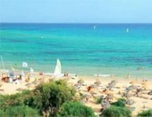
The island of Cyprus is a place where every place is suitable for relaxation. After all, there are so many cities and famous resorts on the island. For example, Larnaca, Protaras, Ayia Napa, Limasson and, of course, Paphos. Which one should you choose for your holiday? A new map of Cyprus with resorts in Russian will help you with this, which identifies all the best resorts in Cyprus. You will see where they are and how close they are to the sea. Thanks to the map, you can easily determine the place where you will feel comfortable and happy.
How to choose the right resort in Cyprus?
There is no exact algorithm for this. Therefore, here you have to rely on tourist reviews or your instincts. After all, each resort is beautiful and unique in its own way. For example, somewhere there is no wind, since the resort’s beaches are located in a bay that hides the coast from the winds. And which resorts can boast of sunny days all summer long? It doesn't rain on them.

Also, do not forget about the infrastructure, especially hotels. Since the weather in Cyprus is hot and dry almost all summer, it is important to choose the right hotel. The room, even the cheapest room, should have air conditioning and a shower with a bath. If there is no air conditioning, it is simply unrealistic to sleep at night when the air temperature is below +25. And if the room does not have a shower, how will you wash and take a bath? Therefore, when choosing a resort, choose a hotel so that it has everything.
When choosing a resort, also pay attention to its location. Naturally, resorts located in the south are the hottest. And the northern resorts are a little cooler. Although this is not so noticeable in summer, but in spring and autumn the difference is colossal. In southern resorts, the water warms up faster and cools down more slowly. While on the northern part of the island the sea water becomes optimal at the beginning of summer, and is already quite cool at the beginning of autumn.

In Cyprus, almost all beaches are sandy. Therefore, the choice here is not so critical. But what is important is that the beaches belong to the municipality, so entry to them is free! There are also exceptions when the beach belongs to the hotel. Then only hotel guests can enter it. But this is even better, since there are no strangers on the beach, it is always clean and completely at your disposal.
Well, next we will show you a map of the island's resorts. See and choose your resort and enjoy your vacation!
By the way!
The map is interactive and you can zoom in and out to get a better look at each resort.
The state of Cyprus is located on an island of the same name in the northeast of the Mediterranean Sea.
The shape of the island on a detailed map of Cyprus resembles a quadrangle, in the upper right corner of which the tip of the Karpas Peninsula is elongated. It ranks third among the largest in the Mediterranean.
Cyprus is favorably located from a strategic point of view, located at the crossroads of Asia, Europe and Africa, although geographically it belongs to Western Asia - a region covering the Arabian and Asia Minor peninsulas, the eastern parts of the Mediterranean Sea, the Caucasus, the Armenian and Iranian plateaus, and the Mesopotamian lowlands. The main trade routes historically passed through it, which determined the rich historical past of the state.
Today, the island is divided between the Greek Republic of Cyprus (57.6% of the territory) and the Turkish Republic of Northern Cyprus (36% of the territory), not recognized by the world community, the rest of the territory is occupied by a UN buffer zone and British military bases.
Cyprus on the world map: geography, nature and climate

Cyprus on the world map is surrounded on four sides by its neighbors, the distance to which is - from the east 105 km to Syria, in the north 75 km to Turkey, in the west 390 km to Rhodes, and in the south 370 km to Egypt.
Relief
The area of the island occupies 9251 sq. km. In order to cross it, you need to drive only 96 km; it stretches 241 km in length. The island is of volcanic origin. Its geography is determined by two mountain ranges - Kyrenia in the northeast and Troodos in the South-West. The mountains are different from each other - the Kyrenia chain consists of sheer steep cliffs, its highest point is Mount Akromanda, 1023 meters high. The Troodos massif is characterized by high altitudes, with seemingly flat hills. The highest point of the island is located here - Mount Olympus(1951 m).
Between the mountains that occupy most of the island are the fertile plains of Mesaoria and Morphou. In the autumn-winter period, their lands are irrigated by the waters of the Pedieos and Akaki rivers, thanks to which grains and citrus fruits are grown here, olive groves are adjacent to vineyards.
The relief of the plain is gently rolling, decreases to the east and passes into the low-lying coastal bays of Famagusta and Larnaca. It is the plains that determine the presence of wide coastal zones in the south and southeast of Cyprus. If you look at a map of Cyprus in Russian, you can easily find all six bays of the island: in the south there are Akrotiri and Episkopi, in the north-west - Chrysochou and Morphou, in the south-east Larnaca and Famagusta in the south.
Water resources
There are no permanent sources of fresh water in Cyprus. The rivers fill with water only during the rainy season, but in the summer they practically dry up. The longest river on the island is Pedieos (100 km), which originates in the Troodo Mountains, flows through the capital of Cyprus and flows into the sea in the south, in the Gulf of Famagusta. There are two lakes in Cyprus, they are located in Larnaca and Limassol, and they also dry up during the hot season. Previously, they were lagoons, but over time and changes in the coastline, they became cut off from the sea and formed salt lakes.
Climate
The climate of the island is subtropical, Mediterranean. The summer season is characterized by hot, dry weather, the autumn-winter season brings rain, and snow falls only in the mountains. The average temperature of the hottest month of the year - August - is 30 degrees, in mid-January - 12. The maximum temperatures of the corresponding months are over 40 and 19 degrees, respectively. The number of sunny days per year exceeds 320. The tourist season opens in May and lasts until the end of October, although many tourists also spend the winter here.
Flora and fauna
The nature of the island is diverse, due to the presence of different climatic zones and reliefs - mountains, plains, sea. 140 species of trees, shrubs, and flowers growing here are endemic, that is, they are not found anywhere else. The bulk of them are in the mountainous regions - Troodos and Kyrenia. In Cyprus you can find various types of coniferous trees - pines, cedars, junipers. Oaks and cypresses are common. There are many flowering shrubs - oleander, hibiscus, jasmine. The Cypriot cyclamen is considered the symbol of Cyprus; orchids and lavender also grow.
The fauna, unlike the rich flora of Cyprus, is not diverse, and is mainly represented by amphibians - frogs, lizards, turtles. The forests are inhabited by foxes, hedgehogs and hares. Mouflon, listed in the Red Book, can be found in the mountains. The island is crossed by the migration routes of migratory birds - partridges, quails; pink flamingos fly to the Salt Lake of Larnaca for the winter.
Map of Cyprus with cities. Administrative division of the country

Presented in two levels. At the first, enlarged level, the republic is represented by 6 dioceses, uniting the city of the same name, its suburbs and rural settlements. They can be easily found on a map of Cyprus with cities in Russian. Two dioceses - Famagusta and Kyrenia - are located on the territory of Northern Cyprus, three - Larnaca, Limassol and Paphos - on the territory of Greek Cyprus, and the capital Nicosia is divided between the two states.
At the second level, the Greek part of the republic is divided into 33 communities or municipalities that deal with the pressing problems of the population.
Nicosia is the only divided capital in the world, and is the same for both the Greek Republic of Cyprus and the Turkish Republic of Northern Cyprus. The city is located on the Mesaoria plain, on the banks of the Pedieos River, and has no access to the sea.
Limassol- the largest city in Cyprus, located on the southern coast of the island, in the Gulf of Akrotiri. It has a seaport, due to which it is a developed economic center, as well as a winemaking center. There are gently sloping sandy beaches along the coastline, so the city attracts many tourists.
Municipality of Strovolos formally considered a suburb of Nicosia, but its size allows it to be considered more of a city, and the second largest in Cyprus after Limassol. 70,000 people live here. Local authorities have created 65 parks in the municipality, covering a total of 340,000 sq.m. of greenery.