Star Fortress is the key. Star fortresses in Russia and in the world
Today I just want to admire the beauty of these fantastic structures!!
Italy
Across the planet, many fortress cities of the so-called stellar configuration have been preserved. There are hundreds of them. They are found in abundance in Europe, Asia, Africa, North and South America. All of them were built at different times, but most of them in the Middle Ages. All the beauty of these unusual structures can only be truly appreciated from a bird's eye view. And although many of them are empty or have long turned into ruins, you just need to rise above the ground a little, and you will see something incredible ... Everyone is surprised by the lines of Nazca, but these fortress cities of absolutely correct form are no less amazing. How was it planned and built? You are only amazed when looking at their pictures, how symmetrically everything is done! But the result can only be assessed from a great height.

One of the most famous star fortresses is fortress city of Palmanova- one of the outposts of the Venetian Republic. The city was founded in 1593, its construction was organized by the government of Venice.
As you can see, the outlines of the city from the old image completely coincide with the modern one, made with the help of aerial photography.
One of the interesting places in the Netherlands, which stands out clearly on Google satellite images - fortress Naarden. The fortified city of Naarden is interesting and notable for two things - firstly, its amazingly beautiful symmetrical shape, and secondly, the excellent condition of the fortifications. In plan, the fortress is an intricate figure resembling a six-pointed star with arrow-shaped shapes along the edges.
The fortress is located on a man-made island and has 6 symmetrical bastions.
Bourtange. Another 16th century star fortress in the Netherlands.
It was built in 1593 by order of William I of Orange to control the only road between Germany and Groningham during the Eighty Years' War.
In 1851, the fortress was dismantled and a settlement of peasants grew in its place. Only a few buildings still remember the glory of yesteryear. In the 60s of the XX century, it was decided to restore the Bourtange fortress. The plan was implemented between 1967 and 1992. The ramparts were raised again, channels were dug, barracks were rebuilt.
Kastellet, Copenhagen, Denmark.This structure is in the form of a pentagonal star, one of the most powerful and fortified in Northern Europe.
The fortress was built on an artificially created island in the shape of a regular five-pointed star (I wonder how?, It is impossible to even imagine the scale of this work). In 1663, a citadel that has survived to this day appeared on the island, in which the headquarters of the German troops was located during the Second World War.
Landskrona, Sweden.

Daugavpils, aka Dinaburg fortress, Daugavpils, Latvia.
According to Wikipedia, its construction was started in 1810 by order of the Sovereign Emperor Alexander I on the eve of the war with Napoleon I in order to strengthen the western border of the Russian Empire.
Dinaburgskaya fortress at the beginning of the 20th century.
Alba Iulia, Romania , a fairly large industrial city in the very center of the country. But in this city there is a huge fortress called Alba Carolina, based on various sources, which is the largest fortification in Europe.
Built from 1714 to 1738 by the Italian architect Giovanni Visconti, the fortress served as the general headquarters for all of Transylvania, but was never attacked by the enemy. The importance of Alba Iulia for Romanians lies not so much in the military as in the political plane. It was here that on December 1, 1918, the National Assembly of All Romanians of Transylvania proclaimed the whole of Transylvania a territory of Romania.


Walled city of Almeida in Portugal.
The defensive structures of the village, when viewed from above, have the shape of a 12-pointed star in terms of the number of bastions. The perimeter of the fortress is 2500 meters. This fortress was built in the 17-18 centuries around a medieval castle in a strategically important place from the point of view of the defense of the region on a plateau 12 kilometers from the Spanish border, established by an agreement in 1297 between Portugal and Spain. Under the same treaty, Almeida went to Portugal.
nave breeze- a city in Alsace, having an ideal octagonal configuration, the construction of which began in 1698.
Alessandria is a city in the northwestern part of Italy. This city grew out of a fortress founded in 1168 by the Lombard League to protect northern Italian cities from the encroachments of the Holy Roman Empire.
FortressPillau, Baltiysk, Kaliningrad region.
Fortification building of the 17th-18th century. Fort located in the city of Baltiysk. Previously, the city was called Pillau (German), so the fortress bears his name. This unique fort was founded in 1601, possibly by the Swedes. By 1670, the Germans had thoroughly rebuilt the fortress in stone. In the future, it was altered many times, completed and improved. The fortress was actively used during the Great Patriotic War, and German troops occupied it until April 1945. The fortress was taken, but with very heavy losses. Looks like this building was done well, to the conscience. At the moment, a military unit is located here.
Leopoldov, Slovakia.
Leopoldov was founded in 1665 at the behest of the Austrian Emperor Leopold I
Russia


Intercession fortress, Omsk region.
Very little can be learned about this unique object from official sources. For example, it was founded in 1752. It was built in 1752-1755. This guard fortification of the Tobol-Ishim line, located in a village on the northern shore of Pokrovsky Lake, is a historical monument.
The octagonal fortress occupied an area of 6 hectares. The fortification was strengthened with earthen sprinkling, a moat and bastions, which, like arrows, were pushed far forward, providing flanking of the approaches. The width of the ditches is 13 m, the depth is 2.5 m. On the territory of the fortress there was a powder cellar, a grocery store, officers' houses, barracks, a canopy, a stable, a pantry barn, a guard hut, a bathhouse.
At the beginning of the 19th century, with the construction of the railway, the fortress lost its military purpose.
And it's all. Who, when and why destroyed this fortress - history is silent.
Fortress of St. Anna, Rostov region, Russia
The fortress was founded by decree of Empress Anna Ioannovna in 1730, the construction lasted 3-4 years. Today, only large earthen ramparts and ditches, or satellite photographs, speak of this former structure.
In general, there are many such fortresses in Russia, but the only one that has survived is the Peter and Paul Fortress in St. Petersburg.


Again the Netherlands
Even Vietnam has
In Sri Lanka: It is believed that the Portuguese built in 1618.
Great Britain
Germany
France
USA
Goryokaku Fort in the city of Hakodate on the northern Japanese island of Hokkaido.
This is the first and largest fortress in Japan, built in 1866. At the beginning of the 20th century, it was transformed into a park, now known for its magnificent flowering cherry trees.Gorykaku was developed in 1855 by Takeda Hisabur. His plan was based on the work of the French architect Vauban. It has the shape of a five-pointed star. This allowed more gun emplacements on the walls than a traditional Japanese fortress and reduced the number of blind spots where guns could not fire.
Canada
Brazil
Kharkov, Ukraine
To protect against Tatar raids, a large number of fortresses were built, which are located on the territory from the Northern Donets to the Dnieper. The preserved defensive line stretches for more than 200 km.

Cities in the shape of a star.
Across the planet, many fortress cities of the so-called stellar configuration have been preserved. There are hundreds of them. They are found in abundance in Europe, Asia, Africa, North and South America. All of them were built at different times, but most of them in the Middle Ages. All the beauty of these unusual structures can only be truly appreciated from a bird's eye view.
And although many of them are empty or have long turned into ruins, you just need to rise above the ground a little, and you will see something incredible ... Everyone is surprised by the lines of Nazca, but these fortress cities of absolutely correct form are no less amazing. How was it planned and built? You are only amazed when looking at their pictures, how symmetrically everything is done! But the result can only be assessed from a great height.
One of the most famous star fortresses is the fortress city of Palmanova, one of the outposts of the Venetian Republic. The city was founded in 1593, its construction was organized by the government of Venice.
 As you can see, the outlines of the city from the old image completely coincide with the modern one, made with the help of aerial photography.


 Naarden, The Netherlands:
 One of the interesting places in the Netherlands, which stands out clearly on Google satellite images, is the Naarden fortress. The fortified city of Naarden is interesting and notable for two things - firstly, its amazingly beautiful symmetrical shape, and secondly, the excellent condition of the fortifications. In plan, the fortress is an intricate figure resembling a six-pointed star with arrow-shaped shapes along the edges.
 The 17th century fortress Naarden is located on a man-made island and has 6 symmetrical bastions.

 This complex engineering structure has an extensive system of underground tunnels. The photo shows the upper segments of the ventilation system
Bourtange. Another 16th century star fortress in the Netherlands:
 It was built in 1593 by order of William I of Orange to control the only road between Germany and Groningham during the Eighty Years' War.
 In 1851, the fortress was dismantled and a settlement of peasants grew in its place. Only a few buildings still remember the glory of yesteryear. In the 60s of the XX century, it was decided to restore the Bourtange fortress. The plan was implemented between 1967 and 1992. The ramparts were raised again, channels were dug, barracks were rebuilt.
 Kastellet, Copenhagen, Denmark:
 This structure is in the form of a pentagonal star, one of the most powerful and fortified in Northern Europe.
 The fortress was built on an artificially created island in the shape of a regular five-pointed star (I wonder how?, It is impossible to even imagine the scale of this work). In 1663, a citadel that has survived to this day appeared on the island, in which the headquarters of the German troops was located during the Second World War.
 Landskrona, Sweden.
 Another fortress of the 16th century.
 Daugavpils, aka Dinaburg fortress, Daugavpils, Latvia.
 The construction of this fortress was started in 1810 by the order of the Sovereign Emperor Alexander I on the eve of the war with Napoleon I in order to strengthen the western border of the Russian Empire.
 Alba Julia, Romania.
 Alba Iulia, a fairly large industrial city in the very center of the country. But in this city there is a huge fortress called Alba Carolina, based on various sources, which is the largest fortification in Europe.
 Built from 1714 to 1738 by the Italian architect Giovanni Visconti, the fortress served as the general headquarters for all of Transylvania, but was never attacked by the enemy. The importance of Alba Iulia for Romanians lies not so much in the military as in the political plane. It was here that on December 1, 1918, the National Assembly of All Romanians of Transylvania proclaimed the whole of Transylvania a territory of Romania.

 Walled city of Almeida in Portugal.
 The defensive structures of the village, when viewed from above, have the shape of a 12-pointed star in terms of the number of bastions. The perimeter of the fortress is 2500 meters. This fortress was built in the 17-18 centuries around a medieval castle in a strategically important place from the point of view of the defense of the region on a plateau 12 kilometers from the Spanish border, established by an agreement in 1297 between Portugal and Spain. Under the same treaty, Almeida went to Portugal.
Neuf-Briesach, France
 Neuf-Briesach is a city in Alsace with an ideal octagonal configuration, the construction of which began in 1698.
 Alessandria, Italy.
 Alessandria is a city in northwestern Italy. This city grew out of a fortress founded in 1168 by the Lombard League to protect northern Italian cities from the encroachments of the Holy Roman Empire.
 Leopoldov, Slovakia.
 Leopoldov was founded in 1665 at the behest of the Austrian Emperor Leopold I.
Pillau fortress, Kaliningrad region, Russia.
 Fortification building of the 17th-18th century. Fort located in the city of Baltiysk. Previously, the city was called Pillau (German), so the fortress bears his name. This unique fort was founded in 1601, possibly by the Swedes. By 1670, the Germans had thoroughly rebuilt the fortress in stone.
In the future, it was altered many times, completed and improved. The fortress was actively used during the Great Patriotic War, and German troops occupied it until April 1945. The fortress was taken, but with very heavy losses. Looks like this building was done well, to the conscience.
At the moment, a military unit is located here.
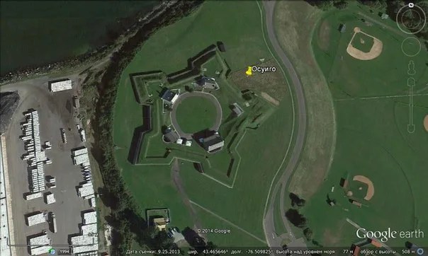
Intercession fortress, Omsk region.
 These are traces of a fort that used to be here, but which has been completely torn down, level with the ground.
 Very little can be learned about this unique object from official sources. For example, it was founded in 1752. It was built in 1752-1755. This guard fortification of the Tobol-Ishim line, located in a village on the northern shore of Pokrovsky Lake, is a historical monument.
The octagonal fortress occupied an area of 6 hectares. The fortification was strengthened with earthen sprinkling, a moat and bastions, which, like arrows, were pushed far forward, providing flanking of the approaches. The width of the ditches is 13 m, the depth is 2.5 m. On the territory of the fortress there was a powder cellar, a grocery store, officers' houses, barracks, a canopy, a stable, a pantry barn, a guard hut, a bathhouse.
At the beginning of the 19th century, with the construction of the railway, the fortress lost its military purpose.
And it's all. Who, when and why destroyed this fortress - history is silent. But there are versions from alternative history that are more like the truth than that.
Fortress of St. Anna, Rostov region, Russia.
 The fortress was founded by decree of Empress Anna Ioannovna in 1730, the construction lasted 3-4 years. Today, only large earthen ramparts and ditches, or satellite photographs, speak of this former structure.
In general, there are many such fortresses in Russia, but the only one that has survived is the Peter and Paul Fortress in St. Petersburg.

 Goryokaku Fort in the city of Hakodate on the northern Japanese island of Hokkaido.
 This is the first and largest fortress in Japan, built in 1866. At the beginning of the 20th century, it was transformed into a park, now known for its magnificent flowering cherry trees. Now, strange and incomprehensible, why was it necessary to build it in order to break it down in 50 years?
 Here are more photos of many of these interesting objects scattered around the world.

 In Germany:
 In Belgium:
 In Italy:
 Again the Netherlands:
 In Great Britain:
 Vietnam even has:
 Only now there is absolutely no information anywhere about who and when built it.
In Sri Lanka:
 It is believed that the Portuguese built in 1618.
IN THE USA:


 In Canada:
 In Mexico:
 In Brazil:
 New Amsterdam in Suriname (South America):

 But this, of course, is far from everything, but only a small part of these ingenious structures.
Disappeared ancient cities in the form of stars on the territory of Kyiv and adjacent regions.
In this article, the most interesting is the fact that the old and new maps are rotated relative to each other by about 30 degrees. Both cards are oriented towards the pole. Sometimes there are old maps that have north and south on the contrary, since on the territory of “Tartaria” another rule for the orientation of maps was adopted, when the south was displayed at the top and the north at the bottom, but there are no maps without orientation to the cardinal points. The orientation of the 1648 map gives the position of the north pole in the Greenland area. In the same direction, by the way, is oriented and St. Isaac's Cathedral in St. Petersburg :
 If on the modern map of Ukrainian cities the north is at the top (and on the old map too), then it turns out that the geographical pole has shifted. And when overlaying cards, the old . This explains why the cities are under such a layer of clay. Siberia got even more - here its layer is from 10 to 40 m /
 Took a card
Kyiv Palatinate in Latin for 1648 and superimposed it on the modern map of Ukraine with varying degrees of transparency. Download, compare. On it all the cities are in the form of stars. They were made of stone, antique. 50% of these cities no longer exist. The remains of the star ramparts can be searched using this map via google maps. But it is difficult to find, since the stars have been thoroughly erased from the surface of the earth. Many of them are at the bottom of the Dnieper reservoirs. Do not forget that all cities since then have been covered with clay by 3-4 meters. Also on the map are mountains (possibly man-made) that do not exist now. The channels of the tributaries of the Dnieper do not WIND as they do now. They are more straightforward, like the rivers in Western Europe today. Tripoli is an ancient star city just below Kyiv. Some cities slightly do not match, there is an error in the old map. He combined the cities of Kyiv and Kremenchug and took into account the channel of the Dnieper.
Took a card
Kyiv Palatinate in Latin for 1648 and superimposed it on the modern map of Ukraine with varying degrees of transparency. Download, compare. On it all the cities are in the form of stars. They were made of stone, antique. 50% of these cities no longer exist. The remains of the star ramparts can be searched using this map via google maps. But it is difficult to find, since the stars have been thoroughly erased from the surface of the earth. Many of them are at the bottom of the Dnieper reservoirs. Do not forget that all cities since then have been covered with clay by 3-4 meters. Also on the map are mountains (possibly man-made) that do not exist now. The channels of the tributaries of the Dnieper do not WIND as they do now. They are more straightforward, like the rivers in Western Europe today. Tripoli is an ancient star city just below Kyiv. Some cities slightly do not match, there is an error in the old map. He combined the cities of Kyiv and Kremenchug and took into account the channel of the Dnieper.
To understand what star cities we are talking about, read the article first, who has not read it:
Why are the channels of modern rivers winding read:
Map of 1648 in high resolution:
 Modern map:
 Overlay #1. Transparency 25%:
 Overlay #2. Transparency 50%:
 Overlay #3. Opaque:
 Those who want to practice Photoshop can overlay the map of Barklavia Palatinatus 1639 (Vinnitsa region) and Podolia Palatinatus 17th century on modern maps of these places. All cities on the maps are marked as stars.
Barklavia Palatinatus
 Podolia Palatinatus
 Ps: in order to visually represent how cities are bombarded, see the photo of an excavated house, if I'm not mistaken, in Kazan.
 Photo taken from Alexei Kungurov. He has interesting films on YouTube, by the way. For example movie
about a nuclear strike in the past.
Photo taken from Alexei Kungurov. He has interesting films on YouTube, by the way. For example movie
about a nuclear strike in the past.
The first part of this topic caused the expected discussion and interest among readers. The comments are still coming in. Some of them are very informative. Some of them revealed very interesting facts. I suggest you study them.
Coordinates 48°32"30.8"N 57°39"40.4"E (northeast of the "star" from the first part)
This is either the remnant of a star-fortress, or a built fortress wall, consisting of one beam

The moat is clearly visible, the buildings inside and nearby
Map of "stars" on the territory of Ukraine. Where are all these fortresses? It turns out that some of them can be found today.
From lena_tai
Either the "star" was so conceived and built by the rays from the river, or the river changed its course and destroyed half of the "star". If the former, then this fortress (if it is a fortress) can be very easily captured from the side of the river, and the fortress has no fortification plan in this sense.
It turns out that there are many such examples.
From athanasiykaplya : A few more unrestored forts

Boston. Georges Island. Coordinates: 42.320107° -70.927677° Link
Looks like an unfinished or underexcavated or underrestored fortress
Under these hills masonry?
Masonry of fairly large blocks adjacent to brickwork. Just like in the St. Petersburg forts. Restoration-restoration?
Is something missing here?
Entrance to the bunker

Patras (Rio), Greece 38.311257° 21.781466° link
There are only two obvious beams, the rest is somehow all built-rebuilt:

Cannes. Fort Royal, France. 43.523582° 7.044454° Link
There is clear destruction from the sea, which they tried to smooth out

Quebec 46.807969° -71.207681° link
From the side of the sea there are no reliable fortifications
From the sushi side
From the ground, the intention is hardly guessed
Someone will say that these fortresses, forts were not destroyed at all, but in the course of time they came to such a state. Somewhere dug up, somewhere reconstructed. Yes, it is possible, but many objects have an unfinished look.
Alvantara shared a file for the Google Earth program with the locations of the "stars"
One more question. Why in Europe and in other parts of the world these forts are almost perfectly preserved, and on the territory of Russia (they also exist) they are only the remains of ditches and walls, which are already only a rampart.
Let's continue on the "stars" in Russia

Fortress Kondurcha-Zakama defensive line 1734-1736. Samara Region. Link
54° 18" 5.46" N 51° 19" 55.39" E

An earlier satellite image
Do you pour it? Or do you need to dig and there will be stone blocks?

It is worth saying that between these forts there is a huge wall in its length (now just its traces):

Link
Against whom were such serious fortifications created? Prepared for the Pugachev rebellion? So there were several thousand peasants. That's funny. Or were there still much more serious forces that did not recognize the new rulers of Muscovy, the new St. Petersburg?
The name of this wall, many know: the Great Trans-Volga Wall
The distance between the "teeth" - 320m
Ditch along the wall
It is stone in places.
There are versions that these are ramparts - protection from the flood that passed from the Arctic Ocean to the Caspian Sea. Or a decrease in its subsequent seasonal effects (spring ice melt).
In the books of Fomenko and Nosovsky about the events of the "Pugachev uprising" these structures are called Siberian lines. A photo of an old map is given, where a number of fortresses and structures are marked. According to their version, it was built by the rulers of Muscovy (the Romanov dynasty) to protect against Tartaria with its capital in Tobolsk.
Pokrovskaya fortress. The size is 350 by 350 meters.
Tambov fortress. The size is 350 by 350 meters. 49°8"9.58"N 36°44"31.04"E. 49.135994, 36.741956 (on Google maps)
Boretskaya fortress (Alexeevskaya fortress). Samara region 300 by 300 meters. 49°23"31.93"N 36°15"50.35"E. 49.392203, 36.263986 (on Google maps)
Efimovsky fort. 300 by 300 meters
On the territory of Ukraine:
Oryol fortress. Ukraine, Kharkiv region, Novovodolazhsky district
49° 28" 19.91" N 35° 43" 20.91" E 230 at 230 meters
Fortress of St. John. Ukraine, Kharkov region, Krasnogradsky district, 49° 26" 28.83" N 35° 35" 8.69" E, 300 by 300 meters. Fortress of St. John (Ivanovsky Fort), belonged to the Ukrainian Line of Defense built in 1731-33, the territory of the Belevsky Infantry Regiment. Link
Fortress of St. Parascovia. Ukraine Kharkiv region, Novovodolazhsky district. 49° 31" 4.27" N 35° 52" 10.21" E, 350 by 350 meters
Fortress of St. Michael. 300 by 300 meters
Let's continue...

Vyborg. Link
The fortress is visible from the sea. It is clear from history - protection from the Swedes
60° 43" 13.41" N 28° 43" 9.06" E

Link Smolensk
It is now called the pond in the Lopatinsky garden. But everything is visible from above.
Nearby is the Smolensk fortress. Judging by the map, the wall crosses the "star" across. Was the fortress built later, using the moats of an older "star"? Officially, the fortress was built between 1595-1602 during the reign of Tsars Fyodor Ioannovich and Boris Godunov. Link
This old plan of the fortress shows that the "star" is included in the fortification of this fortress
There are even some hints that all the old cities of Russia were based on "stars". Here are some examples:

Map of the Kremlin in 1865. See the battlements on the left? And let's remember the fact: the Neglinka River. Alexander I closed it in a brick pipe. What was this reconstruction?
View of Kitai-Gorod from the ruins of the Cannon Yard. Early 19th century watercolor by an unknown artist.
Perhaps here is a remnant of the "tooth" of the more ancient "star-fortress". Even cannon open loopholes are visible
View of the bastions at the Arsenal Tower of the Kremlin. Watercolor by the workshop of F.Ya. Alekseev.
What I want to note in conclusion. As you can see, there are a lot of star fortresses on the territory of Russia. Are they all from the time of the first Romanovs or older? This is a different story. But almost all of them are destroyed, only ditches, ramparts, small ponds remain. Unlike European ones. There are more of them and the safety is better. With what it can be connected? With the fact that on our territory they were just mounds? Maybe. Practically not a single "star" has been excavated in sufficient volume. Nothing to dig? Again possible. But some doubt remains. To see photos of excavations at a similar object ...
The only more or less surviving star fortress (or rather, some of its buildings), well, except for the Peter and Paul Fortress, was dug out in Bobruisk. But more on that in the next part...
I wanted to write an article about Star Forts, a kind of star-shaped fortress, but then I decided to briefly bring the reader to the story itself, to interest and tell some facts. After all, we live in a surprisingly ancient world that began in our region.

And encircle Tartaria in a semicircle Star forts
Before we know about star forts, let's leaf through the history a little ... If you look at most Western historical and geographical sources, up to the 19th century, you can read and see some unknown country on the maps. But its territory covers a little more than half of Eurasia.

These are the territories of countries such as Finland, Mongolia, Russia and all countries that were previously part of the USSR, the countries of the Balkan Peninsula and Bulgaria, the northern territories of Korea and China. This is Great Tartaria, the successor of the country that is located beyond Borea, which we know as Hyperborea.


It was not in vain that I started so from afar, because I consider it important in my story that there was a highly developed state on the territory of Tartaria, and not, as is commonly believed or, as we are presented with, primitive and backward people. And it so happened that, in general, Russia became the successor of this civilization.


What we had and what we need to know
We did not have paganism - we believed in one single Creator God - his name is Rod, therefore the Slavs always lived in / under Rod. The Holy Spirit embraces the Genus of all things - this is the Sva Bird, and Svarog is his son. The Slavs did not worship the gods, they revered one Creator as a father, mentor and as an ancestor (Santa Claus). Much later, they began to worship epic heroes (Perun, Veles, etc.), and perhaps it was the adoption of Christianity that allowed us to preserve the ONE faith, albeit slightly changed, but very conveniently called in the old way - Orthodoxy.


Although we are now leading a new time from the Nativity of Christ, it was not Jesus who brought us a new calendar, it was a “Kolyada gift” - a calendar. However, even Pushkin still signed the dates of his works according to the old chronology, and according to them we have the 9th millennium. Even before Kievan Rus and the “new alphabet of Cyril and Methodius,” we not only had two types of writing, but the entire population was educated to read and write. And writing was used, both in public affairs and in a simple census of the population among themselves.


Now closer to the point - all the northern peoples of Russia and America, however, as in the Scandinavian myths (there is a little different, but still) have legends that white people came from the north, taught crafts and other worldly tricks and went south. Among the Vikings, the gods lived in the north, and the Greek gods, having grown fat, went beyond Borea and returned full of strength. Also, by logic, one can understand that Noah sailed from the north and split Ararat.


In India, the highest spiritual caste, the Brahmins, still put powder on their bodies to look like white teachers. In addition, many rivers and lakes in Siberia and the Kola Peninsula for some reason have Indian names. Or in India, the rivers and lakes were named after the old ... And many more echoes of some great exodus of the white race from the north can be found. And then the "Asian race" went to "their territories" from the sinking country of Mu (Lemuria or Pacifida). And behind the Pillars of Hercules (Strait of Gibraltar), between Europe, Africa and the Armericians - Atlantis and its last priest Thoth, the founder of Egypt. It is not clear where the Sumerian state that came from in finished form ...


Another not unimportant fact is that we do not have a single city where there would be a dragon on the coat of arms, well, except for Kazan, it has its own history. Serpents and dragons were enemies for us. Although, on the other hand, it was the upright Serpent who persuaded Eve to begin to comprehend the world, for which he was punished and fell on his belly, losing his legs. Here you can, just by the way, remember about the giants, these are those who were glorious people from ancient times ...


For some reason, the loopholes of the Chinese Wall look at the Chinese themselves, and in the Urals and Siberia there are many megalithic walls and other structures, the “loopholes” of which look to the west or south. And many more facts about Arkaim, the country of cities, dolmens, Arakul shikhan, Man-Pupu-Ner, Torre-Pore-Iz, Vottovaaru, Koip, etc. and so on.


And the Star Forts encircle Tartaria in a semicircle, built as if according to a pattern according to one project, but with amazing mathematical accuracy. Of course, someone may object - they say, the fortresses are not ancient, but approximately from the time of Ivan the Terrible or Vasily, but even at that time such geometry is nonsense. Here you can drag in the Serpent Shafts (serpents, serpents), and the Zavolzhskaya wall and many other architectural artifacts. What are the scale...


You may not believe all of the above, but I will be very happy if this article encourages someone to once again look into the English encyclopedia or other books and compare the facts ... A good example of star fortresses is the Peter and Paul Fortress. However, anyone who wants to can see for themselves with the help of various Internet maps the remains of earlier star fortresses.


Or maybe someone will look at Russian fairy tales differently, because only here Baba Yaga flies on a personal mortar, and Koshchei the Immortal can only be turned off from the remote control, which is in an egg, which is in a duck, etc. ... Only we have Kolobok - The earth survived all the troubles and misfortunes, but he was nevertheless deceived by the fox trader and swallowed him up. And how many legends and sayings walk through the villages, farms and villages in the outback .... Only our language explains the essence of things, and not just their visible characteristics. And now Russia, as if the state of measure, stands guard over peace and morality ...


(Using in the article such pronouns as we, ours, etc. - I mean the fraternal peoples of Ukraine and Belarus, and many other nationalities and ethnic groups, because we are all branches of the same tree - Rus' - Tartaria - Hyperborea ...)
Basalt rocks