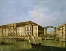
The new earth is there. The Novaya Zemlya archipelago is a picturesque corner of the Arctic
Archipelago New Earth located in the waters of the Northern Arctic Ocean between the Barents and Kara seas. In the south, across the Kara Gate Strait, there is Vaygach Island. Administratively, the archipelago is part of the Arkhangelsk region. The area of the archipelago is about 83 thousand square meters. km., and the length from the southwest to the northeast is 925 km.
The Novaya Zemlya archipelago consists of a large number islands, the largest of which are the North Island and the South Island. They are separated by the narrow strait Matochkin Shar, its width is 2-3 km. Cape Flissingsky - northeastern tip north island is the easternmost point of Europe.
The islands of Novaya Zemlya are a continuation of the Hercynian folded structures of the Urals. Intense neotectonic movements raised them to a height of more than a hundred meters, so Novaya Zemlya stands out among all the Arctic islands with its heights. In the Pleistocene all the islands were covered continental ice. The center of glaciation was located here, from where the ice slipped to the East European and West Siberian plains.
About half of the North Island is occupied by glaciers. On the territory almost 400 km long and 70-75 km wide there is a continuous ice cover, its thickness is more than 300 meters. In a number of places, ice descends into the fjords or breaks off into the open sea, forming ice barriers and giving rise to huge icebergs, whose weight can reach several million tons.
The Novaya Zemlya archipelago is dominated by a harsh, arctic climate. Winter here is very cold and long with strong winds and snowstorms. The speed of winter winds in the archipelago reaches approximately 40-50 m / s, therefore Novaya Zemlya is sometimes also called the “Land of Winds”. Frosts on the Novaya Zemlya archipelago reach 40 degrees C. The average air temperature of the warmest month - August, varies from +2.5 degrees C in the northern part of the archipelago to +6.5 in its southern part. There are many small lakes on the Novaya Zemlya archipelago, in which, under the rays of the sun in the southern regions, the water can warm up to +18.
Despite tough climatic conditions, there is life on the islands: some plant species survive here (mosses and lichens, cereal and carnation species, cruciferous flowers and some flowers like the polar poppy and cinquefoil), covering the southern coasts of the islands with sparse vegetation. Noisy bird markets nest on the rocks (herring and pink gulls, burgomasters - about 15 species of birds in total), and seals and walruses equip their rookeries under them. Earlier (24,000-19,000 years ago), large mammals also penetrated this territory (remains of mammoths were found). Now, in the south of the archipelago, only rare reindeer, lemmings, arctic foxes and wolves can be found. The owner of the territory was and remains a polar bear.
This is interesting:
- Local animal species save heat and try their best to reduce heat transfer. Many species achieve this by reducing their size: shortening their legs, ears, and beaks. And arctic foxes, it seems, pass their burrows from generation to generation (burrows have been found that are tens, if not hundreds of years old): they are incredibly difficult to dig in frozen ground, so animals do not scatter ready-made burrows.
- Cape Zemlyanoy on Schmidt Island of the Novaya Zemlya archipelago is the most remote point from the mainland: 470 km separates it from the Taimyr Peninsula.
— the Severnaya Zemlya archipelago receives the least sunny days on the planet - 12 per year, despite the fact that the polar day here lasts more than 130 days.
- The most powerful ice dome of the archipelago was passed in 2001. It provided scientists with an ice core from a depth of 724 m, which retained information for the last 8000-9000 years. The core is being studied in laboratories in Germany.
- On the island of the October Revolution and Komsomolets, glaciers formed off the coast change the coastline for more than a kilometer during the year. The record size of an iceberg was recorded here in 1953. 12 km long and about 4 km wide.
- Nina Petrovna Demme became the first Russian woman polar explorer who participated in the wintering on Severnaya Zemlya in 1932-1934, and even in the position of chief. Interestingly, two more Ninas followed her in the same direction: actinometrist (specialist in measuring the intensity of electromagnetic radiation) Nina Freiberg and meteorologist Nina Voitsekhovskaya.
- The northernmost island point of Asia is located on Severnaya Zemlya - this is the Arctic Cape on about. Komsomolets. From here to the North Pole is 990.7 km, so polar expeditions use it as a starting point.
The archipelago consists of two big islands- North and South, separated by a narrow strait (2-3 km) Matochkin Shar and many relatively small islands, the largest of which is Mezhdusharsky. The northeastern tip of the North Island - Cape Flissing - is the easternmost point of Europe.

It stretches from the southwest to the northeast for 925 km. The most north point New Earth - east island of the Greater Orange Islands, the southernmost - the Pynina Islands of the Petukhov Archipelago, the western - an unnamed cape on the Gusinaya Zemlya peninsula of the South Island, the eastern - Cape Flissingsky of the Severny Islands. The area of all the islands is more than 83 thousand km2; the width of the North Island is up to 123 km, the South - up to 143 km.

In the south, the Karskie Vorota strait (50 km wide) is separated from Vaygach Island.

The climate is arctic and harsh. The winter is long and cold, with strong winds (the speed of katabatic (katabatic) winds reaches 40-50 m/s) and snowstorms, which is why Novaya Zemlya is sometimes referred to in the literature as the "Land of Winds". Frosts reach?40 °C. The average temperature of the warmest month - August - is from 2.5 °C in the north to 20 °C in the south. In winter, the difference reaches 4.6°. The difference in temperature conditions between the coasts of the Barents and Kara seas exceeds 5°. Such a temperature asymmetry is due to the difference in the ice regime of these seas. There are many small lakes on the archipelago itself; under the rays of the sun, the water temperature in the southern regions can reach 18 ° C.

About half of the area of the North Island is occupied by glaciers. On the territory of about 20,000 km? - a continuous ice cover, stretching almost 400 km in length and up to 70-75 km in width. The thickness of the ice is over 300 m. In a number of places, the ice descends into the fjords or breaks off into the open sea, forming ice barriers and giving rise to icebergs. The total glaciation area of Novaya Zemlya is 29,767 km², of which about 92% is cover glaciation and 7.9% is mountain glaciers. On the South Island - areas of arctic tundra.
The archipelago consists of two large islands - North and South, separated by a narrow strait (2-3 km) Matochkin Shar, and many relatively small ones, the largest of which is Mezhdusharsky Island. The northeastern tip of the North Island - Cape Flissing - is the easternmost point of Europe. It stretches from the southwest to the northeast for 925 km. The northernmost point of Novaya Zemlya is the eastern island of the Bolshie Oransky Islands, the southernmost point is the Pynina Islands of the Petukhov Archipelago, the western one is an unnamed cape on the Gusinaya Zemlya peninsula of the South Island, and the eastern one is Cape Flissingsky of the Severny Island. The area of all the islands is more than 83 thousand km2; the width of the North Island is up to 123 km, the South - up to 143 km. Kli...
The archipelago consists of two large islands - North and South, separated by a narrow strait (2-3 km) Matochkin Shar, and many relatively small ones, the largest of which is Mezhdusharsky Island. The northeastern tip of the North Island - Cape Flissing - is the easternmost point of Europe. It stretches from the southwest to the northeast for 925 km. The northernmost point of Novaya Zemlya is the eastern island of the Bolshie Oransky Islands, the southernmost point is the Pynina Islands of the Petukhov Archipelago, the western one is an unnamed cape on the Gusinaya Zemlya peninsula of the South Island, and the eastern one is Cape Flissingsky of the Severny Island. The area of all the islands is more than 83 thousand km2; the width of the North Island is up to 123 km, the South - up to 143 km. The climate is arctic and harsh. The winter is long and cold, with strong winds (the speed of katabatic (katabatic) winds reaches 40-50 m/s) and snowstorms, which is why Novaya Zemlya is sometimes referred to in the literature as the "Land of Winds". Frosts reach?40 °C. The average temperature of the warmest month - August - is from 2.5 °C in the north to 6.5 °C in the south. In winter, the difference reaches 4.6°. The difference in temperature conditions between the coasts of the Barents and Kara Seas exceeds 5°. Such a temperature asymmetry is due to the difference in the ice regime of these seas. There are many small lakes on the archipelago itself; under the rays of the sun, the water temperature in the southern regions can reach 18 ° C. About half of the area of the North Island is occupied by glaciers. On the territory of about 20,000 km there is a continuous ice cover, extending almost 400 km in length and up to 70-75 km in width. The thickness of the ice is over 300 m. In a number of places, the ice descends into the fjords or breaks off into the open sea, forming ice barriers and giving rise to icebergs. The total glaciation area of Novaya Zemlya is 29,767 km², of which about 92% is cover glaciation and 7.9% is mountain glaciers. On the South Island - areas of arctic tundra. Creeping species, such as creeping willow (Salix polaris), opposite-leaved saxifrage (Saxifraga oppositifolia), mountain lichen and others, are characteristic of the scarce flora of the islands. Vegetation in the southern part is mostly dwarf birches, moss and low grass, in areas near rivers, lakes and bays a lot of mushrooms grow: milk mushrooms, mushrooms, etc. big lake- Goose. It contains freshwater fish, in particular char. Of the animals, arctic foxes, lemmings, white partridges, and also reindeer are common. Polar bears come to the southern regions with the onset of cold weather, being a threat local residents. Marine animals include harp seals, seals, bearded seals, walruses, and whales. On the islands of the archipelago you can find the largest bird colonies in the Russian region of the Arctic. Guillemots, puffins, seagulls settle here. On September 17, 1954, a Soviet nuclear test site was opened on Novaya Zemlya with a center in Belushya Guba. The landfill includes three sites: Black Guba - was used mainly in 1955-1962. Matochkin Shar - underground tests in 1964-1990 D-II SIPNZ on the Dry Nose Peninsula - ground tests 1957-1962. In addition, explosions were also carried out at other points (the official territory of the test site occupied more than half of the entire area of the island). From September 21, 1955 to October 24, 1990 (the official date of the moratorium on nuclear testing), 135 nuclear explosions were carried out at the test site: 87 in the atmosphere (of which 84 air, 1 ground, 2 surface), 3 underwater and 42 underground explosions. Among the experiments were very powerful megaton tests of nuclear charges, carried out in the atmosphere over the archipelago. On Novaya Zemlya in 1961, the most powerful hydrogen bomb in the history of mankind was detonated - the 58-megaton Tsar bomb at the D-II "Dry Nose" site. The shock wave resulting from the explosion circled the globe three times, and on the island of Dixon (800 kilometers) the windows in the houses were blown out by the blast wave. Only Novaya Zemlya With an ostentatious lesson She convinced me to live not in vain, But with intelligence and use. From a poem by V. G. Amazonov.
And that same morning at 11:32 a.m. over Novaya Zemlya at an altitude of 4000 m above the land surface, a bomb with a capacity of 50 million tons of TNT was exploded.
The light flash was so bright that, despite the continuous cloudiness, it was visible even at a distance of a thousand kilometers. The swirling giant mushroom has grown to a height of 67 km. By the time of the explosion, while the bomb was slowly descending on a huge parachute from a height of 10,500 m to the calculated point of detonation, the Tu-95 carrier aircraft with the crew and its commander, Major Andrei Egorovich Durnovtsev, was already in the safe zone. The commander returned to his airfield as a lieutenant colonel, Hero of the Soviet Union.
Slavsky and Moskalenko, being congress delegates, specially flew to the northern test site early in the morning on the day of the experiment to observe the preparation and implementation of the explosion. From a distance of several hundred kilometers from the epicenter, being on board the Il-14 aircraft, they saw a fantastic picture. The impression was completed by the shock from the shock wave that overtook their plane.
One of the groups of participants in the experiment, from a distance of 270 km from the point of explosion, saw not only a bright flash through protective tinted glasses, but even felt the effect of a light pulse. In an abandoned village - 400 km from the epicenter - wooden houses were destroyed, and stone houses lost their roofs, windows and doors.
For many hundreds of kilometers from the test site, as a result of the explosion, the conditions for the passage of radio waves changed for almost an hour and radio communications ceased. Those who were at the airport Kola Peninsula near Olenya, the creators of the bomb and the leaders of the experiment, headed by the chairman of the State Commission, Major General N. I. Pavlov, for 40 minutes did not have a clear idea of what happened and in what condition the crews of the carrier aircraft and the laboratory aircraft accompanying it Tu-16. And only when the first signs of radio communication with Novaya Zemlya appeared, from the command post near Olenya, they asked in plain text for information about the height of the cloud's rise. In response, they reported: about 60 km. It became clear that the design of the bomb had not failed.
In the meantime, the crews of the two planes taking off on a mission, and the documentary filmmakers who were filming at other points, experienced, by the will of circumstances, the most vivid and strong impressions. Cameramen recalled: “It’s creepy to fly, one might say, riding a hydrogen bomb! What if it works? Although it’s on fuses, it’s still ... And there won’t be a molecule left! Unbridled power in it, and what! The flight time to the target is not very long , but it stretches... We are on a combat course. The bomb bay doors are open. Behind the silhouette of the bomb is a solid cotton wool of clouds... And the bomb? Pilots in afterburner leaving the drop point... Zero! Under the plane from below and somewhere in the distance, the clouds are illuminated by a powerful flash. What an illumination! Behind the hatch, light-sea simply spilled out, an ocean of light, and even the layers of clouds were highlighted, manifested. .. At that moment, our plane left between two layers of clouds, and there, in this hole, from below, a huge light-orange balloon appears! It, like Jupiter - powerful, confident, self-satisfied, - slowly, silently creeps up .. Breaking the hopeless, it would seem s, cloudiness, it grew, everything increased. Behind him, as if into a funnel, it seemed that the whole Earth would be drawn in. The spectacle was fantastic, unreal ... in any case unearthly "
And meridians 51°30` and 69°0` east longitude from Greenwich. This land belongs to the Arkhangelsk region. Undoubtedly, it is ranked by scientists among the islands of the mainland.
The two main islands are separated by a narrow, winding Strait Matochkin Shar. Of a number of small islands, the largest is Mezhdusharsky Island. Novaya Zemlya serves as the western boundary. From the south, it is washed by the waters of the Kara Gate Strait, which separates it from the island. From the west and northwest it is washed by the Murmansk and Arctic Oceans. Within these limits, the two islands form an arc, slightly curved and bulging towards the west. Since the northern part of Novaya Zemlya has not yet been surveyed, and even the position of its northern extremity cannot yet be finally established, the total length and area cannot yet be precisely given. Its length is about 1000 km. The greatest width is not more than 130 km. The area is approximately 80,025 square kilometers. From this number to south island accounts for 35,988 square kilometers, and the northern 44,037 square kilometers. Mezhdusharsky - 282 square kilometers. All the rest are about 290 square kilometers.
The length of the coastline of Novaya Zemlya is about 4400 kilometers. The southernmost point is Cape Kusov nos, located on the island of Kusova Zemlya, separated from Novaya Zemlya by the Nikolsky Shar Strait. From this point, the ocean coast goes to the west, and the sea coast to the east. The ocean coast is characterized by a large indentation of the coast, forming here a huge number of bays, peninsulas and islands. The southernmost part of the coast is indented by smaller bays. The first significant bay is the Sakhanikha Bay (between 55 - 56 ° east longitude). One of the large Novaya Zemlya lip Sakhanikha flows into the strait. Further to the west is the Chernaya Bay strait, which extends far into the island for 30 kilometers. The western and north-western direction of the coast is preserved up to Cape Cherny, starting from here, the coast turns directly to the north, and then to the north-west. It forms a vast bay between Capes Cherny and Yuzhny Goose. It has indented shores. Here is located the largest of the skeletons of Novaya Zemlya - Mezhdsharsky. It is separated from the coast of Novaya Zemlya by the Kostin Shar strait, into which one of the most significant rivers of Novaya Zemlya, the Nekhvatov, flows. The length of the river is 80 kilometers. To the north of Mezhdushary Island there are two large bays: Rogachev and Belushya Bay.
Starting from Cape South Goose Nose, coastline goes almost along the meridian, without forming any significant bays up to Cape North Goose Nose. This part of the coast, 100 kilometers long, is the westernmost part of Novaya Zemlya. It is called Goose Land. Farther north, between Cape Goose Nose and Razor Nose, is Moller Bay, which in turn is indented by many coastal depressions, which form good moorings for ships, together with places lying near the islands. Here, in the bay of Malyye Karmakul, there has been a camp for a long time, where several families of Samoyeds live in winter and summer. In the north, Moller Bay ends with a deep-lying Pukhov Bay, into the top of which the Pukhovaya River flows. Further flows the river Britvinskaya. To the north of Cape Britvin there are two large bays: the southern one - the Bezymyannaya Bay and the northern one - the Mushroom Bay, separated by a high bay from Pervousmochennaya Mountain. Further to the entrance to the Matochkin ball, the coast is flat and rocky. The entrance to the Matochkin ball presents some difficulty, since one can easily mistake for it the Silver Bay lying a little to the north. However, signs have already been placed to facilitate entry into this bay.

Following on west bank further north, we meet Silver Bay, surrounded by high mountains. Next are the lips of Mityushikha and Volchikha. They are located in a deep recess between the shore of Novaya Zemlya and Cape Sukhoi Nos. From the Dry Nose to another prominent place - the Admiralty Peninsula - the coast of Novaya Zemlya is again indented with bays. The largest of them, starting from the south, is Krestovaya Bay with several islands. Two bays of Sulmenev enter here - northern and southern - and Mashigin Bay. There are many bays from the Admiralty Peninsula to the Gorbovy Islands. There are several islands here: Pankratiev, Wilhelm, Krestovy and others.
Further, the coast gradually deviates to the east - to Cape Nassau. East Coast does not have as many deep bays and peninsulas protruding into the sea as the western one. Starting from the south of Kusov Nose, the coast turns to the north. Here is the extreme southeastern part of Novaya Zemlya, Cape Menshikov. From here, the coast of Novaya Zemlya gradually recedes to the west, almost without bays, to Abrosimov Bay, which lies slightly south of 72 ° north latitude. The Abrosimova River flows into it. From the Gulf of Abrosimov, the coast of Novaya Zemlya takes the direction of the north and north-east. Here it becomes more indented up to the very Matochkin ball. From here, to the north, the coastline becomes more indented and forms in places quite significant bays, the largest of them: Chekina, Neznaniy, Medvezhiy. To the north of which lies the Krasheninnikov Peninsula and the Pakhtusov Islands (74°25` north latitude). Further, Pakhtusov discovered Cape Dalniy, lying slightly south of 75 ° north latitude. From where to Cape Middendorf the coast is almost unknown. Behind it to the north lies Ice Harbor Bay, where the Dutchman Barents wintered in 1598. Further, the coast of Novaya Zemlya rises straight along the northern meridian to Cape Zhelanie. Novaya Zemlya was first discovered by the Novgorodians, probably in the 11th century. But the first written data about it are found in the edition of Hakluyt: "The principal navigations, Voyages and Discoveries of the English Nation" (London, 1859). Here is described the first journey of the English, under the command of Willoughby, east of the North Cape, in search of a northeast passage into