Bakla Crimea how to get by car. Bakla - the northernmost cave city of Crimea
The cave city of Bakla is one of the most beautiful and famous places peninsulas of Crimea. His settlement is located 18 km from the city and is located in the southern part of the Inner Range. In these places, the mountain ridges are rocky and steep.
In this place you can see how nature has gradually changed due to human influence over many centuries. An example is the sculptural works that were created by genius architects. A forty-meter sphinx is carved into the mountain.
A little further and lower one can see cell rows representing examples of honeycomb-type rock slopes. The beauty of the landscape is given by small and large niches, cherry bowls interspersed with hawthorn, amazing glades, and of course fifteen species of orchids.
Here you can see the surviving fortifications of Bakla, which are located on the hills, their height reaches three hundred meters. This fortification existed in the 4th-7th centuries, and was destroyed by nomadic Tatars. Artificial caves, of which there are more than a hundred, have survived to this day.
The Baklinsky necropolis is another example of late antique traditions that lived out their era at the dawn of the Middle Ages. 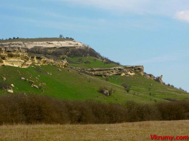
Cave cities have brought their medieval appearance to our days, because. were not distorted by late construction. After all, the inhabitants at one time simply left them, moving to the valleys, more comfortable for life.
Bakla is located at an altitude of 470 m above sea level, on a flat terrace at the foot of Mount Bakla, inside a kind of triangle bounded from the west and east by limestone ridges, and from the south by a steep plateau up to 12 m high.
To get to Bakla, you need to go along the highway to Novopavlovka, then turn onto the road leading to the village of Nauchny, where the Crimean Astrophysical Institute of the Academy of Sciences of Ukraine is located (the largest Crimean Astrophysical Observatory in Ukraine).
Behind the village of Skalisty we get on a dirt road to the left to the southeast. She goes through a small forest and an orchard, leads to the crest of one of the heights of the second mountain range, where the remains of the medieval settlement of Bakla are located.
You can also go to Baklu from the village of Skalisty through the territory of the (Bodrak) quarry or, having passed it, immediately turn left to the east onto a country road and continue along a shallow valley. On the left, sheer cliffs rise, on the right, on a sloping slope, a sparse forest grows. Seeing numerous artificial caves in the rocks, consider that you are at the goal.
On the territory of Bakla, in some places you can see the former streets and alleys, traces of houses, small chapels, graves carved into the rock, the remains of crushed grapes, numerous round and rather deep utility pits, many artificial caves.
 Archaeological excavations on the southern cliff revealed the remains of a fortress wall and a tower, behind which there used to be internal outbuildings. At the end of the 3rd - beginning of the 4th centuries, the fortification formed a single whole with the rest of the village. There was a wine-making complex here, the utility pits of which are clearly visible at the eastern moat of the castle. Later, believed to be in the 6th century, a castle was built on the hill. Its fortifications were built of large blocks of local limestone on lime mortar.
Judging by the finds, the fortress perished at the end of the 13th century, apparently during the Mongol-Tatar invasion.
On the western outskirts of Bakla, the remains of a large church and crypts carved into the rock have been preserved. And above this church complex in the overhanging ledge of the rock is a small cave church. In the valley visible from Bakly, where the collective farm fields are now, there was a village in the Middle Ages. Fragments of large clay pithoi are often found here; the remains of a pottery kiln were found in the eastern part. To the south of this place in 1970 a burial ground with burials of the 7th-13th centuries was discovered.
Bakla is a characteristic medieval feudal complex: a castle with an adjoining settlement and a rural settlement. This interesting archaeological monument was first explored by the employees of the Crimean Museum of Local Lore in 1929, and since 1961 it has been studied by the researchers of the State Historical Museum(Moscow).
2016-11-06 The cave city of Bakla is one of the first fortifications of the Byzantine Empire in the vicinity of Bakhchisaray.Geographical coordinates of the cave city of Bakla on the map of Crimea GPS N 44.811775 E 34.004710
Today cave city bakla, works like a museum under open sky. Its visit is free, but if you decide to take a guide, the price of a visit can range from 1000 to 2000 rubles. from the group. A walk from the village of Skalistoye to the top of the Bakly plateau, on average, takes 3-5 hours. This is a time with halts, photo stops and climbing at a measured pace.

The cave city of Bakla is a monument ancient architecture and protected by the state. The territory of the city is about 2.1 hectares. The city was built in two tiers. The first tier served to protect the city. There were fortifications here. The second tier was residential. The main part of the premises is carved into the rock, and in fact, is a cave. But in the Middle Ages, there was a small castle on the territory of Bakla, there was a fortress wall and additional defensive structures.

On the territory of Bakla there were two temples, one cave, its remains can be seen today. The second was built of stone on a plateau. All that was left of it was the foundation. On the territory of the cave city of Bakla, today you can see not only caves, but also many advanced, at that time, utility rooms: stone pits for collecting water (there are no springs on the mountain), stone pits for storing grain and stone wineries. Excavations in Buckle were carried out twice in 1929 and in 1961, but they were rather superficial and looked more like a study of the area, with a selective deepening of 20-40 cm into the ground. Full-scale studies on the territory of the cave city have never been carried out.

The first name of the city has not survived to this day, and the name Bakla appeared in the Middle Ages and was given by the Turks. Not far from the city, at a distance of 1 km, an ancient burial site dating back to the 6th century AD was found. It was on the basis of the items found in the crypts and graves that the life of the city of Bakla was partially reconstructed. Almost all the finds from the burials were given to the Bakhchisaray Museum of Local Lore.
In addition to the beauty of the cave city, tourists are attracted to these places by another interesting fact. On the territory of the city, from the very beginning of the hill to the very plateau, in the exposed rock, one can observe a large number of fossils of marine inhabitants of the Crimea. These fossils were formed 50-60 million years ago. In those days, the Crimea was the seabed, and in confirmation of this, in the rock, you can find fossils of ancient mollusks, crabs, many shells and other inhabitants of that era. In general, this beauty must be viewed on the spot, it is very difficult to express this pleasure in words.

The history of the cave city of Bakla.
The history of the city of Bakla began in the middle of the third century AD. The Byzantine Empire strengthened its positions in the Central Crimea and began building a series of fortifications that were supposed to stop or at least complicate the invasion of nomadic tribes, who often made their way to the Crimea from the mainland. In the 5th-6th century, the cave city of Bakla turned from a small outpost into fortified fortress. A small garrison appears in the fortress and the city begins to develop. By the 7th-8th century, the city has about a hundred houses. The main part was carved in stone and for the most part were caves.

In addition to houses, a small cave temple appears, develops Agriculture and there are vineyards. The main development of the city fell on the 10th-12th centuries. It was this time that can be considered the heyday of Bakla. Very little is known about the life of the city, but according to the finds made in 1961, it can be judged that trade was developed with practically all the large cities of the Crimea of that time (Kerkinitida (Evpatoria), Chersonesos (Sevastopol), Kafaa (Feodosia) and others. The heyday of the city of Bakla was interrupted by the invasion of Nagai, in 1299, under the onslaught of nomadic tribes, Bakla was plundered and destroyed, like almost all the cave cities of the central Crimea.After the invasion of Nagai, the history of the city is not known.

How to get to Bakla Cave City
Get to Buckle the easiest is from or . Between these cities is the village of Postal. Here you need to move off the main road towards the village of Skalistoye. Almost at the very exit from the village, you can leave the car and start climbing to the cave city. There are several trails leading to Bakla, but each leads to the top of the plateau, and the difficulty of the trails is approximately the same. This makes it almost impossible to get off track.
The cave city of Bakla is one of the many cave cities of the central Crimea and one of the unique ones. A visit to Bakla is very often included in walking tours around the Crimea.
The ancient settlement of Bakla, 2 km from the village of Skalistoye on the slope of the mountain of the same name, is the northernmost cave settlement of Crimea.
Organized tourist routes to it are quite rare, and Bakla can rightly be called a lost city.
The first people settled on Buckle at the end of the 3rd century, using natural voids in limestone rocks. In the VI century, elevated buildings appeared on one of the ledges of the mountain, rising 470 m above sea level. A triangular plateau with an area of approximately 1 hectare is protected from the north by an upper step, from the south, the safety of the settlement from enemy raids was ensured by a steep cliff over the abyss and a citadel built along it to protect the city from external intrusions.
There are three roads leading to the settlement - the main one, the southern one, through a cut in the cliff. To the right of it is a granary of multiple artificial caves, carved into the rock and shaped like eggplant vessels. Probably, the name of the settlement is associated with grain pits, although many historians claim that “bakla” in translation from the Crimean Tatar means “beans”. The holes in the pits were covered with lids and smeared with a special solution to prevent precipitation from getting inside. Above the cave-pits, rectangular clearings are hardly visible, probably intended for burials.
To the east, from the central entrance to the city of Baklu, one can see the remains of the fortifications of the citadel, towers and the ruins of a structure that looks like the dwelling of someone richer than the poor townspeople. An entrance to a tunnel connecting the fortifications with city buildings was also found here. Near the entrance to the tunnel are the remains of a cave temple complex. The best-preserved part is the altar niche of one of the temples, framed by a modest rim in the form of grooves; the foundation of a land-based basilica was excavated nearby.
In the western part of the settlement there are utility caves with characteristic ears for tying cattle. The sewer, carved into the yellowish limestone, was intended to drain spring water from a dried-up source.
A little higher up the slope, to the west of the settlement, a compact cave complex, presumably for religious purposes, was discovered, perhaps a monastery, a little further away - the remains of cult burials.
Judging by the number of grain pits - more than 150 - and several tarapans, it can be concluded that the main occupation of the townspeople of Bakly was agriculture, including the cultivation of grain and winemaking, as well as animal husbandry.
The cave city of Bakla has not been fully explored to this day, the upcoming excavations will reveal a lot of interesting information about life. medieval Crimea.

Attractions near Bakla
For lovers of antiquity, other cave settlements of the Bakhchisarai region will also be of interest.
Chufut-Kale- a fortress city on the border of the Byzantine possessions in the Crimea, which arose in the 5th century, is also known as Kyrk-Er, given by the Kipchaks, who conquered these places by the end of the 13th century. By the beginning of the formation of the Crimean Khanate, the main population of the city was the Karaites, who built temples - kenasses, estates, a mint. Currently, representatives of the ancient people are restoring temple structures, there is an exposition in the preserved premises, which tells about amazing story cities.
Mangul-Kale- the capital settlement of the Principality of Theodoro, which withstood the onslaught of the Tatars and the Genoese in the XIII century and fell only under the onslaught of the Turkish army, which took the city by a six-month siege. To this day, many urban buildings have been preserved - casemate caves, temples with curious wall paintings, residential buildings that are interesting for inspection.
Eski-Kermen- translated from the Crimean Tatar "old fortress", a monumental monument of the medieval Crimea, built by the Byzantines as a defensive fortress, inhabited by more than 2 thousand inhabitants. Killed by the invasion of the Tatars. Today it is a historical and cultural reserve, interesting object for excursions, presenting for inspection cave temples, a fortress, a siege well, elements of a basilica.
Kyz-Kermen- "maiden's fortress", a settlement of about 100 inhabitants, with several tarapanas for winemaking, cave-rooms. Away from the buildings, to this day, a spring flows in the Turtle grotto, most likely, it fed the inhabitants of the ancient settlement with water. Nearby, a reservoir resembling a pool is carved in stone. There are no signs of conquests here, it seems that life in Kyz-Kermen faded away gradually.

Where to stay to visit Bakla
Nearest locality from the cave city of Bakla - the village of Skalistoye, in which there is no tourist bases or hotels. You can stop by agreeing with local residents about renting housing, for about 500-600 rubles per day.
There is a camp site for cyclists in Trudolyubovka and a Skif hotel in Novopavlovka at prices ranging from 1100 to 1800 rubles. You can visit Bakla while relaxing in Bakhchisarai or Simferopol.
How to get to Bakla
Russia, Crimea, Bakhchisarai district, s. rocky
A regular bus runs to Skalisty from Simferopol from the Zapadnaya bus station with the destination Simferopol-Scientific. A distance of 18 km is overcome in a third of an hour, the ticket price is 20 rubles. By their own vehicles, they drive along the Sevastopol-Simferopol highway to the turn in Novopavlovka at the sign "Scientific", the next village is Skalistoye.
An option is possible - by electric train to the Pochtovaya station, then 2 km on foot to Novopavlovka, boarding a bus to Nauchny.
Transfer from Anapa to Simferopol via Kerch Strait- 350 rubles, from Krasnodar - 750 rubles.
The early medieval cave complex of Bakla is located southeast of the village of Skalisty. You can get to it either by train from Simferopol to the Pochtovaya station, then on foot along the highway to the village of Skalistoye, or from Simferopol to Skalisty by bus, then from Skalisty along the highway in the direction of the village of Nauchny. Behind the bridge, the highway on the left side nestles against the slope of the cliff, under which a couple of residential buildings nestled. At the foot of the cliff, a grotto called Shaitan-Koba (Devil's Cave) is visible. On the far side, in the Mousterian archaeological era, in a small natural grotto with a depth of about 4 m, a group of Neanderthals, the predecessors of Homo sapiens, found shelter.
After walking a little more along the highway, then you need to turn left, following the country road. On the right there will be a small clearing, and on the left a rocky ridge rises above which the Soviet man "worked", the slopes are strewn with sawn-off rock fragments. Then you can go all the time along the road, soon a stone crusher will appear on the right, after which you need to go along a dirt road that runs along the edge of the field, along the forest edge, or you can, turning earlier towards the rocks, go along the beam and terraces of the rocky ridge, through the bush, along rocks. On this path, there are fragments of rocks with caves, here you can admire the beauty of the rocky ridge and the approaching complex of the Baklin settlement, which are not visible due to the forest edge if you walk along a dirt road.
Bakla - this interesting archaeological monument was first explored by the staff of the Crimean Regional Museum in 1929. The appearance of the cave city is attributed to the second half of the 3rd century AD.
If you climb the path to the caves located to the west, among the deep silence you hear the sound of measuredly dripping drops - this is in a break in the rock from above, from a cliff, water seeps in thin threads from a source located somewhere higher, in the thickets. The trail along the rocks, past the caves leads to the plateau. Far from its edge rises the second tier. Moving east along the plateau, traces of the life of a long-abandoned city are noticeable: household pits, water collection tanks, gutters, tarapanas (grain presses), grain pits, steps to caves, graves. Many artificial caves have been preserved everywhere. The terrace is covered with feral fruit trees - the remains of gardens.
On the southern edge rocks, dominating over a narrow valley, in a very small area there are the remains of a fortification. Excavations have shown that the defensive walls cover layers dating back to the time of the open settlement, the fortification area was a single whole with the rest of the village. Here in the III-IV century. there was a significant settlement. The population - Sarmatian-Alans, partly Goths - was engaged in viticulture, horticulture, agriculture, and winemaking. The earliest belt of defensive walls was built in the 5th century. Later, as it is believed, in the 6th century, a castle was built here. Its fortifications were built of large blocks of local limestone on lime mortar. The fortified settlement was destroyed, probably, during the Tatar raid in 1299.
The citadel was surrounded on three sides by walls made of hewn limestone blocks. During the life of the settlement, the citadel was rebuilt at least three times. Remains of a rectangular gate tower were found in the northern corner of the citadel. For the construction of defensive walls, the surface of the rock was hewn. Outside the fortification was the building of the basilica, which burned down around the 10th century.
The southeastern flank of the battle walls ends at a cliff, on the edge of which there was a structure that closed the defense - a tower or a combat platform with a parapet.
The area was built up quite densely. The remains of 2 houses were found here, one of which consisted of 8 rooms and had 2 floors. The lower, non-residential, was deepened into the rock, on the surface of which there are cuts for wooden pillars and vessels.
"In the western part of the cave settlement, in the upper tier, almost at the level of the ridge, there is a ledge of rock, separated from the ridge by a crack: a church is carved in this ledge. The doorway faces north, a step leads down, the interior is divided into two parts, the smaller one is the altar - a little lower; small recesses are carved in the altar, it is separated from the rest of the space by an iconostasis, judging by the grooves hollowed out in the walls. Opposite the altar is a window; immediately at the entrance, two crosses are carved on the wall to the left." - you can find such a description of the church in most sources, but you will not be able to find the temple itself according to this description, because it collapsed and you can find it on the slope, doorway up.
There are a lot of battle caves in the western part of the settlement, some of them were accessed from the surface with hatches, others with stairs carved into the rock.
Where the upper cliff of the ridge recedes far from the edge of the terrace, it is easy to climb it, and going east to the very high point, take a look around. At the foot of the cliff there is a valley and fields, on the left you can see the majestic Chatyr-Dag on the horizon, on the right - the slender silhouette of Tepe-Kermen and the Chufut-Kale plateau.
There was a village in the valley visible from Bakly in the Middle Ages. Fragments of large clay pithoi are often found here; in its eastern part, the remains of a pottery kiln were found. To the south of this place, on the slopes of a ravine called Durnoy Yar, a burial ground with burials of the 7th-8th centuries was discovered. Unfortunately, this necropolis is almost completely plundered.
Here, on a hillock, there was a temple, the remains of which were found during excavations. It was built over a burial crypt, laid out of well-hewn stone slabs, on which scratched images of people, horsemen, signs of Turkic, runic writing have been preserved.
Information
photo from the site