What about places of recreation for the population. Greening cities in Russia (Yuskevich N.N., Lunts L.B.)
Places country rest and tourism as objects of architectural and landscape design are particularly complex due to their close connection with the tasks of nature protection, the need to take into account many factors of planning, sanitary and hygienic, social orders at the highest scale urban planning levels.
A recreation area, or a recreational area, is a territorial formation with an area of several tens (rarely up to several hundred) square kilometers, including separate recreation areas, complexes of recreational institutions and devices and having a single planning organization, service system, transport, engineering and technical support. They, as a rule, are formed near cities to meet the needs of their population for short-term and partially long-term rest. The leading factor in the placement of recreation areas is the availability of appropriate recreational resources, i.e. suitable natural and landscape conditions - forest areas, rivers and lakes.
The most visited recreation areas, located directly near (up to 5 km) from cities, are distinguished by an increased level of improvement, which allows the landscape to withstand high recreational loads. Zones located at a considerable distance from the city, on the contrary, may have simplified amenities, somewhat closer to the natural environment. If on the "threshold" of the city such recreational areas as parks and forest parks, short-term recreation areas near water bodies, sport complexes, then in the more remote zone of the suburban zone there are places of rest with lodging for the night (bases and recreation towns, gardening associations, etc.). Finally, in the most remote parts of the suburban areas, objects of long-term recreation are located (pioneer camps, dachas of preschool institutions, boarding houses, recreation centers of enterprises - usually surrounded by forests, near water bodies).
Mass short-term recreation areas that require the transportation of a large number of vacationers during weekend peak hours are located within walking distance from railway stations, subway departure lines, bus routes, water transport stops. Within the boundaries of the zones, it is necessary to ensure the alternation of intensively and extensively used territories, in which the complex of the original (or restored) is preserved with the greatest possible completeness. natural conditions. Service centers around which the territory of intensive development is being formed should be located at a distance of approximately 2...3 km from each other so that the width of the extensive development strip is at least 1.5 km. In view of the fact that vacationers use the edges of forests that go directly to water bodies most intensively, the degree of improvement in landscaped coastal strips up to 150 m wide should approach the park and provide loads of up to 30 people / ha. Here a dense network of roads and paths with a hard surface is created, lawns are formed, clumps of trees and shrubs are formed, benches, urns, drinking fountains, outdoor lighting lanterns, and shady canopies are placed. Within the beaches - grassy and sandy - the load can be 100 and 1000 people / ha, respectively (approximate width of the beach strip is 30 ... 60 m). Long-term recreation zones have a more complex structure: in them, individual recreational facilities are grouped into complexes, and complexes are grouped into groups of complexes that are at least 2–3 km apart from each other with gaps filled with forest parks. This makes it possible to avoid the appearance of vast areas of continuous recreational development, which depresses the majority of vacationers and poses a threat to the ecological balance of the natural environment.
Based on the analysis of the most successful examples of design and construction practice, the following types of development in recreation complexes can be recommended:
a group of one-story bungalows or one-, two-story pavilions. Group size 80...100 block cells or 8...12 pavilions, group capacity 150...400 seats; building site 5...6 ha; load on the site 30 ... 70 people / ha (Fig. 6.1);
a group of two-, three-, five-storey buildings with a compact plan. The number of buildings is 3...6, the capacity of the group is 400...800 people, the building area is 5...9 ha, the load on the site is 70...100 people/ha;
a group of six-, nine-story buildings with a compact plan. The number of buildings is 3...5, the capacity of the group is 800...1000 places, the building site is 8...9 ha, the load on the site is 100...120 people/ha.
 |
| Rice. 6.2. A fragment of a recreation area on the Zaslavsky reservoir near Minsk. Coastal meadow park: 1 - buildings; 2 - inputs; 3 - entrances; 4 - parking lot; 5 - service centers and settlements; 6 - beaches; 7- Railway; 8 - highways; 9 - park road; 10 - walking pedestrian roads; 11 - tree and shrub massifs; 12 - meadows; 13 - reservoirs; 14 - the main service center for vacationers; 15 - sub-center for servicing vacationers; 16 - sports zone; 17 - "Upland Park"; 18 - meadow parks; 19 - beaches; 20 - a zone of quiet rest; 21 - historical and memorial center; 22 - country hotel; 23 - stage; 24 - dance floor; 25 - cafe; 26 - base of fishermen; 27 - decorative pool; 28 - channel; 29 - Nature and Fantasy Park; 30 - "Swamp Garden"; 31 - Bay "Fishing happiness"; 32 - "Chamomile Meadow"; 33 - "Alpine Hill"; 34 - "Heather Glade"; 55 - road "Rainbow"; 36 - tower "Vezha" |
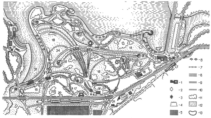
However, the size, functional organization, architectural and landscape appearance, planning structure of recreation areas located in various natural and urban conditions are extremely diverse and are difficult to strict standardization or typification. As an example, consider one of the most famous suburban recreational areas, which was formed near the artificial Zaslavsky reservoir near the northwestern borders of Minsk (Fig. 6.2). This zone is a continuation of the urban water-green diameter, formed on the banks of the dammed river Svisloch, and covers an area of 16.5 thousand hectares. The natural environment here was favorable for the creation of places mass recreation: a fairly large water area of the reservoir (3 thousand hectares) with a rugged coastline, it is partially adjoined by pine and deciduous forests (30% of the total area of the zone), many flowering meadows, and beaches.
For the first 10...15 years (starting from 1952), this recreation area developed without taking into account the long-term prospects for the development of the entire recreation system of the city's population, without a scientific study of the natural situation and calculation of the probable recreational load on landscape complexes. Due to insufficient attention to the environmental side of construction, a number of adverse changes have occurred here. A large number of vacationers appeared in those parts of the forest that adjoin the banks, which caused their degradation. Natural beaches have fallen into an unsanitary state, and several small equipped beaches have also been unable to withstand the excessive load. The water bloomed in the bays of the reservoir, as its bed was not cleaned. Pioneer camps and other institutions with large fenced areas began to interfere with those who come here for a short vacation. In 1969, the Minskproekt Institute developed a project, an important part of which was a detailed assessment of natural landscapes, a forecast of their possible changes for the future. The developed planning concept was based on the analysis of the physical-geographical, hygienic, natural-historical, aesthetic characteristics of the current situation.
Additional watering of the reservoir from the basin of the river was designed and implemented. Neman, which led to an improvement in the water regime of all water areas of the zone. A regime for the protection of soil cover, forests and small watercourses has been established. New beaches were organized to reduce the recreational load on the previously developed sections of the reservoir shore. Cultural and community services are now provided through a system of special centers and sub-centers, conveniently connected to transport and pedestrian areas. Based on the calculation of the one-time capacity of the recreation area, all its constituent elements are developed: a meadow park, a hydropark, forest parks, beaches and the local resort Zhdanovichi. The previously poorly developed western and northwestern sections of the reservoir (beaches, yacht clubs, sports bases, a rowing canal, a forest park, etc.) are being improved. The new meadow park on the previously swampy southern coast (closest to the city) performs an “intercepting” function, regulates the flow of tourists and thereby relieves excessive pressure on pine forests. The meadow park includes an extensive “chamomile meadow”, “heather meadows”, a “marsh garden” with weeping willows, birch groves - landscapes characteristic of this part of Belarus.
K category: landscape design
Out-of-town public recreation areas. forest parks and protected landscapes
Places of country recreation and tourism as objects of architectural and landscape design are particularly complex due to their close connection with the tasks of nature protection, the need to take into account many factors of planning, sanitary and hygienic, social orders at the highest large-scale urban planning levels.
A recreation area, or a recreational area, is a territorial formation with an area of several tens (rarely up to several hundred) square kilometers, including separate recreation areas, complexes of recreational institutions and devices and having a single planning organization, service system, transport, engineering and technical support. They, as a rule, are formed near cities to meet the needs of their population for short-term and partially long-term rest. The leading factor in the placement of recreation areas is the availability of appropriate recreational resources, i.e., suitable natural and landscape conditions - forests, rivers and lakes.
The most visited recreation areas, located directly near (up to 5 km) from cities, are distinguished by an increased level of improvement, which allows the landscape to withstand high recreational loads. Zones located at a considerable distance from the city, on the contrary, may have simplified amenities, somewhat closer to the natural environment. If on the “threshold” of the city such recreational areas as parks and forest parks, short-term recreation areas near water bodies, sports complexes predominate, then in the more remote zone of the suburban zone there are places of recreation with overnight stays (bases and recreation towns, gardening associations, etc.). Finally, in the most remote parts of the suburban areas, long-term recreation facilities are located (pioneer camps, dachas of preschool institutions, boarding houses, recreation centers of enterprises - usually surrounded by forests, near water bodies).
Mass short-term recreation areas that require the transportation of a large number of vacationers during weekend peak hours are located within walking distance from railway stations, subway departure lines, bus routes, and water transport stops. Within the boundaries of the zones, it is necessary to ensure the alternation of intensively and extensively used territories, in which the complex of initial (or restored) natural conditions is preserved with the greatest possible completeness. The service centers around which the territory of intensive development is being formed should be located approximately at a distance of 2–3 km from each other so that the width of the extensive development strip is at least 1.5 km. In view of the fact that vacationers use the edges of forests that go directly to water bodies most intensively, the degree of improvement in landscaped coastal strips up to 150 m wide should approach the park and provide loads of up to 30 people / ha. Here a dense network of roads and paths with a hard surface is created, lawns are formed, clumps of trees and shrubs are formed, benches, urns, drinking fountains, outdoor lighting lanterns, and shady canopies are placed. Within the beaches - grassy and sandy - the load can be 100 and 1000 people / ha, respectively (approximate width of the beach strip is 30 ... 60 m).
Long-term recreation areas have a more complex structure: in them, individual recreational facilities are grouped into complexes, and the complexes are grouped into groups of complexes that are at least 2–3 km apart from each other with gaps filled with forest parks. This makes it possible to avoid the appearance of vast areas of continuous recreational development, which depresses the majority of vacationers and poses a threat to the ecological balance of the natural environment.
Based on the analysis of the most successful examples of design and construction practices, the following types of buildings in recreation complexes can be recommended: - a group of one-story bungalows or one-, two-story pavilions. Group size 80…100 block cells or 8…12 pavilions, group capacity 150…400 seats; building site 5…6 ha; load on the site 30 ... 70 people / ha (Fig. 6.1); - a group of two-, three-, five-story buildings with a compact plan. The number of buildings is 3…6, the capacity of the group is 400…800 people, the building area is 5…9 ha, the load on the site is 70…100 people/ha; - a group of six-, nine-story buildings with a compact plan. The number of buildings is 3…5, the capacity of the group is 800…1000 places, the building site is 8…9 ha, the load on the site is 100…120 people/ha.
Rice. 1. The nature of development in the center of the mountain tourism recreation area (Lago-Naki in the Western Caucasus)
However, the size, functional organization, architectural and landscape appearance, planning structure of recreation areas located in various natural and urban conditions are extremely diverse and are difficult to strict standardization or typification. As an example, consider one of the most famous suburban recreational areas, which was formed near the artificial Zaslavsky reservoir near the northwestern borders of Minsk (Fig. 6.2). This zone is a continuation of the urban water-green diameter, formed on the banks of the dammed river Svisloch, and covers an area of 16.5 thousand hectares. The natural environment here was favorable for the creation of places for mass recreation: a fairly large water area of the reservoir (3 thousand hectares) with a rugged coastline, pine and deciduous forests partially adjoin it (30% of the total area of the zone), many flowering meadows, beaches.
For the first 10…15 years (starting from 1952), this recreation area developed without taking into account the long-term prospects for the development of the entire recreation system of the city's population, without a scientific study of the natural situation and calculation of the probable recreational load on landscape complexes. Due to insufficient attention to the environmental side of construction, a number of adverse changes have occurred here. A large number of vacationers appeared in those parts of the forest that adjoin the banks, which caused their degradation. Natural beaches have fallen into an unsanitary state, and several small equipped beaches have also been unable to withstand the excessive load. The water bloomed in the bays of the reservoir, as its bed was not cleaned. Pioneer camps and other institutions with large fenced areas began to interfere with those who come here for a short vacation. In 1969, the Minskproject Institute developed a project, an important part of which was a detailed assessment of natural landscapes, a forecast of their possible changes for the future. The developed planning concept was based on the analysis of the physical-geographical, hygienic, natural-historical, aesthetic characteristics of the current situation.

Rice. 2. A fragment of a recreation area on the Zaslavsky reservoir near Minsk. Coastal lugoiark: 1 - structures; 2 - inputs; 3 - entrances; 4 - parking lot; 5 - service centers and settlements; 6 - beaches; 7 - railway; 8 - highways; 9 - park road; 10 - walking pedestrian roads; 11 - tree and shrub massifs; 12 - meadows; 13 - reservoirs; 14 - the main service center for vacationers; 15 - sub-center for servicing vacationers; 16 - sports zone; 17 - "Upland Park"; 18 - meadow parks; 19 - beaches; 20 - a zone of quiet rest; 21 - historical and memorial center; 22 - country hotel; 23 - stage; 24 - dance floor; 25 - cafe; 26 - base of fishermen; 27 - decorative pool; 28 - channel; 29 - Nature and Fantasy Park; 30- "Swamp garden"; 31 - Bay "Fishing happiness"; 32 - "Chamomile Meadow"; 33 - "Alpine Hill"; 34 - "Heather Glade"; 35 - road "Rainbow"; 36 - tower "Vezha"
Additional watering of the reservoir from the basin of the river was designed and implemented. Neman, which led to an improvement in the water regime of all water areas of the zone. A regime for the protection of soil cover, forests and small watercourses has been established. New beaches were organized to reduce the recreational load on the previously developed sections of the reservoir shore. Cultural and community services are now provided through a system of special centers and sub-centers, conveniently connected to transport and pedestrian areas. Based on the calculation of the one-time capacity of the recreation area, all its constituent elements are developed: a meadow park, a hydropark, forest parks, beaches and the local resort Zhdanovichi. The previously poorly developed western and northwestern sections of the reservoir (beaches, yacht clubs, sports bases, a rowing canal, a forest park, etc.) are being improved. The new meadow park on the previously swampy southern coast (closest to the city) performs an “intercepting” function, regulates the flow of tourists and thereby relieves excessive pressure on pine forests. The meadow park includes an extensive “chamomile meadow”, “heather meadows”, a “marsh garden” with weeping willows, birch groves - landscapes characteristic of this part of Belarus.
Forest parks are well-maintained forests organized in order to provide various types of free recreation in the bosom of nature - in glades, among plantations, along the banks of water bodies, etc. The main element of the landscape here is natural forest vegetation, where natural growth conditions are preserved. It is combined with various types of landscaping, a developed road and footpath network, and facilities for servicing vacationers.
The size of the forest park is usually taken at least 500 hectares. The total area of the territory per visitor ranges from 500 to 1000 m2. The area of reservoirs for health and sports purposes is calculated based on the fact that in summer up to 60% of visitors to the forest park accumulate on their banks.
Mass traffic areas gravitate towards stops public transport and parking lots, to beaches on the banks of rivers and reservoirs, as well as to adjacent multi-storey residential buildings. Sufficiently large glades are being created here, providing comfortable conditions for mass meetings, and a developed network of sites, roads and trails is being arranged. With a visiting density of 30 ... 50 people / ha, paths and sites should occupy from 6 to 12% of the total area of \u200b\u200bthe zone (for example, within a radius of 0.3 ... 0.5 km from a public transport stop). The area of well-maintained mass attendance, depending on the specific situation, can range from 3 to 70 hectares (Table 6.1), and the percentage of open spaces in it is at least 35.
In view of the special importance for the ecology of forest parks (as well as for meadow and hydroparks) of maintaining the mode of use, recreational loads, and the balance of territories, the relevant information material is included in the tables.
The elements of the improvement of the forest park should correspond to the natural character of the landscape (Table 6.2). Free outlines are given to roads and alleys. Equipment recreation areas can be made of wood, natural stone and other natural materials. It is advisable to avoid asphalt pavements, replacing them with lime-soil, and in some cases, cement-concrete tiled pavements or paving of bedded flagstone.
In river floodplains and along the shores of lakes, there are often vast meadows and clearings, which serve as a good base for organizing landscaped places for country recreation - meadow parks and hydroparks. They occupy low, open areas that are difficult to afforest, but provide for the growth of herbs and ornamental perennials. Drained lower areas along park roads and along the banks of water bodies are planted with groups of trees and shrubs, however, the predominance of open spaces with wide panoramas for long distances is a characteristic feature of these park types (Fig. 6.3). The optimal ratio of meadows, clearings and high vegetation varies for different climatic zones, but even in the south, open spaces occupy over 50% of the territory, reaching northern regions up to 65%. The cost of creating and operating meadow parks is relatively lower than that of forest parks. An approximate balance of the territory of meadow parks and hydroparks (in % of the total area) is given in Table. 6.3.
Natural and cultural-natural national parks are one of the most promising forms of landscape protection and organization of educational tourism (Fig. 6.4). The first national parks appeared back in the 70s of the last century in the USA (Yellowstone and others) and have since become more and more popular. Currently, in some countries they occupy up to 2 ... 3% or more of their territory.

Rice. 3. View of the sports center in the hydropark

Rice. 4. Schematic plan natural park Elk Island: 1 - forest landscape; 2 - wetland complex; 3 - plots of the most valuable plantations; 4 - forest park landscape; 5 - park landscape; 6 - walking and educational routes; 7 - entrances to a specially protected area; 8 - suburban highways; 9 - reservoirs outside the specially protected zone; 10 - park facilities; II - city park "Sokolniki"; 12-administrative and museum-exhibition complex
The main functions of national parks are the protection of valuable landscapes and historical and cultural monuments located within their boundaries; scientific research in the field of ecology; tourism and partly recreation in "natural" conditions. At the same time, the recreational function is subordinated to the environmental one. When national park is located in an already developed area, some forms of economic use of the territory are partially preserved, provided that they do not cause significant damage to the ecology of the park. Thus, within the boundaries of national parks, the following are distinguished: zones for scientific purposes, including reserves - reserves; recreational and tourist areas (including forest parks, parking lots and tourist bases); zones Agriculture, forestry, commercial fish farming, etc.
The planning structure, the ratio of the sizes of functional zones in national parks depend primarily on the type of natural landscape and the relative position of its components. An important role is also played by the degree of urbanization of the territory, the location of roads, settlements, the presence of industrial enterprises in the immediate surroundings of the park. For example, Lahemaa in Estonia is a seaside park, Gauja in Latvia is a river park, Ignalina in Lithuania is a lake park, etc. Distinctive feature of all these Baltic parks - the presence, along with natural, of significant values of history, culture, architecture, and even some objects of traditional agriculture. For example, here is how the functional zones are distributed in the Lithuanian national park Ignalina, the total area of which is 30.8 thousand hectares; zones of strict landscape protection, i.e. nature reserves and sanctuaries - 25%; recreational area - 32; agro-park - 12; economic (agriculture, forestry and fisheries) - 16, water areas of lakes - 15%. The predominant types of recreation here are - educational tourism and recreation in pre-existing villages.
The main direction of tourism is water travel on non-motorized ships. A number of small historically established farmsteads have been declared architectural monuments and are turning into unique ethnographic museums. The zones of the park are connected by a walking road - a parkway, 33 km long, however, the central part of the park is free from motorists.
An important feature of the design of national parks is that they are not just "located" on the ground, but, as it were, "revealed" in places where the most valuable in ecological and aesthetic terms are concentrated. natural objects, and at the same time, the minimum (in relation to the general "background" of the region) degree of urbanization of landscapes, there are no large industrial enterprises, and the network of transport and engineering communications is poorly developed. In this regard, the sizes of national parks are not standardized, their boundaries are determined by a specific situation.
Unlike national parks, nature reserves, sanctuaries and other specially protected areas - reserves are not intended for mass tourism and recreation, their task is to limit all or some types of economic activity to ensure or restore valuable ecological systems, biogeocenoses, certain animal species, plants, such rare objects of the natural landscape as, for example, geysers, waterfalls, caves, etc. Scientific research is carried out in these territories, in reserves founded to protect anthropogenic values - such as palaces and park complexes, architectural monuments, places of outstanding historical and memorial significance.
- Out-of-town public recreation areas. forest parks and reserved landscapes
The organization of places of mass recreation in the settlement is one of the most important social tasks to be solved in the settlements. It is especially important to create recreation zones in natural conditions. In most cases, the recreation areas of modern settlements are forested areas. An important environmental measure is the determination of indicators of the maximum capacity of recreation areas, taking into account the stability of natural landscapes to recreational loads. To do this, special standards are applied, on the basis of which the areas necessary for organizing places for mass recreation of the population are determined (Table 6, 7). To solve recreational problems, the project provides for the creation of a multifunctional park with the allocation of zones for quiet and active recreation. In the zone active rest, provides for the construction of a club and sports grounds. The zone of quiet rest includes shaded areas, glades, lawns and is designed for a relaxing holiday, walking, reading, quiet games.
Table 6 - Calculation of the area for the organization of places of mass recreation of the population.
|
Type of recreation area |
Prospective population, pers. |
Percentage of park attendance by the population, % |
Norm per 1 vacationer, ha / person |
Area of the projected park area, ha |
Share of recreation for various purposes, % |
|
Forest park zone, incl. | |||||
|
Active recreation area | |||||
|
Quiet zone | |||||
To increase the aesthetic value of the landscape, as well as improve recreational conditions with. Frola, the project provides for the construction of a beach along the banks of the river.
The size of the territory of the beaches located on the lands, resort areas and recreation areas, 1 sq.m. per visitor.
The size of river and lake beaches located on lands suitable for agricultural use should be taken at the rate of 5 sq.m. per visitor.
The size of the territory of specialized therapeutic beaches for patients with limited mobility should be taken at the rate of 8-12 sq.m. per visitor.
The minimum length of the coastline of the beach per visitor should be taken at least: for sea beaches 0.2 m, river and lake 0.25 m.
Due to the fact that swimming, sunbathing, boating and walks near water bodies are the most attractive types of mass recreation, this must be taken into account when planning and engineering improvement of the coastal strip.
On the coastline, three zones should be provided, different in their functional purpose. Near the water's edge with a width of up to 30-40m, the first zone or the beach itself is located. It is an open space with the necessary equipment for sunbathing. This zone has the highest flood density.
The second zone adjoins the beach and is reserved for outdoor activities.
It houses playgrounds for volleyball, basketball, table tennis, badminton and other games. Depending on the planning decision of the entire coastline, it can have a width of 15 to 40 m. This zone has a lower density of vacationers than the previous one.
The third zone is a zone of quiet rest, which is designed for walking and relaxing in the shade. It is equipped with playgrounds and has the lowest density of tourists.
The beach area is chosen outside the sanitary zone, water supply sources and away from areas of possible water pollution.
Beaches can be grassy, sandy, gravel. The beach area should be flat with a slope towards the water within 0.01-0.03. In unfavorable soils, an artificial coating is created from imported material. Umbrellas, awnings, changing cabins, in some cases showers, as well as toilets and garbage bins are installed on the beach.
Table 7 - Calculation of the area for the organization of the beach.
Table 8 - Determination of the area of the territory of long-term recreation facilities.
|
Type of institution |
Number of vacationers per shift, people |
Norm of area for 1 place, m 2 / person |
Area of the territory of the recreation facility, ha |
Number of shifts |
The total number of vacationers, pers. |
Share of vacationers in certain institutions of the total number of vacationers,% |
|
1. Sanatoriums | ||||||
|
2.Holiday houses | ||||||
|
3.Children's health camps | ||||||
The control work provides for the creation of water protection zones of reservoirs located on the territory of the settlement. Within the water protection zones, plowing of land, the use of pesticides, the construction of livestock complexes, the construction of parking lots for the repair of equipment, and the storage of fertilizers are prohibited.
The area of water protection zones is determined in Table 9 and depends on the length of the coastline within the boundaries of the plan and the width of the water protection zone, which is given in the task and depends on the length of rivers from their source or the area of the water area of closed reservoirs (lakes, reservoirs).
Table 9 - Determination of the area of water protection zones.
|
Type of reservoir |
Length of rivers from their source, km |
Lake water area, km 2 |
Water protection zone width, m |
Shoreline length, m |
Water protection zone area, ha |
Report on practice in the administration of rural settlements (1)
Practice Report >> State and Lawwithin the borders settlements; security conditions for development in the territory settlements mass physical culture and sports; creation conditions for mass recreation residents settlements and organization arrangement places mass recreation population; rendering...
State and municipal management of the socio-cultural sphere
Abstract >> State and LawAnd the development of folk art crafts; 7) creation municipal museums; eight) creation conditions for mass recreation residents settlements and organization arrangement places mass recreation; 9) organization providing additional education; ten ...
Municipal Law Cheat Sheet (1)
Cheat sheet >> State and law1. The concept of local self-government It should be noted that, both in our country and abroad, it is difficult today to find any universal definition of the concept of local (municipal) self-government. So, in the law of the former USSR, adopted in 1990 ...
Municipal Law Cheat Sheet (2)
Cheat sheet >> State and lawculture and mass sports, organization holding official physical culture and health and sports events settlements; 15) creation conditions for mass recreation residents settlements and organization arrangement places mass recreation population...
Competence of local governments (2)
Abstract >> State and Law... conditions for organizations leisure and provision residents settlements services organizations culture; eleven) Organization public library services. 12) Creation conditions for mass recreation residents settlements and organization arrangement places mass recreation ...