Greater Antilles on the map. Greater Antilles
The Netherlands Antilles are an association of 5 islands in the Caribbean that have an autonomous status in the Kingdom of the Netherlands. The area is 821 km2, the population is 216.2 thousand people. (2003). The official language is Dutch. The administrative center is the city of Willemstad (on the island of Curaçao, 115 thousand people). National holiday - Queen's Day on April 30th. The monetary unit is the Dutch Antillean guilder (florin). Associate Member of the EU, Observer in the Caribbean Community.
Sights of the Lesser Antilles
Geography of the Lesser Antilles
The five islands of the Netherlands Antilles are divided geographically into a group of Leeward (southern) islands - Bonaire, Curaçao and a group of Windward (northern) islands - Saba, Sint Eustatius and Saint Martin (southern part). Length coastline 364 km. The islands are hilly (height up to 860 m, Saba Island), composed mainly of volcanic rocks, partially bordered by coral reefs. The natural vegetation is almost completely destroyed, it is represented mainly by cacti, aloes, shrubs, there are wild orchids. Landscapes are cultivated by man. There are many birds, in Bonaire there are colonies of flamingos and herons, pelicans. Tiny tree frogs (Sint Eustatius). There are several exceptionally convenient and picturesque bays, Willemstad is located on the shores of Curacao Bay with a narrow entrance and a spacious bay. Phosphates are mined in Curacao, salt is mined in Bonaire. The climate is tropical, arid, trade winds. Average monthly temperatures are +26-28°С. The northern group of islands is prone to hurricanes.
Population of the Lesser Antilles
Population in 1980 174 thousand people, in 1990 188 thousand people. Birth rate 15.76%, infant mortality 10.71 people. per 1000 newborns. Life expectancy is 75.5 years. Population under 14 - 24.7% (2003). St. 70% of the population lives in cities. The ratio of the number of women and men is 1:0.92 due to the emigration of men. The educational level of the population is 98%. Ethnic composition: St. 80% are blacks and mulattoes, the rest are descendants of people from European, Asian (Chinese, Indian), Arab and Caribbean countries. Languages: Dutch, but the local hybrid dialect prevails - Papiamento, English is widely spoken, Spanish is widely spoken. The main religion is Catholicism, but there are Protestants, Jews, Muslims, Mormons, Seventh Day Adventists.
History of the Lesser Antilles
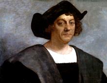
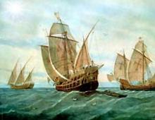
Antilles before the advent of Europeans, the Indian tribes of the Arawaks and Caribs inhabited. In 1493 H. Columbus first saw the islands of Saint Martin and Sint Eustatius, which he called the island of Saint Anastasia. Curacao and Bonaire were discovered in 1499 by the Spanish navigator Alonso de Ojeda. In the 1630s and 40s Curacao, Aruba, Bonaire, as well as Saba, Sint Eustatius (another name - Statia) and part of the island of Saint Martin were captured by the Netherlands, but subsequently they became the subject of constant claims from France and Great Britain. Only under the Paris Treaty of 1815 were they finally assigned to the Netherlands. Rapid flowering in the 17-18 centuries. reached Sint Eustatius, which received the status of a free port from the crown and played an important role in trade relations between the Old and New Worlds. During the period of prosperity, approx. 20 thousand people (now - 1200) and monthly anchored up to 300 ships. It is no coincidence that the island received the second name "Golden Rock of the Caribbean". Curacao in the colonial era was a major center of the slave trade. He lived in exile in Curaçao at the beginning of the 19th century. Liberator of Latin America Simon Bolivar. After the abolition of slavery in 1863, the economies of Curaçao and Bonaire found themselves in a deep crisis, a way out of which was found at the beginning of the 20th century. after the discovery of oil in Venezuela. In 1936, the local male population received the right to vote from the crown and began to actively demand greater independence from the Netherlands. In 1954, the Netherlands Antilles achieved internal autonomy. In 1986, Aruba withdrew from the Netherlands Antilles and became an independent part of the kingdom as its autonomous part. Until recently, the Netherlands followed a policy of gradually preparing the Antilles for independence, but in recent years this practice has been slowed down due to the fragility of the political institutions of the islands in the face of the increased drug threat.
State structure and political system of the Lesser Antilles
According to the statute of December 29, 1954, the Netherlands Antilles are an autonomous part of the Kingdom of the Netherlands and have self-government in internal affairs. Defense and foreign policy remain under the jurisdiction of the crown. The Queen of the Netherlands is represented on the islands by a governor appointed for 6 years (since July 1, 2002 - Fritz Gudgendrag). All laws passed by parliament and government must be approved by the governor. Willemstad is the administrative center and The largest city Netherlands Antilles, other cities - the administrative centers of the islands: Kralendijk (Bonaire Island), Philipsburg (St. Maarten Island), Oranjestad (Sint Eustatius Island), Te Bottom (Saba Island). Legislative power is vested in the unicameral parliament (states) of the Netherlands Antilles. Parliament is elected for 4 years by popular vote by citizens from the age of 18 and consists of 22 members: 14 from Curacao, 3 from Bonaire, 3 from Saint Martin and 1 each from Saba and Sint Eustatius. Speaker - Errol Kova. Executive power is exercised by the Council of Ministers headed by the Prime Minister. The prime minister, usually the leader of the party with the most votes in an election (last election 18 January 2002), is elected by parliament. Prime Minister - Etienne Is (since July 2004). Along with the government of the Netherlands Antilles, each island has an Island Council and a lieutenant governor. The head of state is Queen Beatrix of the Netherlands. Recently, the Netherlands Antilles are experiencing a serious political crisis due to significant disagreements on the formation of the next coalition government and the desire of Saint-Martin to secede from the federation. The most famous Dutch Antillean was the hero of the War of Independence under the leadership of Bolivar in the 1st quarter. 19th century Curaçao native Manuel Piar is the first foreigner to be promoted to general in Venezuela. The fragmentation of the party system of the Netherlands Antilles is mainly due to the orientation of the parties to the island where they are based. Therefore, the government of the Netherlands Antilles is formed on a coalition basis. Most political parties are on the very large island- Curaçao. The Antillean Transformation Party (leader - M. Paurier), the Democratic Party of Curacao (E. Hernandez), the Workers' Liberation Front (A. Gaudette, R. Lak, Edita Wright), the Crusado People's Labor Party (E. Cova), the National People's Party (Susanna Kamelia-Romer), New Antillean Movement, etc. Parties of other islands: Democratic Party of Bonaire, Patriotic Union of Bonaire, Democratic Party of Sint Eustatius, Patriotic Movement of Saint Martin, Democratic Labor Movement of Saba, etc. Leading business organizations - Trade - Chamber of Industry of Curacao, Association of Industry and Commerce of Curacao, Council of Commerce of Curacao. Trade unions - National Confederation of Trade Unions of Curacao, Federation of Workers of Curacao, Christian Confederation of Trade Unions of Curacao.
Economy of the Lesser Antilles
The economic structures of the Netherlands Antilles are significantly dependent on the global situation, as they are primarily oriented towards the sphere of international services (tourism, offshore Finance center, service sea vessels), which accounts for 84% of GDP. The share of industry (oil refining, light and food industry) in GDP is 15%. Agriculture due to depleted soils and scarcity fresh water underdeveloped (cultivation of sorghum, vegetables, tropical fruits, peanuts, and aloe) and reaches only 1% of GDP. The structure of employment corresponds to the structure of the economy: in the service sector - 86% of the workforce, in industry - 13% and in agriculture - 1%. The economically active population is approximately 89 thousand people. with a high unemployment rate of 15%. Electricity generation 1.1 billion kWh (2001). The GDP of the Netherlands Antilles is 2.4 billion dollars, and in terms of per capita 11.2 thousand dollars (2002). Inflation 3-5% per year. On the Curacao islands, Sint Eustatius and Bonaire have 3 transit oil terminals. There is also a dry dock on Curacao - one of the largest in the Western Hemisphere (capable of serving ships with a displacement of up to 155 thousand tons). An important addition to the service specialization of the Netherlands Antilles is their merchant fleet (including foreign ships registered under a "flag of convenience") - 123 ships with a total tonnage of 1.3 million tons (2002). The service sector makes it possible to largely cover the deficit in the balance of payments due to a large negative trade balance. Export of goods in 2002 was 553 million dollars, imports - 1.43 billion dollars. Exports are dominated by petroleum products processed from imported oil. The main import items, apart from oil, are food and manufactured goods. Leading trading partners: USA, Venezuela, Colombia, Netherlands, Japan. The level and quality of life of the Dutch Antilleans is higher compared to their Latin American neighbors, which is largely due to a well-functioning social and communications infrastructure. The length of roads is 600 km, half of them are paved; railways no. Airports 5, incl. 3 international. There are more than 75 thousand regular telephones and 14 thousand mobile phones, 217 thousand radio receivers, approx. There are 70,000 televisions, 3 television stations, and there is cable television that receives Venezuelan channels and satellite programs.
Science and culture of the Lesser Antilles
The center of science and education is the University of the Netherlands Antilles, located on the island of Curaçao. The reflection of the synthesis of the African and European branches of the culture of the Netherlands Antilles was the Westind carnival, where the musical style of calypso dominates. One of most beautiful cities West Indies is Willemstad, which has retained the unique charm of old Dutch architecture, ancient fortresses and churches. Another museum town is Oranjestad on the island of Sint Eustatius. Every year the Netherlands Antilles visit St. 1 million tourists. The island of Saint Martin is especially popular.
"Paradise islands"- this is exactly what the discoverer of these places called these lands, great navigator Christopher Columbus. Great sea depths adjoin here with elevations, which, literally "surfacing" to the surface from azure water, form large and small islands, with coral reefs, sharp volcanic rocks and beaches with white and black sand. Western "outskirts" Atlantic Ocean- this is also the name of these islands, stretched between North and South America. Dozens of small islands in the Caribbean Sea have a geographical name - the Lesser Antilles. And several large ones are the Greater Antilles, respectively. One can talk endlessly about the beauty of the Caribbean. This is a real riot of colors with an incredible number of shades of green. Tropical rainforests and impenetrable jungles, orchids, magnolias, begonias, ferns, groves of coconut and banana palms, sugarcane plantations, various spices, coffee... And all this is watched by a piercing blue sky with textured cumulus clouds running at the call of a strong sea wind.
Natural conditions of the islands caribbean really great. This is a zone of the tropics with a warm and humid climate, little changeable throughout the year. Due to the strong sea breeze, the heat is not felt. Constant air temperatures (+27) and water (+24), all year round attract many tourists here, mainly from Europe and the United States. (
Paradise Islands, Alexander Zamyshlyaev, Around the World.)The Antilles lie between North and South America and form, as it were, a fragmented continuation of the mainland. From the Gulf of Paria at the mouth of the Orinoco to the Strait of Florida, they stretch for 13 degrees of latitude and border the Gulf of Mexico and the Antilles (Caribbean) Sea in a huge circle. Together, they form an area of 228,662 sq. km with a population of 4,333,942 hours. They are divided into two main groups: the Greater and Lesser Antilles. The first include 4 islands: Cuba, San Domingo, or Haiti, Jamaica and Portorico; of these, the first two and the last (the smallest) form an almost straight line, heading from the western corner of Cuba to the Yucatan Peninsula. The Lesser Antilles, about 50 in number, lie between 10-19° N. latitude and form an arc starting from the island of Trinidad and resting on the eastern corner of Portorico. Seven of them contain strong volcanoes, and on the east side of each of these seven islands is a series of calcareous islets. In general, the A. islands give the impression of a mountain range, broken by the Atlantic, Caribbean and Mexican seas, the isolated peaks of which protrude above the water. The highest of these peaks are the Sierra Mestra (2375 m) and Sierra del Cobre (2119 m) in Cuba and the Blue Mountains (2370 m) in Jamaica.
The small A. islands, depending on whether the northeast trade winds reach them earlier or later, are divided into "Windward Islands" and "Leeward Islands". But there is no unanimity in this nomenclature. The British and French call them southern, as well as east. a branch from Tabogo to Dominica by the Windward Islands (Winward Islands, Iles-du-vent), while the islands lying from Dominica to Portorico are the Leeward Islands (Iles sous le vent). The Spaniards, on the other hand, give the first name (Islas-barlo-vento) to all the Small A. Islands from Portorico to Tabogo, while they, and after them some geographers, gave the second name (Islas-soto-vento) to those islands that are scattered along the northern coast South America to the west from Trinidad to Oruba (near the Gulf of Maracaiba). The sea wind softens the hot climate of these islands. The sky here is amazingly clear, the soil unusually rich. In April and May, at noon for half an hour or a whole hour, the spring rains fall, accompanied by the wind. August and October are the main periods of rains, and the thermometer reaches 45 ° C. The sea here is amazingly clear; ebb and flow is barely noticeable. Almost all of these islands suffer from earthquakes and hurricanes. The heat and damp make the climate very unhealthy, and for the same reasons neither wood nor metal is durable here. Coffee, sugar cane and tobacco grow in incredible numbers and are the main objects of agriculture and trade. For the first time the name of these islands "Antiles" is found in 1493 by Peter Martyr d'Angiere, but the origin of this word is unknown. Some believe that this name comes from the island "Antilia", which the tradition of the end of the Middle Ages placed on the Eastern Ocean, while others are of the opinion that the Antilles mean coastal islands, that is, those that lie in front of the mainland of America. Small A. Islands are sometimes also called the Caribbean Islands. Together with the Bahamas, which lie to the north of A. between San Domingo and Florida, the Large and Small A. islands are known under the common name of the West Indies. (
Under which the Advisory Council functions and is headed by the minister.
Of the islands included in the federation, the first was discovered by X. Columbus in 1493 Saint-Martin (later in 1648 it was divided between the Netherlands and France). A few years later, in 1499, the Spanish navigator Alonso Ojeda discovered the southern islands inhabited by the Arawak and Carib Indians. However, at that time no precious metals were found on these islands. Only much later, in the 19th century, a small gold deposit was found in Aruba. In addition, the islands turned out to be quite arid. Therefore, no one claimed them for a long time. In the XVII-XVIII centuries. they were alternately owned by , and . These islands played a significant role for pirates off the coast of South America.
In 1816, the islands finally became the possession of the Netherlands. The Dutch turned Curaçao into an important shopping center and the largest center of the slave trade.
At the beginning of the XX century. with the discovery of oil in Venezuela, Curacao and became the targets of the largest oil monopolies. In 1916, the Anglo-Dutch company Royal Dutch-Shell began building a large oil refinery on the island of Curaçao. Then, in 1925, the "of" company built a powerful oil refinery on the island of Aruba. The processing of Venezuelan oil became the basis for the economic development of the Netherlands Antilles. This had far-reaching socio-economic consequences for the colony. A relatively large industrial proletariat appeared on the islands of Curaçao and Aruba. Together with the migration of labor to oil refineries, it had a detrimental effect on the development Agriculture countries.
During the Second World War, the United States established military bases in Curaçao. The rise of the national liberation movement in the colony made it necessary to grant it internal autonomy in 1954. In 1975, under the pressure of the people, negotiations began between the Antilles and the Netherlands governments on granting independence to the Antilles.
The pre-colonial appearance of the islands has been greatly altered by man, and at the present time the cultural one sharply predominates on them.
The southern islands - Curaçao, Aruba and Bonaire - are composed mainly of metamorphic and crystalline rocks overlain by limestone and volcanic deposits. Structurally, they are the peaks of the water-covered northern Andes of Venezuela. hilly islands.
Explored mineral resources are limited to deposits of phosphorites and raw materials for the production of building materials.
The islands are partially surrounded by coral reefs. There are several convenient bays, and, on the banks of which the city of Willemstad is located, is considered one of the best in the West Indies.
The climate is tropical, arid, monthly temperatures 26-28°. The average annual precipitation is about 500 mm, of which 4/5 falls between October and February. To obtain water on the islands, desalination plants operate, annually giving 12 million. m of fresh water. In some places, rainwater is collected in cisterns. Lots of windmills used to pump water.
Vegetation southern islands consists mainly of dry shrubs and cacti. In some places, dry ones have been preserved.
In racial and ethnic terms, the most diverse population of Curaçao. In recent decades, in the rapid growth of the oil refining industry in the southern islands, many blacks from the West Islands, from Suriname, as well as the Dutch and the inhabitants of the island, immigrated there. On the northern islands Saba, Saint-Martin (the Dutch part) until the 60s of the current century, the population prevailed, but this ratio changed in Curaçao and Aruba with a higher birth rate of the Negro population.
On average, 1.5 billion kWh of electricity is generated per year. All of it is produced at thermal power plants running on petroleum products. In terms of electricity production per capita, the country occupies a leading position in the Latin American region.
The main foreign trade traffic is carried out through Willemstad and Oranjestad, which are among the largest ports in the West Indies. The country has seven airfields, three of which are international.
The basis of foreign trade is oil products and oil, 2/3 of which comes from Venezuela, and the rest - from the countries of the Middle East and Africa. In imports it is 87%; in export - 95%. Petroleum products are exported to the USA, Canada and Common Market countries. A considerable income is brought by dry land - the largest in America, capable of receiving a displacement of 120 thousand tons, as well as ship repair shops serving over 1 thousand ships a year.
The consequence of the dominance of foreign monopolies is a massive rise in prices, covering about 50% of the labor force. All this causes an intensification of the strike struggle in the country.
Development national culture hampered by the colonial status of the country, its multilingualism and significant cultural expansion of the United States. Schooling in the country is not compulsory. First grade primary schools In the southern islands, teaching is conducted in Dutch, followed by a partial transition to Papiamento. In the northern islands, schools are taught in English.
| : · · · · · · · · · · · · · · · · · · · · · · · · · · · · · · · · · |
Antilles - a group of land areas of different sizes between North and South America, once taken by Spanish sailors for the mythological Antillia. They are divided into Large and Small, and together they cover an area of about 229,000 square kilometers. Many of them are uninhabited. The territory of the islands is divided between several states.
Greater Antilles
This group includes four land areas - Cuba, Haiti, Jamaica and Puerto Rico. The first of these is part of the Republic of Cuba, along with the island of Youth and other smaller islands. The second is divided between Dominican Republic and the Republic of Haiti. It is in a unique situation - it is the only island in the world with two capitals.
Jamaica, now part of the Greater Antilles, was once a pirate "capital". And in Puerto Rico, you can see the “glowing” Mosquito Bay and the still powerful defensive fort of El Moro.
Cuba
The island lies 90 kilometers off the coast of the United States of America, resembling a giant crocodile in shape. Not only exotic nature is interesting here, but also a no less rare social structure. Not surprising. Cuba is a socialist republic, where paintings reminiscent of the times of the collapse of the USSR are available to almost anyone. What makes Cuba different, beneficial or not, from the rest of the land that make up the Greater Antilles.

These pictures, as is well known to people from the countries of the former Soviet Union, are fraught with great opportunities and some unpleasant shortcomings. The former include natural food, central pricing, thanks to which a bottle of rum costs the same in the capital and in a remote province, but the latter include a shortage of things and products, an increase in infrastructure difficulties as you move away from the capital, and other "minor troubles" .
Most of the island is flat, about one third is occupied by mountains, while in Cuba there are about 300 beaches of varying purity and attractiveness. The most famous of them is Varadero, but almost everywhere you can find a free land covered with pleasant sand and clear waters of the ocean washing the island.
The waterfalls of Agabama and Salto del Carbuni, as well as natural caves, reservoirs and lakes, are another attractive reason to come to the island for recreation besides the beaches. For nature lovers here real paradise- available in Cuba big number parks and nature reserves, the most popular of which are Topes de Collantes (in which the waterfalls of Caburni and Vega Grande are located), Guanacabibes, "Zapata Swamp".
In Cuba, you can see a unique bee hummingbird, relic reptile manjuari fish, rare and about 400 species of birds. Since 2013, the El Mango biological station has been open to tourists, which allows you to observe migratory waterfowl in their natural habitat. And this is a worthwhile sight, considering where the Greater Antilles are located.
Haiti
The second largest landmass in the Greater Antilles, divided in two between the Republic of Haiti and the Dominican Republic. Here is the most high point throughout the West Indies - Mount Peak Duarte.

More than 20 million people inhabit this island alone, while the Greater Antilles as a whole give shelter to 37,862,400 inhabitants. Despite the fact that there are large territories that are practically not affected by civilization.
There are several nature reserves and national parks in Haiti, as well as the famous "Blue Pool" - three cobalt-blue lakes connected by a cascade of waterfalls. Also noteworthy is Ethan Sumatra (the largest of the salt lakes), national park"La Visit" with located on its territory mountain range De la Selle, Macaya and Fort de Pin parks.
The capital of Haiti, the city of Port-au-Prince, is interesting for its Fort Saint-Jacques and the National Palace with the Champ de Mars surrounding it, cathedrals, as well as the Marche-de-Fer area, where weapons and iron of the 17th-19th centuries and other interesting curiosities are sold.
BUT the best place for bird watching is located on the Trois-Canment lake, or Haut-Galle.
Jamaica
This island is the third largest after Cuba and Haiti. Like the other two, is independent island nation. Once the territory of the Indians, Jamaica, after the arrival of the British and the construction of the city of Port Royal, turned into the capital of the "pirate brotherhood", inheriting this title from the island of Tortuga. Once serving as the capital of the English colony and the only port on the island, Port Royal did not live up to our time and is now abandoned and partially flooded.
For tourists, Jamaica, unlike Cuba, is not a place where you can forget about safety. Here, tourists are not treated as a value. The Antilles as a whole are a haven of contrasts: in the literal sense, paradise nature is adjacent to the danger from people. According to many tourists who have visited Jamaica, four things are definitely worth doing here:
- ride ostriches in Keshu Park;
- visit the Montego Bay nature reserve;
- watch the sunset from the Blue Peak;
- try Blue Mountains coffee.
Puerto Rico
As was the case with many territories of Latin and North America, Puerto Rico was once inhabited by Indians - before Columbus landed on it at the end of the 15th century. The Spaniards built the largest outpost of the Conquista on the island, and the situation changed only in 1897, when autonomy was granted to this land. Shortly thereafter, the United States occupied Puerto Rico.
However, the Antilles, in the form they are now, were formed thanks to the Spaniards. For American tourists, this place is quite popular - which is not surprising, because they do not need any special documents for entry, and flights from the USA to Puerto Rico are considered local. Yellow sand and clear water on the beaches make it attractive to foreign guests, especially since Baccardi rum, famous even in Russia far from Puerto Rico, is produced here.
In addition to the beaches, the capital of the island, the city of San Juan, or rather, its old part, is worth attention. The architecture reminds of the times of the Spaniards-Americans - the colonial style, expressed in small multi-colored, two- and three-story houses.
However, the beaches and the city are not all that the island can interest tourists. The Greater Antilles and Puerto Rico have a not unique, but constant phenomenon - luminous reservoirs. The famous Mosquito Bay (its water glows due to the special microorganisms living in it), along with the bioluminescent ponds of Parghera and Laguna Grande. And, of course, El Moro is a powerful six-level fort, built once by the Spaniards, which withstood more than one attack and at the same time has remained safe and sound.
Lesser Antilles
This is the second part of the huge circle that borders the Gulf of Mexico and the Caribbean Sea. Lesser Antilles - more than 40 inhabited, plus many uninhabited landmasses, together forming a long arc. Seven of them have large volcanoes.

The political affiliation of the islands is very wide - Great Britain, France, Venezuela, Barbados, the Netherlands, the USA, Saint Lucia, etc. have their own possessions here. From the point of view of geography, the Lesser Antilles are divided into leeward and windward.
Netherlands Antilles
This part of the Dutch possession consists of 6 islands: Aruba, Curaçao and Bonaire are located in the south of the archipelago, off the coast of Venezuela, and St. Maarten, Sint Eustatius and Saba are in the north. Strictly speaking, Aruba, Curaçao and St. Maarten are self-governing states within the Kingdom of the Netherlands, while Bonaire, St. Eustatius and Saba have received the status of special communities. The Netherlands Antilles is a mostly calm beach holiday, trekking, diving and yachting.
Aruba, Curacao and Bonaire
The Antilles are rich in surprises - along with very traditional types of recreation, such as beach tourism, sailing, snorkeling, yachting, ecotourism, in Aruba you can also find such unusual entertainment as visiting the caves of Guadirica, the "Tunnel of Love", Ayo Rock. The latter is a unique area of rocks and canyons, where ancient petroglyphs and stones laid out in concentric circles have been preserved. Scientists cannot yet explain who left them, nor how this place was used.
However, the main interest for tourists in Aruba is the beaches. Moreover, there are a lot of beaches on the island, and they are very different - from soft white sand from the divi-divi trees on Eagle Beach, to the comfortable and safe Baby Beach. Each of the exits to the water is suitable for one or another type of entertainment, there are enough hotels of all ranks, and therefore Aruba is a place in every respect pleasant and enjoyable.
Curacao is also great for tourism - the beaches there are covered with white sand, as is the bottom when descending into the sea, too. According to tourists who have been there, there are many cafes and restaurants on the island. At the same time, you can find something to do in addition to the beaches - there is a winery that produces the famous liquor. The Hato Caves are also worth a visit.

The island of Bonaire, like its neighbors, has excellent beautiful beaches, This a good place for diving, windsurfing and yachting. Here, as in Curacao, there is a museum.

St. Maarten, Sint Eustatius, Saba
St. Maarten is the smallest inhabited island on the planet, divided between two states. At the same time, landing at its airport, named after Princess Julianne, is considered one of the most difficult in the world, due to the location of the runway, as a result of which large aircraft fly literally over the heads of tourists on the beaches.

The takeoff and landing of aircraft eventually turned into a kind of attraction - in places where the Antilles are located, it occupies not the last place.
Saba also bears the unofficial title of "pristine queen of the Caribbean", "the most unspoiled island." And well deserved. Compared to other places, there is almost no tourism industry here. And few places suitable for swimming. But here is a great place for divers - an inactive volcano that has turned into an island. The Lesser Antilles "Lands" boast the only marine park of its kind on the planet, located in the waters around Saba.
Unlike Saba, Sint Eustatius has enough beaches covered with white volcanic sand. On the land side, they are surrounded by evergreen shrubs, turning into tropical forests. Forests attract tourists here - the island is quite suitable for exciting trekking, besides, there are a lot of hotels, cafes and restaurants here.

Sint Eustatius is a special island for divers. The Lesser Antilles are predominantly of coral or volcanic origin, which already gives hope for an interesting and intense dive. And here, moreover, under the coral reefs (to the west of Sint Eustatius) more than two hundred sunken ships are hidden.
And they make up, as it were, a fragmented continuation of the mainland. From the Gulf of Paria at the mouth of the Orinoco to the Strait of Florida, they stretch for 13 and border the Gulf and in a huge circle. For the first time the name of these islands "Antiles" is found in 1493 by Peter Martyr d'Angiere, but the origin of this word is unknown. Some believe that this name comes from the island "Antilia", which the tradition of the end of the Middle Ages placed on the Eastern Ocean, while others are of the opinion that the Antilles mean coastal islands, that is, those that lie in front of the mainland of America. The Lesser Antilles are sometimes also called the Caribbean Islands. Together with those that lie to the North of the Antilles between San Domingo and Florida, the Greater and Lesser Antilles are known under the common name West.
Square Greater Antilles: Taken together, the Antilles form an area of 228,662 square kilometers. They are divided into two main groups: the Greater and Lesser Antilles. The first include 4 islands: San Domingo, or, Jamaica and Portorico; of these, the first two and the last (the smallest) form an almost straight line, heading towards the Yucatan by the western corner of Cuba. The Lesser Antilles, about 50 in number, lie between 10-19 ° north latitude and form an arc starting from the island and resting on the eastern corner of Portorico. On seven of them are strong, and on the eastern side of each of these seven islands there is a number of calcareous islets.
Greater Antilles: In general, the Antilles give the impression of a mountain range, torn apart by the Caribbean and Mexican seas, the isolated peaks of which protrude above the water. The highest of these peaks are the Sierra Mestra (2,375 meters) and the Sierra del Cobre (2,119 meters) on and the Blue Mountains (2,370 meters) on. The Lesser Antilles, depending on whether the northeast trade winds reach them earlier or later, are divided into "Windward Islands" and "Leeward".
Greater Antilles: Marine softens the hot climate of these islands. The sky here is amazingly clear, unusually fat. In April and May, at noon for half an hour or a whole hour, the spring rains fall, accompanied by the wind. August and October are the main periods of rains, and the thermometer reaches 45 ° C. The sea here is amazingly clear; and the tide is barely noticeable. Almost all of these islands suffer from and. The heat and damp make the climate very unhealthy, and for the same reasons neither wood nor metal is durable here.
Nature Greater Antilles: Coffee, sugar cane and tobacco grow in incredible numbers and form the main articles and trade.