Underwater structures of yonaguni. Secrets of the oceans: the most mysterious underwater anomalies Strange underwater structures
Underwater pyramids at the bottom of Fuxian Lake (China)
Another underwater pyramid was discovered by a group of scuba divers in 2001 at the bottom of the Chinese lake Fuxian, located in the southwest of China in Yunnan province at an altitude of 1750 m above sea level. At the bottom of the lake, at a depth of 30 m (according to other sources, 40 m), there were the ruins of a huge five-stage pyramid 19 m high with a base length of 90 m.
The mysterious structure was built from massive stone slabs weighing several tons, which made up giant stone steps. The two upper steps of the pyramid, made of sandstone, were destroyed. And the rest of the ledges, built of limestone - a harder rock, are well preserved. No entrances or openings were found in the pyramid itself. Similar pyramids are known in Central and South America, in Mexico and Peru. Scuba divers reported the find to the archaeological center of Kunming University in Yunnan province.
Specialists from this center, led by archaeologist Li Kunshen, using sonars, have established: at the bottom of the lake there are more than thirty different objects, residential buildings, roads, columns. The head of the archaeological center suggested that these objects are the creation of some ancient civilization. The total area of the studied buildings was 2.5 square meters. km. The previously discovered pyramid was located in the very center of the underwater complex.
For several months, scientists have been studying underwater ruins at the bottom of Lake Fuxian. However, they managed to find only one artifact. A small earthenware vessel from the Eastern Han Dynasty, which ruled 25-220 AD. However, the age of the pyramid and other underwater objects is likely to be much older.
In addition to the central pyramid at the bottom of Fuxian Lake, there are at least 9 smaller pyramids and more than 30 other medium and small structures.
In 2010, research on Lake Fuxian (in the Russian press it is called Fushian Hu, perhaps this is another lake?) was continued by a joint Chinese- Russian expedition. From the Chinese side, the expedition was organized by the archaeological group of Kunming University, the diving center Dive Disport and the underwater archaeologist Bao Ling, from the Russian side-
divers Leonid Gavrilov and Evgeny Spiridonov.
The following is information about these studies based on an article on the site http://www.ufo-com.net (original source), which is not always consistent with the data published above.
Chinese archaeologists did not have the opportunity to reach such a great depth (in one place of the article it is said that the pyramids are at a depth of 50 m, in another-
at a depth of 200 m), and also to raise evidence of human activity from there, so they invited Russian divers.
Leonid Gavrilov spoke about some details of the expedition.
- The first observations of the city were made by the archaeologist Li Kunshen (in 2001?), teacher of Dr. Bao Ling. Then, through a diving center, they asked for divers capable of diving to depths of more than 50 m. There are no specialists in Kunming with such qualifications and experience. We conducted dives, taught our Chinese colleagues minimal knowledge in this area, photographed the upper part of the pyramid, found new places for diving and exploration, examined the island in the middle of the lake, gave an expert opinion on further underwater research, conducted a mini ethnographic study of the area around the lake, took samples from the lake and pyramids for further research by geologists in Moscow.
With the help of sonars and a side-scan locator, kindly provided by Chinese specialists, we obtained three-dimensional echograms of this and other pyramids. The shape of the pyramids is close to the Mayan culture, the size of the blocks is from 3 to 5 m, rather, to the pyramids of the Egyptian Giza plateau-
these data are confirmed by our Chinese colleagues,-
said Leonid Gavrilov.
- What we found in the freshwater lake are pyramids over 40 m high-
it's really amazing. It's a new wonder of the world-
our common world heritage, preserved thanks to water,-
and absorbed by water.
The area of the surveyed ruins at the bottom of the lake exceeds the size of the capital of the era of the Eastern Han Dynasty. The city is not mentioned in any of the famous Chinese archives and ancient manuscripts. missing chinese city Yalunvan was supposed to be made of wood and clay, but the structures found are classic megalithic structures, surpassing the Egyptian pyramids in terms of complexity of execution and drawings.
They have been preserved almost in their original form, and have not been touched by time or man. The upper part of one of the three examined pyramids is located at a depth of about 54 m, the lower-
at 97 m. The photographs of the processed stone blocks show drawings similar to the human ear.
As we expected, Fushian Hu Lake-
tectonic origin. Approximate, very approximate age of once ground structures-
from 5,000 to 12,000 BC The lake has been explored to one percent of its area. It is up to 7 km wide, the length of the lake is more than 30 km, the depth reaches 180 m.
Underwater pyramids at the bottom of Lake Kinneret (Israel)
In 2003, Israeli scientists discovered with the help of an echo sounder a massive round stone structure at a depth of 9 m in Lake Kinneret or the Sea of Galilee (Israel). It has the shape of a cone with a base diameter of more than 70 m.
In 2012, the results of the first studies of this strange design by scientists were published. They were described in an article published in the International Journal of Marine Archeology by archaeologist Dani Nadel from the University of Haifa.
The discovered underwater structure is an asymmetric, fish-infested cone of basalt blocks, located at depths of 1.5 to 13 m, about 500 m from southwestern shores of the lake. The base of the dome is blocked by precipitation. According to D. Nadel, this stone structure was made by people from basalts located near the lake. Kinneret. He estimates the weight of the entire structure at 60,000 tons.
Itzhak Paz, an archaeologist from the Israel Antiquities Society, who also participated in the research, suggested based on the history of sedimentation in Lake. Kinneret that this underwater structure is between 2,000 and 12,000 years old. The purpose of this design is still a mystery. It could be a burial place, a cult object, and even a structure in which fish were bred. However, Paz has no doubt that this stone cone was built on the ground.
Mysterious underwater structures in other places of the oceans and seas
Strange underwater structures of a round and pyramidal shape or resembling ruins, in some cases discovered during underwater seismic surveys, in others - clearly visible on photographs from space, are also located at the southern tip of the island. Bimini, off the coast of Florida, North Carolina, Belize, Malta, France, in the Baltic Sea, in a lake in southern Laos, and in many other places. In most cases, scientists do not yet know exactly what they are. According to some researchers, these round structures were once burial mounds, according to others, rounded and pyramidal structures belong to the pyramids, others see the ruins of some sunken cities at the bottom of the oceans and seas.
The underwater anomaly of the Baltic Sea, which was studied by Swedish scientists in 2012, stands apart. It is a stone block about 60 m wide, covered with lines and supported by a stone pillow 8 m high. This megalith resembles in shape and structure stone megaliths Asuki in Japan and the stone carvings of Fuerte de Samaipata in Bolivia.
Conclusion. Underwater megalithic structures - part of the underwater-underground-terrestrial megalithic complex covering the whole world
The above data confirm the wide distribution on the bottom of the oceans, seas and lakes megalithic structures, which have much in common with the underground-terrestrial megalithic complex that I have identified (especially Yonaguni, Ponape, Titicaca, etc.), as well as its proposed assignment to a single underwater-underground-terrestrial megalithic complex that makes up a significant part of the continents and the bottom of the oceans, seas and lakes.
See my selections of photographs and comments on them in the topics "Underground-ground-underwater megalithic complex of Kekova (Turkey)", "Underground-underground megalithic complex Achziv - Rosh Khanikra (Israel)" and "Remains of buildings and objects made of iron and ceramics in Antalya of the period Paleolithic". These photographs show the continuation of the ground part of the Complex at the bottom of the Mediterranean Sea
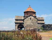
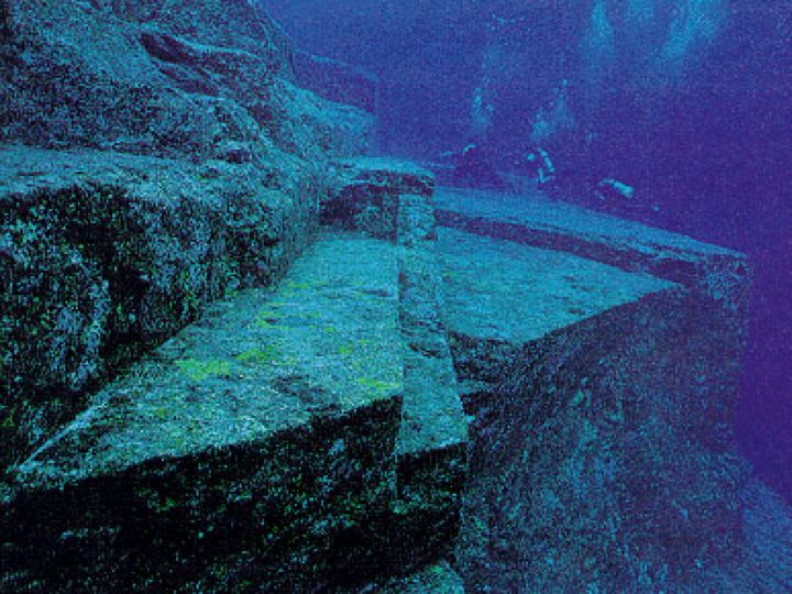
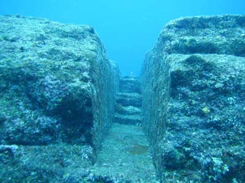
A massive stone structure in Japan, off the Yonaguni Islands, south of Okinawa.
This step pyramid was created using advanced technology and belongs to the prehistoric era. It didn't attract much attention until scientists and adventurers dived many times, took pictures and freed this amazing structure from the ground. to measure and map the structures of the Yonaguni Monument, as it came to be called. it huge complex The building, which includes castles, monuments and a stadium, is connected by a complex system of roads and waterways, says Kimura. In all likelihood, it went under water during the devastating earthquake and tsunami. Japan is located in an area of great tectonic instability - the Pacific Ring of Fire. Large earthquakes often occur in the area. The world's largest recorded tsunami struck the island of Yonaguni Zhima in 1771. The waves reached a height of over 40 meters. Perhaps a similar catastrophe befell the ancient civilization that created these structures. Kimura presented his study and computer model of underwater ruins at a scientific conference in Japan in 2007. According to him, there are 10 underwater structures near the Yonaguni Islands, and five more such structures are located at the main Okinawa Islands. Massive ruins cover an area of more than 45,000 sq.m. Kimura believes the ruins are at least 5,000 years old. His calculations are based on the age of stalactites found in underwater caves, which Kimura believes sank with the city. Stalactites and stalagmites only form above water in an extremely slow process. Underwater caves with stalactites found around Okinawa indicate that most of the area was once on land. News" in 2007. Over the years, he created a detailed picture of these ancient ruins, and found many similarities between underground structures and those found in archaeological excavations on land. For example, a semi-circular cutout on a rocky platform corresponds to the entrance to the castle, which is located on land. Nakagusuku Castle in Okinawa has a perfect semi-circular entrance, typical of Ryukyu castles in the 13th century. Gifu. But many scientists argue that all these structures are natural formations that appeared as a result of the impact of waves on rocks over the millennia. Boston University geologist Robert M. Schoch, known for referring the date of the Sphinx to an earlier era, changed his mind about the structure of Yonaguni. Initially, after making several dives at the site, he considered the platforms and stepped structures to be completely natural formations. formed about 20 million years ago. Kimura acknowledges that the underlying rock structure is natural, but claims that it has been altered by humans. For example, it is difficult to explain the two pairs of steps leading from the "main terrace" to the "upper terrace" by natural erosion. Kimura also points out that stones and loose blocks were not found at the base of many buildings or in rock-cut passages, as one would expect, if they were formed by natural erosion. After diving more, Schoch stated, "We should also consider the possibility that the Yonaguni Monument is a largely natural formation used, improved, and modified by humans in ancient times," he wrote in article in 1999. Ancient and more modern civilizations used natural rock formations for various purposes. The most famous example is the Sphinx in Egypt, which was carved from natural rock; other examples are the temples of Petra in Jordan and Mahabalipuram in India. As scientists and scuba divers continued their exploration, many finds were made. One has the appearance of a seated statue similar to the Sphinx. "One specimen, which I described as an underwater sphinx, resembles a Chinese or ancient Okinawan king," Kimura told National Geographic magazine. This mysterious carved sculpture is now called the "rock of the goddess." It was found at a depth of 15 meters. Up close, you can see a headdress and long arms, like those of the Egyptian Sphinx. A large round stone resembling a human face was also found. Like the Moai sculptures on Easter Island off the coast of Chile, this gigantic head rests on the ground, perhaps peering into the distant horizon. Some believe that this figure forms a virtual axis or focal point. According to another version, it could be the legendary giant Atlas, who glorified this sunken city. Some scuba divers and researchers noticed carvings on the rock around the monument resembling letters, some claim to have seen animals carved on the rock; others believe that these lines are of natural origin. Stone tablets found nearby, one of them is known as the "Rosetta Stone from Okinawa", are covered with symbols similar to Egyptian hieroglyphs. The contents of the tablets have not been deciphered, however, this may be the story of a sunken city, since the image of a pyramid is constantly repeated there. Stone tools have been discovered in the vicinity. An underwater pyramid and other relics discovered near the islands of Yonaguni Zhima may be evidence of the existence of an advanced civilization in the last ice age. period. Most archaeologists believe that human civilization arose about 5,000 years ago, however, few scientists believe that "advanced" civilizations may have existed as early as 10,000 years ago, and were wiped off the face of the earth as a result of some kind of catastrophe. Link to
September 1, 2013, 21:54Thanks to the ancient ancient manuscripts, we know that people have always believed that new lands rise from the depths of the oceans, and old ones can sink under the water, destroying entire civilizations.
The most famous underwater lands are the island of Atlantis, which Plato wrote about 2.5 thousand years ago. Maritime archeology has only become academic in the last 50 years, with the advent of technology for research. Now more than 500 places with the remains of man-made structures have been discovered under water, many of which are from 3 to 10 thousand years old ... Recently, with the development of technologies and special techniques, including sonar, it was possible to come across very curious underwater anomalies.
Some strange objects, such as the Bimini Road, for example, cause a lot of controversy. Some of the anomalous places are not so close to the surface, but are hidden at great depths.
1. Mysterious structure in the Sea of Galilee (Israel)
In 2003, scientists were surprised when they discovered a massive stone circular structure underwater at a depth of 9 meters in the Sea of Galilee (Israel). This structure is composed of basaltic rocks, is cone-shaped and twice the diameter of Stonehenge in the UK.

Only recently were the results of studies of this strange design published. Archaeologists say that it has very similar features to the ancient communal burial grounds that are found all over the world. Researchers believe that it can date back to more than 4,000 years ago.

According to them, it was definitely artificial and was probably built on land and then sank when the level of the Sea of Galilee rose.
2. Mysterious Underwater Structures on Google Maps
Strange circular structures can be seen in images from space off the coast of Florida, North Carolina and Belize. They were noticed by archaeologists and researchers strange places on Google Earth images. Although similar anomalies have been seen in many other parts of the world, researchers do not yet know exactly what they are. Some believe that once these round structures could be burial mounds.

3. A strange structure in a Canadian lake
Divers discovered traces of the past of the ancient inhabitants of western Canada while participating in a unique underwater project in 2005. They found a very curious stone structure at a depth of about 12 meters in Lake McDonald, Ontario, Canada.

This structure consists of an elongated piece of stone weighing about 450 kilograms with an almost flat surface, which rests on 7 stones the size of baseballs, which, in turn, stand on a slab weighing about a ton.

At first it was assumed that this is a natural structure, until geologists and archaeologists studied pictures of the structure in more detail. It has been proven that this object was man-made. Such objects are well known to scientists, they are called seids and are objects of worship of the northern peoples. There are especially many of them in the Russian North, which will be discussed below.
Secrets of Seydozero (Russia)
The sacred Saami Seydozero, located in the very center Kola Peninsula, at the very end of the 20th century, became the focus of attention of many researchers. It was here that the remains of the oldest civilization in the history of mankind were discovered.
Ancient artifacts discovered back in 1997 in the Lovozero tundra mountain range surrounding Seydozero were identified as the remains of ancient fortifications, landscape-type sanctuaries, cult and navigation (perhaps even astronomical) objects.
Dense silt fills the bottom pit of the lake to a depth of 20 meters. It is almost impossible to see or find anything under such a "veil". However, scientists decided to "comb" the lake with the help of an echo sounder and georadar. The instruments showed that a fairly even bottom in shallow water suddenly broke off and went to a depth of 20 or even 30 meters. In the lagoon, over which Mount Ninchurt hangs, first an echo sounder, and then a radar, recorded two deep wells. According to the readings of the instruments, one of the underwater manholes led somewhere under the Ninchurt mountain, merging, perhaps, with some of its internal voids.
Impressive stone slabs rise to the surface right in the middle of the lake. Where did they come from? The georadar recorded voids under the slabs, as if they were hiding some unknown underwater tunnel.
Near Seydozero, directly under the ancient glade, there is a vast underground void. Or maybe a cave? It started at a depth of 9 meters and went beyond the 30-meter mark - this was the limit for the instrument readings. The total length of the georadar profile of Seydozero is two kilometers, and it leads from the relict glade, where the Sami camp was once located, to the foot of Mount Ninchurt. So far, from the standpoint of geology, no one can explain how a real underground passage leading towards the mountain was formed in the local rocks (where there should not be caves). The vast void under the clearing may be a karst ravine, but under the bottom of the lake we clearly saw not a ravine, but a real dungeon with a stone floor and vault.
But while the caves and underground passages are inaccessible for visual examination, since they are below the lake level and are filled with sand, pebbles, peat and water.
Pyramids of Rock Lake (USA)
According to experts, they were built no earlier than the last ice age - at least 12,000 years ago. Naturally, the question arises as to which civilization created them. The lake is located 40 km east of Madison, Wisconsin, USA. The length of the reservoir reaches 8 km, and the width is 4 km. In 1836, Nathaniel Heyer discovered a small stone pyramid in the lake. She, like the South American pyramids, had a flat top. He named her Atzalan.
Record-breaking deep-sea diver Max Jean Knowle also became interested in the mystery of Lake Rock. In 1937, he crossed the lake in different places in a small boat and dragged a metal blank along the bottom on a strong cable. With the help of this homemade "device", Knowle located underwater objects and made many dives to examine the stones that his "device" stumbled upon. Knowle, according to him, found one pyramid approximately in the middle of the lake. He made an entry in his diary:
“The building has the shape of a truncated pyramid. At the top is a small square platform with a side of 1.4 m. The side of the square base is 5.43 m, and the height of the pyramid is 8.83 m. The structure, obviously, consists of smooth stones connected by a building compound. The stones are covered with a thick greenish coating, which is easily scraped off, and then a smooth gray surface of the stones is revealed.
In subsequent years, scuba divers dived to the bottom of the lake several times, confirming this find. The scuba diving magazine Skin Diver wrote in the January 1970 issue of the Rock Lake mystery: "These pyramids are absolutely incredible, impossible - they are too old and are in a place where no one could build them. From the point of view of logic, they cannot exist, but history rarely obeys the correct logic."
What was found in the waters of Rock Lake - stone pyramids with cut tops - until that time it was found only in Mexico and Guatemala. The next question is the time of the construction of the lake pyramids. The logical conclusion suggests itself: before the lake appeared on this place. But, as follows from the conclusions of geologists, Rock Lake was formed 10 thousand years ago! What kind of civilization existed here at that time? After all, earlier there was an opinion that ten thousand years ago there were only small tribes with a very primitive way of life in this territory. It is impossible even to admit that they were able to build such structures. So, in those distant times, not these (or not only these) tribes lived in these places, but some other, more developed people? No information about him, however, has been preserved.
"Stonehenge" of Lake Michigan
Although Stonehenge in the UK is one of the world's most famous ancient stone monuments He's far from the only one. Similar stone structures have been found around the world.

In 2007, while exploring the bottom of Lake Michigan using sonar, a team of underwater archaeologists discovered a series of rocks arranged in a circle at a depth of 12 meters. An engraved drawing was found on one of the stones.

The image is similar in shape to a mastodon, an animal that died out about 10 thousand years ago. The version of the ancient Stonehenge is quite plausible, because scientists have already found similar structures in the area.
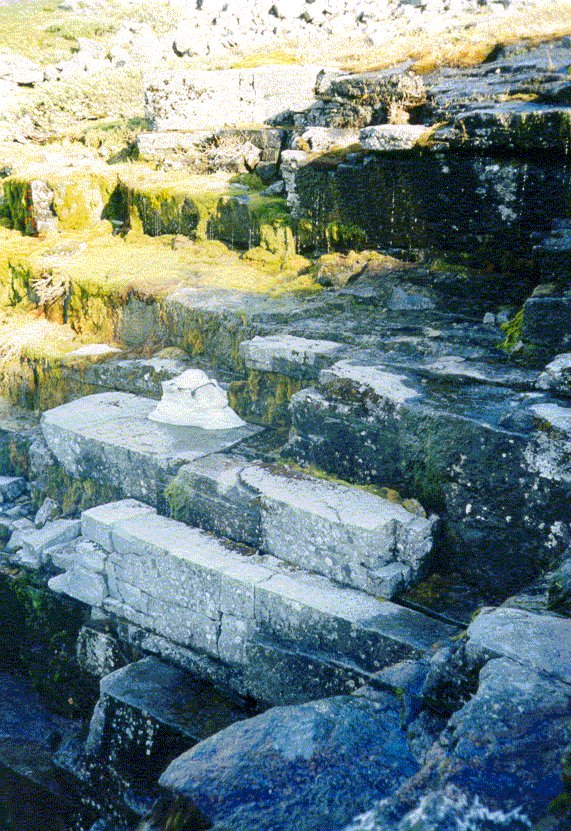
Crimean megaliths at the bottom of the Black Sea
According to the theory of the Black Sea Flood, put forward in 1996 by geologists William Ryan and Walter Pitman from Columbia University in the USA, on the site of the Black Sea in the sixth millennium BC. e. there was a freshwater lake, on the shore of which the settlements of the ancient inhabitants of the Northern Black Sea region could theoretically be located. Around 5600 B.C. e. (according to some sources, in 3800 BC) the Dardane Flood disaster occurred, due to which the level of this lake rose by 100–150 meters and flooded vast territories. Scientists suggest that it was this catastrophe that became the source of the legends about the Flood.

However, evidence that on the shore freshwater lake there were once antediluvian settlements, there was not. And only in 2007, Sevastopol divers for the first time announced that they had stumbled upon some artificial caves with windows and steps. It was then that there was talk that a sunken cave city was found off the coast of Crimea. Moreover, at a depth of 10 to 14 meters, which fundamentally contradicted the statements of historians. Moreover, the earliest Crimean cave cities scientists date back to the Middle Ages, but since then no large-scale disasters have occurred.
An underwater expedition, two miles from the coast in the Shtormovoy area, really discovered some artificial structures that outwardly very much resemble megalithic temples - massive columns and walls supporting multi-ton stone roofs. But the history of the construction of the Taurus megaliths really goes back thousands of years. Few people know that in the Crimea on land and now there are dolmens similar to those in the Caucasus, the so-called "Crimean boxes". And it is quite possible that a certain part of them ended up on the seabed after the sea disaster.
However, scientists are still skeptical about the discovery. Although it is no longer ruled out that people could once live in this area.
Underwater city off the island of Cuba
A series of underwater structures was discovered off the coast of the island of Cuba in 2001. These structures have attracted a lot of interest from archaeologists, historians and Atlantis hunters from all over the world. Sonar images taken by a team of seafloor researchers showed symmetrical and geometrically regular structures that span an area of about 2 square kilometers at depths ranging from 600 to 750 meters.
Skeptics believe that these structures are too deep to be the work of man. According to estimates, for the structures to sink to such a depth, at least 50 thousand years must pass.

If conclusive evidence is found that the structures are man-made, they could add much to our knowledge of ancient civilizations whose cities sank into the depths of the ocean.
Japanese Yonaguni Monument
Since the "Yonaguni Monument" was discovered in 1987 off the coast of Japan, it has been the subject of controversy between archaeologists and researchers of underwater mysteries. Many argue that the area's natural landscapes have been altered by human hand, as in the case of the Sacsayhuaman complex in Peru.
If these assumptions are true, then man changed the area around the 10th millennium BC. Skeptics, on the other hand, believe that the entire structure is natural, and the drawings and stone carvings are just natural scratches. However, looking at the photo, it is hard to believe that these structures are just natural formations.

Bimini Structures
During the 2006 and 2007 expeditions, side-scan sonar and seismo-acoustic profiling mapped the landscapes of the interior to the west of the Bimini Islands.
A series of rectangular structures called "Bimini Road" was discovered at a depth of about 30 meters. All these structures were lined up in the same direction in parallel lines. The researchers reported that the structures closely resemble those found off the coast of Cuba.

Later mysterious structures were examined in more detail. Judging by the depth at which these structures are located, they must be at least 10 thousand years old.
Discoveries in the Gulf of Cambay (India)
In May 2001, the discovery of the ruins of an ancient city in the Gulf of Cambay was announced. This discovery was made using sonar. The ancient city was located on a flat area, living quarters lined up in even rows, drainage systems, baths, barns and a fortress were discovered. The city belonged to a previously unknown ancient civilization of Hindustan.

Detailed studies of these places followed, artifacts were discovered. Among them are wood dating back to about the 7th millennium BC, stones that looked like tools, fossilized bones, fragments of dishes and even a tooth.

This city may have existed since 9500 BC. If it really existed then, it is thousands of years older than the most ancient city of India - Varanasi.
Nan Madol
On the Pacific island of Ponape, one of the islands of Micronesia, the ruins of an ancient city are located in the water. locals called Nan Madol, which means "On the lips of the High Leader."
The ruins of the city of Nan Madol are visible today in the form of small artificial islands, the number of which is about 82. At the base of these islands, the remains of rectangular buildings are visible, the walls of which are partially preserved in fairly good condition. Some of the walls reach a height of 9 meters from the base. In general, chaos reigns in the ruins - giant "sticks" are scattered throughout the complex, which leaves the impression of destruction as a result of a powerful natural disaster.
In some places you can see how the walls go into the depths sea water. In recent years, the universities of Ohio State, Oregon State (USA) and the Pacific Institute (Honolulu) have undertaken scuba diving expeditions into the ocean depths near Nan Madol. They discovered various elements of gigantic structures, such as huge stone columns, a system of tunnels, streets paved with huge rectangular blocks. Swimming among the sharks along the underwater streets of the sunken cyclopean city, they found giant columns, 20 to 30 meters high, whose bases rest at a depth of about 60 meters. Drawings were also found on underwater plates - geometric shapes such as circles and rectangles.

Archaeologists, who examined these pillars a few years ago, got to their core and confirmed that they were also made of basalt and installed here by someone in unknown times and for an unknown purpose. If you give free rein to your imagination, then you can compare them with the remains of some huge gates. Or with two steles on the sides of the entrance to ancient city Nan Madol at a time when it was still entirely above sea level.
Structures at the bottom of Lake Titicaca (Bolivia)
On its banks, many ancient structures have been preserved, in particular, the impressive ruins of the mysterious "city of the gods" Tiahuanaco. Its established age is at least 15,000 years.

Now the city is located at an altitude of almost 4000 meters, that is, at an altitude with very sparse vegetation and unsuitable for human habitation. However, the remains of a large port, sea shells, images of flying fish and the skeletons of fossil marine animals indicate that this city was once located on the seashore.
Geologists attribute the rise of the Andes to a period of 60-70 million years ago, that is, to a time when a person should not have existed on Earth yet. When researchers recently descended to the bottom of the lake, they found the remains of buildings there, walls made of huge boulders. These walls, running along a paved pavement, parallel to each other, stretched for more than a kilometer.

Of course, some of these ancient cities were washed away by floods, but others ended up at the bottom of the seas or oceans under the influence of tectonic shifts in the earth's crust. And, of course, initially these structures were built on land. But the Earth may have been geographically different from what we see it now.
So is our humanity today really the pinnacle of evolution, or is it just one of the same numerous peaks, in an endless series of cycles that originate in the distant, distant past?
Updated on 01/09/13 22:51:
Rama Bridge
These images from space were taken by the NASA shuttle in 2000. Now they hang in Buddhist temples - in India and Sri Lanka. The monks revere them as sacred relics - because they confirm the veracity of the legends. According to some - a million years ago, others, 20 thousand - between India and Sri Lanka, an army led by the legendary King Rama built a bridge 50 km long.
According to old English, Portuguese and Arabic sea charts the bridge was pedestrian until the end of the 15th century AD, but was destroyed by an earthquake.
Heinrich Schliemann found Troy using only the text of an ancient poem, and he confirmed that behind the epic is not only fiction, but sometimes historical truth. It is generally accepted that today there is not a single artifact proving that the events described in the Ramayana actually happened ... But the bridge itself, 50 km long, is not a needle at all, it is a gigantic artifact in itself, and it is described in the Ramayana exactly where we are rediscovering it now ...
Rock Lake is located 40 km east of Madison, Wisconsin. On cloudy days, the water in it looks cloudy and the bottom cannot be seen. But one day in April 1936, in clear weather, a certain Dr. Morgan, flying over a pond in his sports plane, accidentally looked down - and saw the outlines of three large objects under the water surface. Morgan descended - and his eyes appeared distinct silhouettes of pyramids with truncated tops!
After this incident was reported in the newspapers, researchers became interested in Rock Lake. Soon a team of scuba divers descended to the bottom of the lake. The young biologist W. Kennedy was able to examine the stone wall of a certain structure under water. Going around it, the scientist was convinced that the building really has a pyramidal shape. He took with him a trophy - a broken piece of masonry. However, when Kennedy tried to return to the pyramid with his comrades, they failed to find it. A few years later, another group of enthusiasts arrived at Rock Lake, taking their equipment with them. Underwater archaeologists examined the entire body of water in squares - and found the first pyramid!
The construction was of the correct form and had a rectangular base measuring 9x10 m. It, of course, was a creation of human hands. Later, researchers found another building, slightly different parameters from the first. In 1985, off the coast of the Japanese island of Yonaguni, diving instructor Kihachiro Aratake accidentally stumbled upon a strange object consisting of stone platforms covered with geometric patterns and stepped terraces. The entire structure was surrounded by a deep trench. By appearance it resembled the pyramids of the ancient Sumerians. A group of archaeologists who arrived at the site discovered a sculpture depicting a human head in an Indian feather headdress near the building.
It turned out that the underwater structure of unknown origin is similar to the high-altitude sanctuary of Machu Picchu, built by the Incas in South America. In both cases, L-shaped blocks were used for construction, providing a "seamless" connection. In addition, both here and there, the craftsmen used a unique processing technology that protects buildings from the effects of natural elements. But how did an Inca temple off the coast of Japan come about? After all, we are talking about a culture that originated on another continent! Or do we still not know much about the history of civilizations?
Not so long ago, another pyramid was found at the bottom of the Chinese lake Fuxian (southwestern province of Yunnan). Its height is 19 m, the length of the side of the base is 90 m. The structure is built of stone slabs and has a stepped structure. At the bottom of the lake there are about a dozen more similar objects and about 30 structures of other types ... The total area architectural complex is about 2.5 sq. km. But, if the previous finds date back to quite old periods of time, then who will explain the mystery of the so-called Bermuda pyramids? For the first time this phenomenon was announced in the summer of 1991 at a press conference in Freeport by the famous oceanographer Dr. Verlag Meyer. He claimed that when examining the bottom in the area of the famous "Bermuda Triangle" at a depth of 600 m, the equipment found two giant pyramids. In size, they even exceeded the pyramid of Cheops in Egypt.
According to the scientist, both structures were built using an unknown technology, from a material similar to thick glass. But the most interesting thing is that they were built only about half a century ago!
In 1985, in Okinawa Prefecture in Japan, about south coast islands of Yonaguni, local diver Kihashiro Aratake, taking care of the development of tourism in these places, made introductory dives into the crystal clear waters of the ocean and suddenly stumbled upon underwater pyramid a little more than 24 m high. With a flat top, it towered 91 cm above the water. Impressed by the find, Kihashiro called it "a place of ruins." Word of the find quickly spread among enthusiastic divers and, despite strong currents and a large population of hammerhead sharks, undersea world around the island began to actively explore.
The bulk of those who personally examined the underwater structures have no doubt that they were made human hands. However, as always, there were skeptical archaeologists who did not bother with personal observations, but limited themselves to stories and amateur photographs. They considered the finds to be an unusual natural formation. Professional geologists do not share this confidence.
A well-known Japanese geologist, Professor Masaaki Kimura gathered a group of students and organized a professional survey of underwater structures. Since 1992, continuous research has been carried out. In 2000, measurements were made using a laser, multibeam echo sounders, airplanes, and sonars. As a result, scientists came to the conclusion about the artificial nature of underwater monuments. The publication of the facts and their detailed justification convinced many skeptics.
American geologist Robert Schoch flew to Japan in 1997 to personally inspect the find. After a series of dives, he expressed his opinion that in essence the Yonaguni monument is a natural structure, but processed and modified by people. This construction practice is generally typical for residents of the East Asian region, when some changes are made to the natural environment, for example, Zen gardens, ritual Japanese
landscapes, Chinese feng shui. The practice of terraforming is designed to create a harmonious relationship between people and the environment.
Dr. Schoch admitted the possibility of human influence on the monument, but did not believe in it. Whereas Kimura believed that the results of many years of research indicate the artificial origin of the underwater complex.
One of the most convincing evidence can be considered ancient hand tools found on the island and under water. In the Ryukyu Islands, which includes Yonaguni, they are called kusabi. The peculiarity of these objects is that they are made of igneous rock, but it is not found on Yonaguni. Accordingly, the material must be imported from somewhere in order to make tools from it for processing soft sandstone.
At the same time, traces of processing were found on its surfaces, possibly left by kusabi.
Sharks abound on the coast of Yonaguni, a small Japanese island.
No one knows why they gather in such numbers right there, near this island. What draws these predators here remains a mystery.
On top of some stones there are drilled holes spaced 200 mm apart, as if they were marked on a ruler. Mollusks could not do this, because the best of sea diggers - the sea urchin - is not suitable for them in shape.
Master mason Kotara Maja explained why these holes were needed. When he saw them, he immediately recognized the method used to date for breaking off stone blocks. Holes are first drilled into them from the edge, then large sticks are inserted into them and strongly pushed back and forth, pouring water until the rock cracks in a straight line and separates into a building block of the required size. Another well-known stonemason Koutaro Shinza from Okinawa confirmed the findings of a colleague. In this regard, there is a version that the underwater monuments of Yonaguni were once a quarry.
Another evidence of the artificial origin of the structures are small rectangles on the stones, found where there are no strong eroding currents. These 7.5 cm long openings could not have formed naturally. The presence of recesses also seems to indicate a quarry, but there could also be unfinished construction, interrupted by rising ocean levels.
The lower parts of the block structures look finished. For the most part, they do not have these holes, but there are architectural elements, for example, the "ring road" - something like an artificial path, laid around the base of the structure and connected to its top by a drainage channel. The surface of the trail is smooth, as if lined with stone blocks.
Professor Kimura investigated a structure resembling a staircase. On some sides, it has obvious traces of human processing. One part of it can be recognized as a real staircase. At the bottom of the monument there are peculiar massive stone heaps. The connections formed by the blocks are even on each of the vertical "pillars".
Underwater structures have many details that are very problematic to explain from the standpoint of geology. For example, a large in-depth image of an hourglass carved into the surface of a stone. Next to it is a long straight channel ending in a short flight of seven steps. Below is a narrow tunnel, characterized by high-quality masonry blocks and even connections. If you swim further along the tunnel, you can find yourself in front of a kind of "double towers". These are vertical granite slabs, similar to 2 books, 580 cm. They are separated by an opening 7.5 cm wide. Most likely, the sun could be observed through this gap in certain time. Probably, these "double towers" are initially astronomically oriented, since they are tilted to each other at the same angle.
The most convincing evidence of the artificial origin of the monuments can be considered 17 hieroglyphs carved on them, and one full-fledged inscription. Four characters are duplicated several times. Obviously, they are carved by a human hand.
It is not possible to read them. The same symbols are found on the monumental structures of Nan Madol.
Not far from the key underwater structure of Yonaguni, there is a huge “stage”, which is a perfect square of monolithic rock, rising above the bottom by at least 550 cm.
The sides of the square are the same and equal to 21.3 m, so they give the impression of an artificial structure.
But that's not all. Associated with this platform amazing story. In 2000, diver Thomas Holden filmed an underwater story for cable television. With his video camera, he snatched out an image of a huge human face on the "stage". Even earlier, professional underwater photographer Cecile Hagrend noticed this feature when carved into the stone, the ghostly outlines of a helmet or wings, possibly a winged helmet above a human head. Japanese researchers decided to measure the portrait. During the work, despite thousands of years of erosion, the image could distinguish the features that the sculptor sought to give to the face: the configuration and proportionality of the eyes are noticeable. According to Professor Kimura, "the pupil of the right eye is elongated in the meridional direction." The geologist gave the name moai to the find, using the native word of the inhabitants of Easter Island, with which they designated their famous statues. He didn't just do it. The eyes of 2 found persons (2 were also found on the "stage") were directed towards this island. In the Okinawan dialect, any ancient sacred structure is called a moai. Therefore, some connection of the monuments near Yonaguni is very likely, not only with Nan Madol, but also with Easter Island.
Despite the fact that the underwater structures of Yonaguni are similar to each other, elements of various types can coexist in a small area of \u200b\u200bthe same monument: a sharp edge with rounded holes, a stepped descent with a perfectly straight narrow trench. It is rather difficult to imagine that natural factors could take part in this, since if water erosion took place, then the same forms would be on the entire surface of the monument.
Although Dr. Shoh doubted the artificial origin of the underwater structures, he could not avoid comparison with similar structures found in Okinawa, especially in the vicinity of Naha, the capital of the prefecture. Another similar structure is called Naku Gusuku Castle. It was built for military purposes about 500 years ago and has since undergone numerous reconstructions. However, its foundation dates back to the 1st-2nd centuries. Once there was a ceremonial center and an aristocratic cemetery. It can be said with great certainty that this place has been surrounded by special reverence since ancient times. Carved into the rocks nearby are what look like gigantic steps and wide platforms of the underwater monument of Yonaguni. The tombs have not received much attention from archaeologists. They couldn't
determine neither the age nor the origin of the culture that created them. Nevertheless, it can be argued that the structures underwater and on land testify to a continuously evolving architectural style that is unique to this part of the world.
Using the radiocarbon method, Professor Kimura tried to find out the age of underwater structures. Radiocarbon dating of coral “twigs” from the monument showed values within 4000 BC. e. However, this is the time of the beginning of coral growth, but not the time of erection and submersion of ancient structures under water. Based on the known rate of coral growth, the scientist suggested that the flooding occurred about 12,000 years ago. Then the sea level was 30.5-35.5 m lower than now. That is, until the end of the Pleistocene era, the base of the monument was on land, and it is not known how long it stood before the catastrophe.
There is a definite connection between the various centers of ancient cultures throughout the Pacific region. Apart from Nan Madol, Easter Island and some other archaeological finds in China, Japan, this includes the ritual center on the opposite side Pacific Ocean- along the coast South America. To the south of the current capital of Peru, the city of Lima, are the gloomy ruins of Pachacamac, the religious capital of ancient Peru. Built long before the rise of the Incas, it features wide tiers and huge steps leading up to spacious plazas. There is an impression that the Yonaguni monument was transferred from under the water to the land.
Near the coastal town of Trujillo there is an ancient structure that resembles the same underwater monument.
The Temple of the Sun, made in the pre-Inca era from unbaked clay bricks, has a latitudinal solar orientation similar to the location of the sunken monument. And they are almost the same size.
After the discovery of an underwater complex near the island of Yonaguni, the researchers decided to expand the search area in the hope of stumbling upon new monuments of an ancient civilization and were not disappointed. Approximately 9.5 km southwest of Aka Island, also part of the Ryukyu Islands, diver Mitsutoshi Taniguchi at a depth of about 23.5 m discovered stone circles and rectangular structures similar to the foundations of buildings, as well as a ring of standing stones with a diameter of 18 ,2 m and more than 1.8 m high. A similar ring was found further to the northeast. True, it turned out to be smaller in diameter. The largest concentric structure of small rounded stones has a diameter of 146.6 m. Thus, throughout the Pacific region there are structures suggestive of one ancient civilization that created them.