Russian travelers of the 19th century briefly. Russian travelers of the 19th century
In the 19th century, Russian researchers made a number of outstanding geographical discoveries. In 1803 I. Kruzenshtern on the "Nadezhda" and "Neva" made the 1st Russian round-the-world expedition, exploring the northern part Pacific Ocean, Sakhalin, Alaska, Aleutian Islands. Y. Lisyanyakiy on the Neva discovered one of the Hawaiian Islands. In 1819-21 F. Bellingshausen and M. Lazarev on the sloops "Vostok" and "Mirny" made the 2nd Arctic expedition. During its 16/1/1820, the ships approached Antarctica, which Bellingshausen called the "ice continent". Having rested in Australia, the expedition moved to the tropical Pacific Ocean and discovered islands in the Tuamotu archipelago. They were named after Kutuzov, Lazarev, Raevsky, Barclay de Tolly, Yermolov and others. After resting in Sydney, the ships returned to Antarctica and discovered about. Peter I and the land of Alexander I. In July 1821, the ships returned to Kronstadt, bringing great amount materials and collections. The development of Russian America is associated with the name of A. Baranov. A merchant from Kargopol had been trading in Alaska since 1790. He made detailed maps of Alaska and nearby islands. In 1799 Baranov became the ruler of the colonies in America. In 1804 He founded Novoarkhangelsk. Baranov tried to annex Hawaii to Russia, but failed. Despite his illness, he remained in office until his death. Territory Far East remained a white spot on the Russian map. In 1848, Nicholas 1 sent an expedition of G. Nevelsky to the Far East. He proved that Sakhalin Island and explored the lower reaches of the Amur. E. Putyatin during the round-the-world expedition of 1822-25. discovered the Rimsky-Korsakov Islands and concluded an agreement with Japan. Round-the-world expeditions were made by V. Golovin-1807-11,F. Litke-1826-29 and made 50 cards. I. Voznesensky in 1839-40 described Alaska, the Aleutian and Kuril Islands. In 1809 A. Kolodkin began to explore the Caspian. In 1848, E. Hoffman and M. Kovalsky explored the North. Ural. In 1845, the Russian Geographical Society was established.
Russian pioneers and travelers of the 19th century made a number of outstanding discoveries, which became the property of not only Russian, but also foreign, world science. In addition, they made a significant contribution to the development of domestic knowledge and did a lot to promote the training of new personnel for the development of marine research.
Prerequisites
Russian pioneers and travelers of the 19th century made their discoveries largely because this century saw the need to look for new trade routes and opportunities to support Russia's ties with other countries. At the end of the 18th - beginning of the 19th century, our country finally strengthened its status in the international arena as a world power. Naturally, this new position expanded its geopolitical space, which required new exploration of the seas, islands and ocean coasts for the construction of ports, ships and the development of trade with foreign countries.
The Russian discoverers and travelers of the 19th century took place as talented navigators just at the very time when our country achieved access to two seas: the Baltic and the Black. And it is no coincidence. This opened up new prospects for maritime research and gave impetus to the construction and development of fleets, maritime affairs in general. Therefore, it is not surprising that already in the first decades of the century under consideration, Russian discoverers and travelers of the 19th century carried out a number of outstanding studies that significantly enriched Russian geographical science.
World expedition plan
Such a project became possible largely due to the successful military operations of our country at the end of the 18th century. At this time, Russia got the opportunity to build its own fleet on the Black Sea, which, of course, should have stimulated maritime affairs. Russian navigators at that time seriously thought about laying convenient trade routes. This was further facilitated by the fact that our country owned on the territory North America Alaska. It was also necessary to maintain constant contacts with her and develop economic cooperation.
I.F. Kruzenshtern at the end of the 18th century presented a plan for a round-the-world expedition. However, then he was rejected. But just a few years later, after the accession of Alexander I, the Russian government showed interest in the presented plan. He got approved.

Training
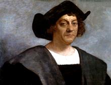
I.F. Kruzenshtern came from a noble family. He studied at the Kronstadt Naval Corps and, being his student, took part in the war against Sweden, having proven himself well then. After that, he was sent for an internship in England, where he received an excellent education. Upon his return to Russia, he presented a plan for a round-the-world expedition. Having received approval, he carefully prepared for it, purchased the best instruments and equipped the ships.
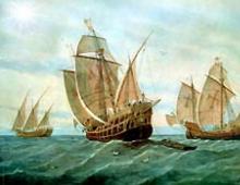
His closest assistant in this matter was his comrade Yuri Fedorovich Lisyansky. He became friends with him back in the cadet corps. The friend also proved himself to be a talented naval officer during the Russian-Swedish war of 1788-1790. Soon, two ships were equipped under the names "Neva" and "Nadezhda". The latter was led by Count Nikolai Rezanov, who became famous thanks to the famous rock opera. The expedition set sail in 1803. Its goal was to explore and explore the possibility of opening new trade routes from Russia to China and the coast of North American territory.

Swimming
Russian navigators rounded Cape Horn and, having entered the Pacific Ocean, separated. Yuri Fedorovich Lisyansky led his ship to the North American shores, where he recaptured the Russian trading city of Novo-Arkhangelsk captured by the Indians. During this trip, he also spent the first time in the history of navigation sailing ship around South Africa.
The ship "Nadezhda" under the leadership of Kruzenshtern went to the Sea of Japan. The merit of this explorer is that he carefully explored the shores of Sakhalin Island and made significant changes to the map. The main thing was to explore what the management was interested in for a long time Pacific Fleet. Kruzenshtern entered the Amur Estuary, after which, having explored the shores of Kamchatka, he returned to his homeland.

Kruzenshtern's contribution to science
Travelers of Russia have significantly advanced Russian geographical science, bringing it to the world level of development. attracted the attention of the general public. After the end of the trip, both wrote books that outlined the results of their research. Krusenstern published Journey Around the World, but the atlas he published with hydrographic applications is of particular importance. He filled in many blank spots on the map, carried out valuable studies of the seas and oceans. So, he studied the pressure and temperature of the water, sea currents, ebbs and flows.
Social activity
His further career was closely connected with the naval corps, where he was first assigned as an inspector. Subsequently, he began to teach there, and then generally headed it. On his initiative, the Higher Officer Classes were created. Later they were transformed into the Naval Academy. Kruzenshtern introduced new disciplines into the educational process. This has significantly increased the quality level of teaching maritime affairs.
In addition, he helped organize other expeditions, in particular, contributed to the plans of another prominent explorer, O. Kotzebue. Kruzenshtern took part in the creation of the famous Russian Geographical Society, which was destined to take one of the leading places not only in Russian, but also in world science. Of particular importance for the development of geography was the Atlas of the South Sea he published.
Preparing a new expedition
Krusenstern, a few years after his trip, insisted on a thorough study of the southern latitudes. He proposed to equip two expeditions to the Northern and south poles two ships each. Prior to this, the navigator came very close to Antarctica, but the ice prevented him from passing further. Then he suggested that the sixth continent either does not exist, or it is impossible to get to it.
In 1819, the Russian leadership decided to equip a new squadron for navigation. Faddey Faddeevich Bellingshausen, after a series of delays, was appointed its leader. It was decided to build two ships: Mirny and Vostok. The first was designed according to the plan of Russian scientists. It was durable and water resistant. However, the second, built in the UK, was less stable, so it had to be rebuilt, rebuilt and repaired more than once. The preparation and construction was led by Mikhail Lazarev, who complained about such a discrepancy between the two ships.

Journey south
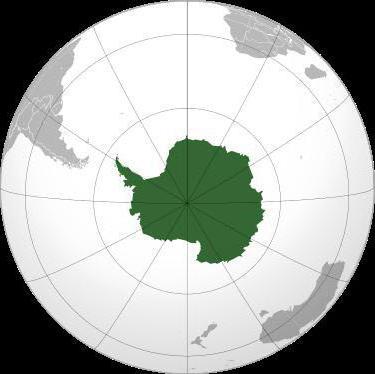
A new expedition set off in 1819. She reached Brazil and, rounding the mainland, came to the Sandwich Islands. In January 1820, a Russian expedition discovered the sixth continent - Antarctica. During the maneuvers around it, many islands were discovered and described. Among the most significant discoveries are the island of Peter I, the coast of Alexander I. Having made the necessary description of the coast, as well as sketches of the animals seen on the new mainland, Faddey Faddeevich Bellingshausen sailed back.
During the expedition, in addition to the discovery of Antarctica, other discoveries were made. For example, participants discovered that Sandwich Land is an entire archipelago. In addition, the island was described South Georgia. Of particular importance are the descriptions of the new continent. From his ship, Mikhail Lazarev had the opportunity to observe the earth better, so his conclusions are of particular value for science.

The value of the discoveries
The expedition of 1819-1821 was of great importance for domestic and world geographical science. The discovery of a new, sixth continent, turned the idea of the geography of the Earth upside down. Both travelers published the results of their research in two volumes with an atlas and necessary instructions. During the trip, about thirty islands were described, magnificent sketches of the views of Antarctica and its fauna were made. In addition, the expedition members have collected a unique ethnographic collection, which is kept at Kazan University.
Further activities
Bellingshausen subsequently continued his naval career. He participated in the Russian-Turkish war of 1828-1829, commanded the Baltic Fleet, and then was appointed governor of Kronstadt. An indicator of the recognition of his merits is the fact that a number of geographical objects. First of all, the sea in the Pacific Ocean should be mentioned.
Lazarev also distinguished himself after his famous trip to Antarctica. He was appointed commander of an expedition to protect the coast of Russian America from smugglers, with which he successfully coped. Subsequently commanded Black Sea Fleet participated in which won several awards. So, the great discoverers from Russia also make your outstanding contribution to the development of geography.
Moscow Automobile and Highway State Technical University
By discipline: Culturology
Russian travelers of the 19th century
Made by Evstifeeva Anna
student of group 1bmo2
Checked Shorkova S.A.
Moscow 2013
Introduction
Chapter 1 half of XIX century
1 I.F. Kruzenshtern and Yu.F. Lisyansky
2 F.F. Bellingshausen and M.P. Lazarev.
3 A.A. Baranov
Chapter 2. Travelers of the second half of the 19th century
1 G.I. Nevelskoy and E.V. Putyatin
2 N.M. Przhevalsky
3 N.N. Miklukho Maclay
Conclusion
Introduction
The 19th century was the time of the largest geographical discoveries made by Russian explorers. Continuing the traditions of their predecessors - explorers and travelers of the 17th-18th centuries, they enriched the ideas of Russians about the world around them, contributed to the development of new territories that became part of the empire. Russia for the first time realized an old dream: its ships entered the oceans.
Chapter 1. Travelers of the first half of the 19th century
.1
I.F. Kruzenshtern and Yu.F. Lisyansky
In 1803, at the direction of Alexander I, an expedition was undertaken on the ships Nadezhda and Neva to explore the northern part of the Pacific Ocean. It was the first Russian round-the-world expedition that lasted 3 years. It was headed by Ivan Fedorovich Kruzenshtern, the largest navigator and geographer of the 19th century.
During the voyage, more than a thousand kilometers of the coast of Sakhalin Island were mapped for the first time. Many interesting observations were left by the participants of the journey not only about the Far East, but also about other areas through which they sailed. The commander of the Neva, Yuri Fedorovich Lisyansky, discovered one of the islands of the Hawaiian archipelago, named after him. A lot of data was collected by the members of the expedition about the Aleutian Islands and Alaska, the islands of the Pacific and Arctic Oceans.
The results of the observations were presented in the report of the Academy of Sciences. They turned out to be so significant that I.F. Kruzenshtern was awarded the title of academician. His materials formed the basis of the book published in the early 1920s. "Atlas of the South Seas". In 1845, Admiral Krusenstern became one of the founding members of the Russian Geographical Society. He brought up a whole galaxy of Russian navigators and explorers.
1.2 F.F. Bellingshausen and M.P. Lazarev.
One of the students and followers of Kruzenshtern was Faddey Faddeevich Bellingshausen. He was a member of the first Russian round-the-world expedition.
In 1819-1821. Bellingshausen was instructed to lead a new round-the-world expedition on the sloops (single-masted ships) Vostok (which he commanded) and Mirny (commander Mikhail Petrovich Lazarev). The expedition plan was made by Kruzenshtern. Its main goal was "the acquisition of the most complete knowledge about our globe" and "the discovery of the possible proximity of the Antarctic Pole."
On January 1820, the expedition approached the shores of Antarctica, unknown at that time, which Bellingshausen called "the ice continent." After stopping in Australia, the Russian ships moved to the tropical part of the Pacific Ocean, where they discovered a group of islands called the Russian Islands.
For 751 days of navigation, Russian sailors covered about 50 thousand km. The most important geographical discoveries were made, valuable collections, observational data on the waters of the World Ocean and ice sheets of a continent new to mankind were brought.
1.3
A.A. Baranov
Alexander Andreevich Baranov can hardly be attributed to the discoverers or travelers in the strict sense of these words. But he was a man who made an invaluable contribution to the development of Russian America by our compatriots. Being a Kargopol merchant, he traded in Eastern Siberia, and from 1790 - in North-West America.
In search of new hunting areas, Baranov studied Kodiak Island and other territories in detail, searched for minerals, founded new Russian settlements and supplied them with everything necessary, and established exchanges with local residents. It was he who managed for the first time to truly secure vast territories on the Pacific coast of North America for Russia.
Baranov's activities were extremely difficult and dangerous. The constant raids of the Indians cost the Russian settlers not only a lot of money, but also their lives. In 1802 alone, more than 200 settlers were killed while trying to create a settlement on the island of Sitka.
Baranov's efforts were so successful that in 1799 he became the ruler of the Russian-American Company, and in 1803 he was appointed ruler of the Russian colonies in America. This high and dangerous post he held almost until his death.
In 1804, Baranov founded the Novoarkhangelsk fortress on the island of Sitka, and then Fort Ross. In 1815 he undertook an expedition to Hawaiian Islands with a view to their accession to Russia. However, she did not bring good luck. Being already an elderly and sick man, Alexander Andreevich asked for his resignation three times. However, they were in no hurry to let such a person leave the service.
geographic Russian round-the-world expedition
Chapter 2. Travelers of the second half of the 19th century
The largest researcher of the Russian Far East in the middle of the XIX century. was Gennady Ivanovich Nevelsky.
In two expeditions (1848-1849 and 1850-1855), he managed, bypassing Sakhalin from the north, to discover a number of new, previously unknown territories and enter the lower reaches of the Amur. Here in 1850 he founded the Nikolaevsky post (Nikolaevsk-on-Amur). Nevelsky's travels were of great importance: for the first time it was proved that Sakhalin was not connected to the mainland at all, but was an island and the Tatar Strait was a strait, not a bay, as it was thought.
Evfimy Vasilyevich Putyatin in 1822-1825 committed trip around the world and left to posterity a description of what he saw. In 1852-1855. during the expedition led by him on the frigate "Pallada" the islands of Rimsky-Korsakov were discovered. Putyatin became the first Russian who managed to visit Japan, which was closed to Europeans, and even signed an agreement there (1855).
The result of the expeditions of Nevelsky and Putyatin, in addition to purely scientific ones, was the consolidation of the Primorsky region in the Far East for Russia.
The most important among these institutions was the Russian Geographical Society, opened in 1845. It has become the center of geographical knowledge in Russia.
2.2 N.M. Przhevalsky
Przhevalsky dreamed about wanderings with early years and worked diligently for them. But the Crimean War broke out - he went as a private in the army. And then years of study at the Academy of the General Staff. However, a military career did not attract him at all. Staying at the Academy was marked for Przhevalsky only by compiling Military Statistical Review of the Amur Territory .
However, this work allowed him to become a member of the Geographical Society. In early 1867, Przhevalsky submitted to the Society a plan for a major and risky expedition to Central Asia. However, the audacity of the young officer seemed excessive, and the matter was limited to his business trip to the Ussuri Territory with permission carry out any scientific research . But Przhevalsky met this decision with enthusiasm. In this first trip, Przhevalsky made up the most Full description Ussuri region and gained valuable expeditionary experience. Now they believed in him: there were no obstacles for traveling to Mongolia and the country of the Tanguts - Northern Tibet, which he dreamed about. During the four years of the expedition (1870-1873) it was possible to make significant amendments to the geographical map. In 1876, he again sets a course for Tibet. Przhevalsky was the first European to reach mysterious lake Lopnor, discovers the previously unknown Altyndag ridge and determines the exact border of the Tibetan Plateau, establishing that it begins 300 km to the north than previously thought. But this time he failed to penetrate deep into this country, almost unknown to Europeans. And yet, three years later, the Russian explorer reached the coveted highlands. The absolute lack of exploration of this area attracted Przhevalsky, who sent here in the early 1880s. your expedition. It was his most fruitful journey, crowned with many discoveries. True, Przhevalsky did not succeed in discovering the source of the Huang He (it was found only quite recently), however, the Russian expedition studied in detail the watershed between the Yellow River - the Yellow River and the largest Blue River in China and Eurasia - the Yangtze. Previously unknown ridges were plotted on the map. Przhevalsky gave them names: Columbus Ridge, Moscow Ridge, Russian Ridge. He called one of the peaks of the latter the Kremlin. Subsequently, in this mountain system a ridge appeared that immortalized the name of Przhevalsky himself. In the course of all his expeditions, Przhevalsky, being a professional geographer, made discoveries that could bring fame to any zoologist or botanist. He described a wild horse (Przewalski's horse), a wild camel and a Tibetan bear, several new species of birds, fish and reptiles, hundreds of species of plants. And he was on his way again. Tibet again beckoned him to itself. This time, Przhevalsky firmly decided to visit Lhasa. But all plans collapsed. He was dying in his tent, barely starting the journey. Before his death, he asked his companions to bury him by all means on the shore of Issyk-Kul, in a marching expedition uniform ... .
November 1888 Nikolai Mikhailovich Przhevalsky died. His last request was granted. 2.3 N.N. Miklukho Maclay
Every culture, every tribe or nation, every human being has the right to self-sufficiency. Interacting, communicating, they should proceed from mutual respect, not seeking to impose their own rules, their way of life by force and not imposing their thoughts. These principles were close and understandable to Nikolai Nikolayevich Miklukho-Maclay, who was brought up in an intelligent Russian family during the heyday of Russian culture, primarily literature, permeated with the ideas of freedom, humanism, goodness and the search for truth. Having studied biology and medicine in Germany, having made several scientific expeditions (he was an assistant to the famous biologist and ecologist E. Haeckel), he returned to Russia and then decided to go to New Guinea. K.M. Baer recommended that he observe people "without prejudice as to the number and distribution of human tribes and races" Until the middle of the XIX century. New Guinea remained aloof from the economic interests of the European industrial powers. Perhaps it was influenced by the fact that no deposits of precious metals were found on it. It is also possible that the reason for this is the rumors about the local cannibal savages. In addition, lush tropical vegetation prevented the development of these territories. A more or less thorough study of New Guinea began in 1871-1872: Italian scientists Luigi Albertis and Odoardo Beccari explored the northwestern part of the island. Miklouho-Maclay had to hurry to catch at least some of the Papuan tribes in their natural state. Therefore, he chose the practically unexplored southeastern coast of New Guinea, landed there in September 1871 and lived among the "savages" for more than a year, communicating with them, winning their respect and trust. The first stay on the banks of Maclay. On September 1871, the Vityaz anchored about 140 meters from the shore. Soon the Papuans appeared; Miklukho-Maclay, refusing to guard, with Ohlson and Boy landed on the shore and visited the village, the entire population of which fled into the jungle. The most daring was a Papuan named Tui (in the pronunciation recorded by D.D. Tumarkin in 1977 - Toya). It is Tui who will become the main intermediary of Miklouho-Maclay with the inhabitants of the coastal villages. Nazimov warned that he would be able to stand for no more than a week, so Miklukho-Maclay, with the help of Tui, found Garagassi cape, where a hut for a scientist was built (size 7 ×14 feet), and in a hut belonging to Tui, they set up a cookery. At the insistence of the commander of the "Vityaz", site 70 ×70 m was mined; information about whether Miklukho-Maclay used mines contradicts each other and is unverifiable. Of the products, Nikolai Nikolayevich had two pounds of rice, Chilean beans, dried meat and a can of edible fat. Nazimov forced Miklukho-Maclay to take the team's daily allowance - that is, a daily supply of food for 300 people, but Nikolai Nikolayevich refused to take the supply free of charge. September 27 "Vityaz" left the bay. The first month in New Guinea was quite tense. Miklouho-Maclay came to the conclusion that his visits disturbed the islanders too much and limited himself only to contacts with the natives who visited him at Cape Garagassi. Since he did not know the language and customs well, at first he limited himself to meteorological and zoobotanical research. Already on October 11, he was overwhelmed by the first attack of fever, and repeated attacks continued during the entire stay of the scientist in the Astrolabe Bay. The servants were constantly ill, especially Boy, who Miklouho-Maclay diagnosed with a "swelling of the lymphatic glands in the groin." The operation did not help, on December 13 the boy died. Miklouho-Maclay at the same time remembered the promise given to Professor Gegenbaur to obtain a preparation of the larynx of a black man with a tongue and all the muscles, which he prepared, despite the danger of the situation. By January 1872, Miklouho-Maclay's authority among the local population had grown, and on January 11 he received an invitation to the village of Bongu for the first time. There was an exchange of gifts, but the wives and children of the New Guineans were still hidden from the scientist. In February 1872, Nikolai Nikolaevich managed to heal Tui from a serious wound (a tree fell on him, the wound on his head festered), after which the scientist was received in the village, Tui introduced him to his wife and children; the opinion of the European as an evil spirit was significantly shaken. The symbolic inclusion of the ethnographer in the local society took place on March 2 at a night ceremony, in which the men of three related villages - Gumbu, Gorendu and Bongu participated. Artistic description Miklouho-Maclay himself left the ceremony in his diary. After that, the scientist could safely make long-distance excursions along the coast and even into the mountains. The language barrier created the greatest difficulty: by the end of his first stay in New Guinea, the scientist spoke about 350 words of the local Bongu language, and at least 15 languages were spoken in the vicinity. The explored territories, the shores of the Astrolabe Bay and part of the coast to the east of it to Cape Huon, Miklouho-Maclay called by his own name - “Miklukho-Maclay Coast”, defining its geographical boundaries as follows: from Cape Croazil in the west to Cape King William in the east, from the seashore in the northeast to the highest mountain range of Mana Boro-Boro in the southwest. Conclusion
World geographical science in those years largely relied on the achievements of Russian researchers. By the end of the XIX century. the era of geographical discoveries ended. And only the icy expanses of the Arctic and Antarctic still kept many of their secrets. The heroic epic of the latest geographical discoveries, in which Russian researchers took an active part, falls at the beginning of the 20th century. Bibliography
1.Danilov A.A. History of Russia, XIX century. Grade 8: textbook. for general education institutions / A.A. Danilov, L.G. Kosulin. - 10th ed. - M.: Enlightenment, 2009. - 287 p., L. ill., maps. 2.Zezina M.R. Koshman L.V. Shulgin V.S. History of Russian culture. - M., 1990
Russian navigators, along with European ones, are the most famous pioneers who discovered new continents, sections of mountain ranges and vast water areas.
They became the discoverers of significant geographical objects, took the first steps in the development of hard-to-reach territories, and traveled around the world. So who are they - the conquerors of the seas, and what exactly did the world learn about thanks to them?
Afanasy Nikitin - the very first Russian traveler
Afanasy Nikitin is rightfully considered the first Russian traveler who managed to visit India and Persia (1468-1474, according to other sources 1466-1472). On the way back he visited Somalia, Turkey, Muscat. On the basis of his travels, Athanasius compiled the notes "Journey Beyond the Three Seas", which became popular and unique historical and literary aids. These notes became the first book in the history of Russia, made not in the format of a story about a pilgrimage, but describing the political, economic and cultural features of the territories.
Afanasy Nikitin
He was able to prove that even as a member of a poor peasant family, one can become famous researcher and traveller. Streets, embankments in several Russian cities, motor ship, passenger train and aircraft
We recommend reading 
Semyon Dezhnev, who founded the Anadyr prison
Cossack chieftain Semyon Dezhnev was an Arctic navigator who became the discoverer of a number of geographical objects. Wherever Semyon Ivanovich served, everywhere he sought to study the new and previously unknown. He was even able to cross the East Siberian Sea on a makeshift koch, going from Indigirka to Alazeya.
In 1643, as part of a detachment of explorers, Semyon Ivanovich discovered Kolyma, where he founded the city of Srednekolymsk with his associates. A year later, Semyon Dezhnev continued his expedition, walked along the Bering Strait (which did not yet have this name) and discovered the easternmost point of the mainland, later named Cape Dezhnev. An island, a peninsula, a bay, a village also bear his name.

Semyon Dezhnev
In 1648, Dezhnev set off again. His ship was wrecked in the waters located in the southern part of the Anadyr River. Having reached on skis, the sailors went up the river and stayed there for the winter. Subsequently, this place appeared on geographical maps and was called the Anadyr prison. As a result of the expedition, the traveler was able to make detailed descriptions, make a map of those places.
Vitus Jonassen Bering, who organized expeditions to Kamchatka
Two Kamchatka expeditions inscribed the names of Vitus Bering and his associate Alexei Chirikov in the history of marine discoveries. During the first trip, the navigators conducted research and were able to supplement the geographical atlas with objects located in Northeast Asia and on the Pacific coast of Kamchatka.
The discovery of the Kamchatka and Ozerny peninsulas, the bays of Kamchatsky, Krest, Karaginsky, the Bay of Conduct, the island of St. Lawrence is also the merit of Bering and Chirikov. At the same time, another strait was found and described, which later became known as the Bering Strait.

Vitus Bering
The second expedition was undertaken by them in order to find a way to North America and explore the Pacific Islands. On this journey, Bering and Chirikov founded the Peter and Paul prison. It got its name from the combined names of their ships ("Saint Peter" and "Saint Paul") and subsequently became the city of Petropavlovsk-Kamchatsky.
On the approach to the shores of America, the ships of like-minded people lost sight of each other, heavy fog affected. "Saint Peter", controlled by Bering, sailed to the west coast of America, but got into a severe storm on the way back - the ship was thrown onto an island. The last minutes of Vitus Bering's life passed on it, and the island subsequently began to bear his name. Chirikov also reached America on his ship, but successfully completed his voyage, finding several islands of the Aleutian ridge on the way back.
Khariton and Dmitry Laptev and their “named” sea
Cousins Khariton and Dmitry Laptev were like-minded and assistants to Vitus Bering. It was he who appointed Dmitry the commander of the Irkutsk ship, and Khariton led his double boat Yakutsk. They took part in the Great Northern Expedition, the purpose of which was to study and accurately describe and map the Russian shores of the ocean, from Yugorsky Shar to Kamchatka.
Each of the brothers made a significant contribution to the development of new territories. Dmitry became the first navigator to survey the coast from the mouth of the Lena to the mouth of the Kolyma. He made detailed maps of these places, based on mathematical calculations and astronomical data.

Khariton and Dmitry Laptev
Khariton Laptev and his associates conducted research on the northernmost section of the coast of Siberia. It was he who determined the size and shape of the huge Taimyr Peninsula - he surveyed its eastern coast, and was able to identify the exact coordinates of the coastal islands. The expedition took place in difficult conditions - a large amount of ice, snowstorms, scurvy, ice captivity - the team of Khariton Laptev had to endure a lot. But they continued the work they had begun. On this expedition, Laptev's assistant Chelyuskin discovered the cape, which was later named after him.
Noting the great contribution of the Laptevs to the development of new territories, members of the Russian Geographical Society decided to name one of them after them. largest seas Arctic. Also, the strait between the mainland and Bolshoy Lyakhovsky Island is named after Dmitry, and the name of Khariton is West Coast the islands of Taimyr.
Kruzenshtern and Lisyansky - the organizers of the first Russian circumnavigation of the world
Ivan Kruzenshtern and Yuri Lisyansky are the first Russian navigators to circumnavigate the world. Their expedition lasted three years (started in 1803 and ended in 1806). They set off with their teams on two ships, which bore the names "Nadezhda" and "Neva". Travelers passed through Atlantic Ocean entered the waters of the Pacific Ocean. On them the sailors sailed to Kuril Islands, Kamchatka and Sakhalin.

Ivan KruzenshternThis journey made it possible to collect important information. Based on the data obtained by navigators, a detailed map Pacific Ocean. Another important result of the first Russian round-the-world expedition was the data obtained on the flora and fauna of the Kuriles and Kamchatka, local residents their customs and cultural traditions.
During their journey, the sailors crossed the equator and, according to maritime traditions, could not leave this event without a well-known ritual - a sailor dressed as Neptune greeted Krusenstern and asked why his ship arrived where it had never been Russian flag. To which he received the answer that they are here solely for the glory and development of national science.
Vasily Golovnin - the first navigator who was rescued from Japanese captivity
Russian navigator Vasily Golovnin led two round-the-world expeditions. In 1806, being in the rank of lieutenant, he received a new appointment and became the commander of the sloop "Diana". Interestingly, this is the only case in the history of the Russian fleet when a lieutenant was entrusted with the management of a ship.
The leadership set the goal of the round-the-world expedition to study the northern part of the Pacific Ocean, with special attention to that part of it that is within the native country. The path of "Diana" was not easy. The sloop passed the island of Tristan da Cunha, passed the Cape of Hope and entered the port, which belonged to the British. Here the ship was detained by the authorities. The British informed Golovnin about the outbreak of war between the two countries. The Russian ship was not declared captured, but the crew was not allowed to leave the bay either. After spending more than a year in this position, in mid-May 1809, the Diana, led by Golovnin, tried to escape, which the sailors successfully succeeded in - the ship arrived in Kamchatka.

Vasily Golovin The next important task Golovnin received in 1811 - he had to draw up descriptions of the Shantar and Kuril Islands, the shores of the Tatar Strait. During his journey, he was accused of not adhering to the principles of sakoku and was captured by the Japanese for more than 2 years. It was possible to rescue the crew from captivity only thanks to the good relations of one of the Russian naval officers and an influential Japanese merchant, who was able to convince his government of the harmless intentions of the Russians. It is worth noting that no one in history has ever returned from Japanese captivity before.
In 1817-1819, Vasily Mikhailovich made another round-the-world trip on the Kamchatka ship specially built for this.
Thaddeus Bellingshausen and Mikhail Lazarev - discoverers of Antarctica
Captain of the second rank Thaddeus Bellingshausen was determined to find the truth about the existence of the sixth continent. In 1819, he went to the open sea, carefully preparing two sloops - Mirny and Vostok. The latter was commanded by his associate Mikhail Lazarev. The first round-the-world Antarctic expedition set itself other tasks. In addition to finding irrefutable facts confirming or refuting the existence of Antarctica, the travelers were going to explore the waters of three oceans - the Pacific, Atlantic and Indian.

Thaddeus Bellingshausen The results of this expedition exceeded all expectations. During the 751 days that it lasted, Bellingshausen and Lazarev were able to make several significant geographical discoveries. Of course, the most important of them is the existence of Antarctica, it is historical event happened on January 28, 1820. Also during the trip, about two dozen islands were found and mapped, sketches were created with views of Antarctica, images of representatives of the Antarctic fauna.

Mikhail Lazarev
Interestingly, attempts to discover Antarctica were made more than once, but none of them were successful. European navigators believed that either it did not exist, or it was located in places that simply could not be reached by sea. But the Russian travelers had enough perseverance and determination, so the names of Bellingshausen and Lazarev are included in the lists the greatest sailors peace.
Yakov Sannikov
Yakov Sannikov (circa 1780, Ust-Yansk, Russian Empire - after 1811) - Russian merchant from Yakutsk, miner of arctic fox, mammoth tusk and explorer of the New Siberian Islands.
Known as the discoverer of the ghost island "Sannikov Land", which he saw from the New Siberian Islands. He discovered and described the islands of Stolbovoy (1800) and Faddeevsky (1805).
In 1808-1810, he participated in the expedition of the exiled Riga Swede M. M. Gedenstrom. In 1810 he crossed the island of New Siberia, in 1811 he bypassed the island of Faddeevsky.
Sannikov expressed an opinion about the existence to the north of the New Siberian Islands, in particular from Kotelny Island, of a vast land called "Sannikov Land".

After 1811, traces of Yakov Sannikov are lost. Neither further occupation nor the year of death are known. In 1935, the pilot Gratsiansky, who flew in downstream of the Lena River, near Kyusyur, discovered a tombstone with the inscription "Yakov Sannikov". The strait is named after him, along which a section of the Northern Sea Route passes today. It was opened in 1773 by the Yakut industrialist Ivan Lyakhov. Initially, the strait was named after the expedition doctor E.V. Tolya V.N. Katina-Yartseva F.A. Mathisen. The current name is given to K.A. Vollosovich on his map, and in 1935 approved by the government of the USSR.
Grigory Shelikhov
Grigory Ivanovich Shelikhov (Shelekhov; 1747, Rylsk - July 20, 1795, Irkutsk) - Russian explorer, navigator, industrialist and merchant from the Shelekhov family, from 1775 engaged in the arrangement of commercial merchant shipping between the Kuril and Aleutian island ridges. In 1783-1786 he led an expedition to Russian America, during which the first Russian settlements in North America were founded. He organized several trading and fishing companies, including those in Kamchatka. Grigory Ivanovich explored new lands for the Russian Empire, was the initiator of the Russian-American Company. Founder of the North East Company.

The bay was named after him. Shelikhov Bay (Kamchatka region, Russia) is located between the Asian coast and the base of the Kamchatka Peninsula. Refers to the water area of the Sea of Okhotsk.
Ferdinand Wrangel
Wrangel showed himself from the best side, and he, tested in a difficult circumnavigation, instructed to lead an expedition to the extreme north-east of Siberia, to the mouths of the Yana and Kolyma, in order to map the coast of the Arctic Ocean up to Bering Strait, and besides this, to test the hypothesis of the existence of an undiscovered land connecting Asia with America.
Wrangel spends three years in ice and tundra with his companions, among whom his main assistant was Fedor Matyushkin, a lyceum comrade A.S. Pushkin.
In between trips to the North, under the leadership of Wrangel and Matyushkin, a topographic survey of the vast coast was made, covering 35 degrees in longitude. On the territory of the recently white spot, 115 astronomical points were identified. For the first time, studies of the impact of climate on the existence and development of sea ice, and the first meteorological station in this region was organized in Nizhnekolymsk. Thanks to the meteorological observations of this station, it was established that in the interfluve of the Yana and Kolyma there is a "pole of cold" of the Northern Hemisphere.
Ferdinand Wrangel described the expedition and its scientific results in detail in a book that was first published in 1839 and was a huge success. The famous Swedish polar explorer Adolf Erik Nordenskiöld called it "one of the masterpieces among the writings on the Arctic".

The expedition in the Chukotka-Kolyma Territory put Wrangel on a par with the largest explorers of the harsh Arctic. Subsequently, becoming one of the founders of the Russian Geographical Society, he thought over the project of an expedition to the North Pole. He proposes to go to the Pole on a ship, which should be wintering off the northern coast of Greenland, to prepare food warehouses along the route of the polar party in the fall, and in March people go exactly in the direction of the meridian on ten sleds with dogs. Interestingly, the plan to reach the pole, drawn up by Robert Peary, who entered the pole 64 years later, repeated the old Wrangel project in the smallest detail. An island in Severny is named after Wrangel. Arctic Ocean, a mountain and a cape in Alaska. Having learned about the sale of Alaska by the Russian government in 1867, Ferdinand Petrovich reacted very negatively to this.
5 / 5 ( 145 votes)
Fanatical people these scientists, researchers. How do you read what you had to go through and experience in distant geographical expeditions, that you wonder - why did they need it? Part of the answer probably still applies to these people themselves, like Fyodor Konyukhov - it's in their blood. And the other part, of course, is serving the Motherland, the Fatherland, the country. I think they fully understood that they were increasing the greatness, wealth and prosperity of their state. If not for them, a citizen of another country would have done this and the maps of the World might have looked different.
Here are some things you might not know...
XVIII century was marked in Russian geographical history primarily by the Great Northern Expedition. Started in December 1724 on the personal decree of Peter I (the First Kamchatka expedition of Vitus Bering), it continued in 1733-1743, already under Anna Ioannovna. The expedition consisted of seven independent missions moving along the Arctic coast of Siberia to the shores of North America and Japan. The result of this large-scale project was the publication of the first complete geographical map Russian Empire.
Vasily Pronchishchev. Great Northern Expedition. 1735-1736
One of the members of the Great Northern Expedition. A legendary personality among Russian polar explorers. Legendary and romantic. Midshipman. He studied at the Naval Academy together with Semyon Chelyuskin and Khariton Laptev, who also participated in this expedition under him. And earlier, in 1722, he took part in the Persian campaign of Peter. And outwardly, by the way, he was very similar to the emperor.
Together with him, his wife Tatyana took part in the expedition. For that time, it was so incredible that her presence on the ship was unofficial
During the Great Northern Expedition, Pronchishchev’s detachment, consisting of 50 people, leaving Yakutsk in June 1735 on the Yakutsk sailing and rowing boat, made an accurate map of the channel and mouth of the Lena River, a map of the coast of the Laptev Sea and discovered many islands lying north of the Taimyr Peninsula. In addition, the Pronchishchev group moved north much further than other detachments: up to 77 ° 29 ′ N. sh.
But Pronchishchev entered the history of the development of the Arctic also thanks to a romantic story. Together with him, his wife Tatyana took part in the expedition. For that time, it was so incredible that her presence on the ship was unofficial. In August 1736, during one of his sorties to the polar islands, Pronchishchev broke his leg and soon died from a complication caused by an open fracture. His wife survived him by only a few days. It is said that she died of grief. They were buried in one grave on Cape Tumul near the mouth of the Olenyok River (today the village of Ust-Olenyok is located here).
Navigator Semyon Chelyuskin became the new head of the detachment, and after he went with a sledge train to Yakutsk with expedition reports, he was replaced by Khariton Laptev. Surprisingly, the names of Chelyuskin and Laptev were much more clearly reflected in the public consciousness than the name of their commander Pronchishchev. True, in the spring of 2018, the film "The First" will be released, which tells about the fate of the Pronchishchev spouses. The role of Vasily will be played by Evgeny Tkachuk (Grigory Melekhov in " Quiet Don"And Mishka Yaponchik in the series of the same name). Perhaps the name of Pronchishchev will still take its rightful place among other great explorers of the Arctic.
Fedor Soymonov. Map of the Caspian Sea. 1731
This man's life is begging for a movie screen. He, like Pronchishchev, participated in the Persian campaign of Peter I. He was also a midshipman. But his fate connected him not with the Arctic, but with the Caspian. Fedor Soymonov entered the history of Russia as the first Russian hydrographer.
Strange as it may seem, but along and across the Caspian Sea familiar to us today in the 18th century was still a continuous terra incognita. Yes, since ancient times, dashing Volga people - ushkuiniki - went to Persia for princesses to throw them overboard into the oncoming wave, and of other other goods. It was called "going for zipuns." But it was all self-indulgence. Fyodor Soymonov was the first to map the Caspian Sea with all its bays, shoals and peninsulas on the map of the Russian Empire.
In Nerchinsk and Irkutsk, Soymonov organized the first navigational schools in Siberia, in which he personally taught. Then for six years he was the governor of Siberia
Also, under his leadership, the first detailed atlas of the Baltic Sea was published and an atlas was prepared for publication. White Sea but this is where things get weird. Of course, this was due to undercover political games. In 1740, Soimonov was stripped of all ranks, flogged with a whip (!) and exiled to hard labor. Two years later, Elizabeth I returned him to the service, but left him in Siberia. In Nerchinsk and Irkutsk, Soymonov organized the first navigational schools in Siberia, in which he personally taught. Then for six years he was the governor of Siberia. At the age of 70, he was finally allowed to return to Moscow. He died at the age of 88 on his estate near Serpukhov.
Interesting fact. Soymonovsky passage in Moscow, not far from the Cathedral of Christ the Savior, is named after Soimonov's son, Mikhail, a remarkable person in his way, one of the organizers of mining in Russia.
Savva Loshkin. New Earth. Mid 18th century
G. A. Travnikov. Russian North
If our previous two heroes were sovereign people and made their travels on duty, then the Pomor Savva Loshkin, a native of the village of Olonets, acted only at his own peril and risk. He was the first person in the history of the development of the Russian North, who bypassed New Earth from North.
Loshkin is an almost mythological person, but any self-respecting northern sailor knows his name, despite the fact that the only official source telling about his three-year journey is the story of Fedot Rakhmanin, recorded in 1788 by Vasily Krestinin, corresponding member of the St. Petersburg Academy of Sciences. Even the years of Savva Loshkin's travel are not exactly known to us. Some researchers believe that this is the beginning of the 1760s, others - that the 1740s
Nikolay Chelobitchikov. Malacca, Canton. 1760-1768.
While some mastered the North, others moved south. Merchant Nikolai Chelobitchikov from the city of Trubchevsk, Oryol province in 1760-1768 made a completely unique journey through South-East Asia which, alas, remained unappreciated by his contemporaries. Most likely, he was the first Russian who visited the Malay Peninsula and reached by sea, and not by land, the Chinese Canton (now Guangzhou)
The merchant Chelobitchikov made his journey with a completely practical purpose and, it seems, did not attach any historical significance to it. He contracted for 300 rubles. go to Calcutta and collect a four thousandth debt from a Greek merchant stuck there
The merchant Chelobitchikov (although it would be more correct to call him a collector) made his journey for a completely practical purpose and, it seems, did not attach any historical significance to it. He contracted for 300 rubles. to go to Calcutta and collect a debt of four thousand from a Greek merchant stuck there, who owed this amount to his fellow countrymen. Passing through Constantinople, Baghdad and Indian Ocean he reached Calcutta. But it turned out that the debtor had already died, and Chelobitchikov had to return to his homeland in an incredibly roundabout way: through Malacca, which at that time was owned by the Dutch, the Chinese Canton and the English island of St. Helena (!) To London, and then to Lisbon and Paris. And, finally, to St. Petersburg, where I visited for the first time in my life.
About it amazing journey The Trubchev merchant became known relatively recently, when a petition was found in the Central State Archive, which he sent in 1770 to Catherine II, with a request to transfer him to the St. Petersburg merchant class. In it, he described his route in sufficient detail. Surprisingly, his report is absolutely devoid of any pathos. He describes his nine-year journey rather sparingly, as some kind of country walk. And he offers himself as a consultant on trade with Eastern countries.
Philip Efremov. Bukhara - Tibet - Kashmir - India. 1774-1782
The further fate of Chelobitchikov remains unclear (most likely, his message never reached the Empress), but the serviceman, non-commissioned officer Philip Efremov, who made a similar journey a decade later, was introduced to Catherine II and even elevated to her noble dignity.
The adventures of Philip Efremov began in July 1774, when he was taken prisoner by the Pugachevites. Fled, but was captured by the Kirghiz, who sold him into slavery to the Emir of Bukhara
The adventures of Philip Efremov began in July 1774, when he was taken prisoner by the Pugachevites. He fled, but was captured by the Kirghiz, who sold him into slavery to the Emir of Bukhara. Efremov was forced to convert to Islam and subjected to the most severe tortures, but he did not betray the Christian faith, and then the emir, admiring his courage, made him his centurion (yuz-bashi). For participation in several battles, he received a large allotment of land, but still dreamed of returning to his homeland. Having bought a fake passport, he fled again. All roads to the north were blocked, so he went south. Through Tibet and Kashmir, closed to Europeans, he ended up in India, and from there to London, where he met with the Russian consul, who introduced him directly to Catherine's eyes.
Later, Efremov served as a translator in the Asian Department of the Ministry of Foreign Affairs, and in 1786 the first edition of his travel diary was published: “Russian non-commissioned officer Efremov, now a collegiate assessor, a nine-year wandering and adventure in Bukhara, Khiva, Persia and India and returning from there through England to Russia, written by himself. At the end of the 18th century, the book became a bestseller and went through three editions, but by the middle of the 19th century it was almost forgotten, like its author. Now the notebook, which has passed half the world with Efremov, is kept in the manuscript department of the Pushkin House.
P.S. Soon many other travelers followed in the footsteps of Chelobitchikov and Efremov. The most famous of them are Gerasim Lebedev, the first Russian Indologist who founded the first European-style drama theater in India in the 1790s in Calcutta, the Armenian merchants Grigory and Danil Atanasov, and the Georgian nobleman Rafail Danibegashvili.
Dmitry Rzhannikov
sourceshttps://www.moya-planeta.ru/travel/view/zabytye_russkie_puteshestvenniki_xviii_veka_36544/
And let's remember and, well, a little