The highest mountain of Altai is called. Altai (Mountain System)
The Altai Mountains are one of the most beautiful places not only in our country, but throughout the world, and therefore attract tourists from all over the world. The nature of Altai will certainly amaze even the most sophisticated traveler with its primordial nature and contrast. No wonder since 1998 the "Golden Altai Mountains" are among the heritage sites world organization UNESCO, as they are a unique natural complex of their kind.
Here you will see majestic snowy peaks, mountain slopes strewn with coniferous vegetation, many lakes and rivers with crystal clear water, waterfalls and caves, as well as animals that live exclusively in these places. 
Altai Mountains: general characteristics
Most of the area Gorny Altai located in Russia, namely in the southeast of Western Siberia. This picturesque region also captures the territory of Kazakhstan, Mongolia and China. The total length of the ranges is about 2000 kilometers. The height of the mountains ranges from 500 to 4500 meters above sea level. 

The modern relief of Gorny Altai was formed in the Cenozoic era under the influence of tectonic processes of Alpine orogeny. However, even in the Caledonian era, mountain ranges existed on this site, which over hundreds of thousands of years were practically destroyed and turned into a small folding. Due to the secondary rise, the plain with uplands turned into a mountainous region, as we can observe it today. 
The geographical position determines the continental climate in Altai. Summers here are usually warm but rainy. At the same time, the weather in the mountains is very unpredictable. Sunny days can alternate with rainy ones, and temperature changes are very sharp even within one day. Winter in Altai is usually cold with average temperature air -15 degrees. High in the mountains, the thickness of the snow cover is about one meter, but there is not so much snow in the foothills. 
The tectonic structure of the bowels of the Altai Mountains determined the presence of rich mineral resources. Zinc and copper, quartzite and jasper, lead and silver are mined here. And there are no such stocks of soda as here anywhere else in the world. In addition, there are deposits of rare and valuable metals in Altai, which increases the importance of the region for the whole country. 
The flora and fauna of the Altai Mountains deserves special attention. Plants here are very diverse, which is explained by large elevation differences. Alpine and sub alpine meadows, taiga, mixed forests, steppe and mountain tundra - all these belts cover Altai region.

There are also a lot of animals and birds in these places. In the taiga forests you can meet such representatives of the animal world as the brown bear, elk, wild boar, hare, wolverine, wolf and many others. A number of animals living in these parts are listed in the Red Book. Among them are deer, lynx, roe deer, otter, bustard and others. Not inferior in its liveliness and underwater world Altai. About 20 species of fish are found in local water bodies. 
The highest mountain in Altai
The symbol of the Altai Mountains is its highest point - Mount Belukha. Adherents of extreme recreation have long chosen this place, many climbers come here in order to conquer the impregnable peak. However, Belukha is also interesting for ordinary tourists, because its beauty can be enjoyed at the foot, and, according to the beliefs and legends of local residents, a person here is charged with a special energy force. 
Belukha has two peaks - Eastern, located at an altitude of 4509 meters, and Western - 4435 meters. A little aside is the Delaunay peak, which is a single mountain range with Belukha. It is from its summit that the Katun River originates. 
Hiking and climbing to Belukha are organized especially for travelers. This makes it possible not only to test your strength and endurance, but also to make beautiful photos and also get a lot of positive emotions and impressions. In addition, according to the description of people who visited Belukha or at its foot, they experienced enlightenment of consciousness and felt the unusual energy of these places. Not in vain indigenous people Altai considers this mountain sacred. 
The most famous reservoir Altai region is Lake Teletskoye. In order to appreciate its beauty, you can just walk along the shore, or even better, take a boat ride along it. Crystal clear water, which reflects the majestic mountains - this picture will forever remain in your memory. The nature of Lake Teletskoye has retained its originality and was practically not exposed to human influence. This is especially true of the Eastern part, where the Altai State Reserve, which falls under the protection of UNESCO, is located. 
Teletskoye lake is famous beautiful waterfalls, many of which can only be reached by water. One of the most famous is the Korbu waterfall. It is located near the village of Artybash on east coast reservoir and looks truly impressive. 
Just 4 kilometers from Korbu there is another waterfall that deserves the attention of tourists - Kishte. An interesting fact is that you can appreciate its beauty only by sailing on a boat, since going ashore is impossible here. 
Beach lovers should not count on the opportunity to swim here, because even on hot summer days the water here is quite cold - about 17 degrees.
Other interesting sights of Gorny Altai
The Altai Mountains are already an attraction in themselves, and therefore it is very difficult to single out specific places that can be recommended to tourists for viewing. In addition to Belukha and Teletskoye Lake, travelers should visit:
- The island of Patmos and the temple of St. John the Theologian.
- Tavdinsky caves.
- Chemal HPP.
- Valley of the Chulyshman River.
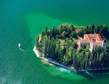
Patmos Island is located on the outskirts of the village of Chemal. This place is truly mesmerizing and enchanting. The stone rocky island is located in the middle of the Katun River and is washed by its turquoise waters. 
The church of St. John the Theologian was built right on the island, the history of which dates back to 1849. You can go to it on a wooden suspension bridge, swinging over the stormy waters of the Katun. 
Before entering the bridge, you can see the face of the Mother of God carved on a rock - the work of one of the nuns who lived in a neighboring village. To the right of the passage to the island, tourists can go down to the banks of the Katun River and admire the magnificence of the landscape from a different angle. 
The Altai Mountains are famous for one of their natural monuments- the confluence of the rivers Biya and Katun. It is at this point that the most powerful and majestic river of Siberia, the Ob, originates. It is worth coming here in order to admire an unusual natural phenomenon, because at the confluence of the waters of two rivers do not mix. Turquoise Katun and blue transparent Biya flow for a long time in two streams, only gradually acquiring a single shade. You can see all this beauty from the island of Ikonnikov, which is considered the border of three rivers. 
The Tavdinsky caves are part of the Turquoise Katun tourist complex and undoubtedly deserve the attention of tourists. They are a network of passages inside the mountain about 5 kilometers long. Caves have many entrances and exits. The Big Tavdinsky cave is especially popular. Inside you can see cave drawings ancient people, whose age is more than 4000 years. For the convenience of visitors, a light is on inside the cave, and the entrance to it is equipped with wooden steps. 

Tourists who prefer beach holiday, be sure to appreciate Lake Aya. In summer, the water in it warms up to a temperature comfortable for swimming. It is equipped with paid and free beaches with sun loungers and umbrellas, in addition, you can ride a boat or a catamaran. The place is very picturesque. From all sides it is surrounded by deciduous and coniferous trees, reflected in the purest water. In the middle of the reservoir there is a small island with a gazebo, which can be easily reached by boat or catamaran. The surroundings of Lake Aya have developed infrastructure. Near it are many recreation centers, hotels, cafes and markets. 
Karakol lakes are located on the highlands of the Ilgo ridge and are a complex consisting of seven reservoirs interconnected by streams and waterfalls. The lakes are located at different levels, and their size decreases as the height increases. The water in all reservoirs is clear and crystal clear. 

The Chemal hydroelectric power station is located near the island of Patmos, so these two excursions can be easily combined. Since 2011, the station has not been used for its intended purpose, but only works as a museum for tourists. In addition to the picturesque views that open from this point, extreme attractions that operate here in the summer deserve the attention of guests. 
The incredibly beautiful place of the Altai Mountains is the valley of the Chulyshman River and the Katu-Yaryk Pass. Steep cliffs, many small and large waterfalls, steep mountain slopes - all this causes genuine delight and pleases the eye. 
This is not the whole list of sights of the Altai Mountains, because every corner here has its own zest, unique and delightful. A trip to these parts will surely charge you with positive energy for a long time and give you unforgettable emotions and impressions.
ALTAI (from the Turkic-Mongolian "altan" - golden), a mountain system in Asia, in southern Siberia and Central Asia, in Russia (the Altai Republic, the Tyva Republic, the Altai Territory), Mongolia, Kazakhstan and China. It is elongated in latitude from 81 to 106 ° east longitude, in longitude - from 42 to 52 ° north latitude. It extends from the northwest to the southeast for more than 2000 km. It consists of high mountains (the highest point is Mount Belukha, 4506 m) and mid-mountain ranges and intermountain basins separating them. In the north and northwest it borders on the West Siberian Plain, in the northeast - on the Western Sayan Mountains and the mountains of South Tuva, in the east - on the Valley Big Lakes, in the southeast - with the Gobi desert, in the south - with the Dzungarian plain, in the west by the valley of the Irtysh river it is separated from the Kazakh hills. Altai is a watershed between the basin of the Arctic Ocean and the endorheic region of Central Asia. Orographically, the Gobi Altai, the Mongolian Altai and the Altai proper, or the Russian Altai, are distinguished. The latter is often identified with the concept of "Altai" and is part of the sub-latitudinal mountainous country of Southern Siberia - mountains, forming a western ending with a latitude of over 400 km, from north to south - about 300 km (see map).
 Relief . The relief of the Russian Altai was formed as a result of a long-term impact of exogenous processes on the growing uplift and is characterized by a wide variety of forms. Most of the ridges of the northwestern or sublatitudinal strike form a fan, diverging in a westerly direction. The exceptions are the ridges of the northern submeridional orientation and the southern periphery. There are a number of vast plateaus (Ukok, etc.), highlands (Chulyshmanskoe, etc.) and mountain ranges (Mongun-Taiga, etc.), as well as large intermountain basins occupied by steppes (Chuiskaya, Kuraiskaya, Uimonskaya, Abaiskaya, Kanskaya, etc. .). High mountain ranges and massifs are located mainly in the east and southeast. Ridges rise above 4000 m: Katunsky (up to 4506 m), Sailyugem (up to 3499 m), Severo-Chuysky (up to 4177 m). The ridges are significant in height: South Chuisky (up to 3936 m), Southern Altai (up to 3483 m), Chikhachev (up to 4029 m), Tsagan-Shibetu (up to 3496 m) and Shapshalsky (up to 3608 m). The isolated Mongun-Taiga massif (3970 m) is distinguished by high-mountain relief. The highlands are characterized by peaked ridges, steep (20-50° and more) slopes and wide valley bottoms filled with moraine or occupied by glaciers. The landslide-scree slopes are widely developed, formed by intensively proceeding gravitational processes. Glacial landforms are widespread: cirques, glacial cirques, troughs, carlings, moraine ridges and ridges. The mid-mountain and low-mountain ranges are located mainly in the west and north of Altai. Among them, the most significant are: Terektinsky (up to 2926 m), Aigulaksky (up to 2752 m), Iolgo (up to 2618 m), Listvyaga (up to 2577 m), Narymsky (up to 2533 m) and Baschelaksky (up to 2423 m) ridges. In the middle mountains, alpine relief features are found fragmentarily. Wide massive interfluves with flattened and plateau-like peaks dominate, where cryogenic processes are developed, leading to the formation of kurums and altiplanation. There are karst landforms. River valleys are often narrow steep gorges and canyons 500-1000 meters deep. The peripheral low mountains of Altai are characterized by a relatively shallow depth of dissection (up to 500 m) and gentle slopes. The valleys are wide, flat-bottomed, with a well-defined complex of terraces. Fragments of ancient leveling surfaces have been preserved on the flat tops. The bottoms of the basins are occupied by sloping plains of proluvial origin and by moraine amphitheatres, bordering the ends of the trough valleys. In the east of Altai, the bottoms of the basins are complicated by thermokarst forms.
 Geological structure and minerals. Altai is located within the Paleozoic Altai-Sayan folded region of the Ural-Okhotsk mobile belt; is a complex folded system formed by Precambrian and Paleozoic strata, intensively deployed in the Caledonian epoch of tectogenesis and the Hercynian epoch of tectogenesis. In the post-Paleozoic time, mountain-folded structures were destroyed and turned into a denudation plain (peneplain). According to the peculiarities of the geological structure and the age of the final folding, the Caledonian Gorny Altai in the northwest (occupies about 4/5 of the entire territory) and the Hercynian Rudny Altai in the southwest and south are distinguished. The anticlinoria of Gorny Altai (Kholzunsko-Chuysky, Talitsky, etc.) are mainly composed of the flyschoid terrigenous series of the Upper Cambrian - Lower Ordovician, overlying Vendian-Lower Cambrian ophiolites, siliceous shale formations, and presumably Precambrian metamorphites, which in some places protrude to the surface. Superimposed depressions and grabens (the largest - Korgon) are filled with molasses of the Middle Ordovician - Lower Silurian and early Devonian. The deposits are intruded by Late Devonian granites. Within Rudny Altai, which has a Caledonian basement, rocks of the Middle Devonian-Early Carboniferous volcano-plutonic association and Late Paleozoic granitoids are widespread. In the Oligocene-Quaternary, Altai experienced uplift associated with regional compression of the earth's crust, caused by the convergence of the lithospheric microplates limiting it (Dzhungar, Tuva-Mongolian). The formation of the mountain structure proceeded according to the type of a large arch, which at the last stages of development was deformed by a system of ruptures, as a result of which a series of block morphostructures in the form of high ridges and depressions separating them formed in the central and southern parts. Instrumental observations record vertical movements of the earth's crust, the speed of which reaches several centimeters per year. Uplifts occur unevenly, are accompanied by overthrusts, which causes the asymmetry of the ridges.
Altai is one of the most seismically active inland regions of the world. One of the largest seismic catastrophes (9-10 points) occurred in the high-mountainous Kosh-Agach region on September 27, 2003. Traces of ancient catastrophes (paleoseismodislocations) are known.
The main wealth of the interior of Altai is the deposits of precious metals and pyrites of lead-zinc-copper-barite ores (Korbalikhinskoye, Zyryanovskoye, etc.), which form the polymetallic belt of Rudny Altai. In Gorny Altai there are deposits of mercury, gold, iron, tungsten-molybdenum ores. The deposits of ornamental stones and marble have long been known. There are thermal mineral springs: Abakan Arzhan, Belokurikhinsky and others. The climate of Altai is continental in the foothills, sharply continental in the inner and eastern parts, which is determined by the position in temperate latitudes and a significant distance from the oceans. The winter is severe and long (from 5 months in the foothills to 10 months in the highlands), which is facilitated by the influence of the Asian anticyclone. The average January temperature is (in the foothills) from -15 to -20°С; in the northeast it is somewhat higher and on the shores of Lake Teletskoye it reaches -9.2°С; in basins where temperature inversions are common, it drops to -31.7°C. The recorded minimum temperature is -60°С (in the Chuya steppe). Strong cooling is associated with the widespread development of permafrost, the thickness of which in some places is up to several hundred meters. Summer is relatively short (up to 4 months), but warm. The average July temperature ranges from 22°C (in the foothills) to 6°C in the highlands; in the basins and southern foothills it is possible to rise to 35-40°С and more. The values of 14-18°С are typical for the middle and low mountains. The frost-free period at an altitude of up to 1000 meters does not exceed 90 days, above 2000 m it is practically absent. Precipitation is associated mainly with western moisture-bearing flows and is distributed extremely unevenly over the territory and over the seasons. The exposure asymmetry is clearly expressed, in which the windward slopes of the ridges, especially the western periphery, receive significantly more precipitation than the inner basins. Thus, in the highlands of the Katun and South Chuya ranges, up to 2000 mm of precipitation or more falls annually, while the Kurai and Chui steppes are one of the most arid places in Russia (up to 100 mm of precipitation per year). The lack of moisture in the hollows is also explained by the drying effect of mountain-valley winds - foehns, especially in winter and autumn. In the low and middle mountains, an average of 700-900 mm of precipitation falls annually. The maximum precipitation occurs in summer. The thickness of the snow cover in the northern and western regions and in the highlands reaches 60-90 cm or more, in the hollows - less than 10 cm, and in years with little snow, a stable cover is practically not formed. Over 1500 glaciers with a total area of about 910 km 2 are known in the Altai mountains. They are most common in the Katunsky, South and North Chuysky ridges. The largest glaciers are Taldurinsky, Aktru (Akturi) and Maashey (Mashey), which are 7-12 km long.

Altai. Katun river.

Rivers and lakes. Altai is dissected by a dense network (several tens of thousands) of mountain rivers, which, according to their diet, belong to the Altai type: they feed on melted snow waters and summer rains; characterized by a long spring flood. Most of the rivers belong to the Ob basin, both of its sources - Katun and Biya - are located in Altai and are its main water arteries. The western spurs are drained by the right tributaries of the Irtysh River, among which the Bukhtarma River stands out. The rivers of the northeastern part of Altai (Abakan, etc.) have a drain into the Yenisei River valley, the southeastern outskirts belong to the drainless region of Central Asia. The total number of lakes in Altai is over 7000, with a total area of over 1000 km2; the largest are Markakol and Lake Teletskoye. Many small (usually 1-3 km 2 or less) ancient glacial lakes often fill picturesque deep trough valleys. In the north of Altai there are karst lakes.
Landscape types . In Altai, the altitudinal zonality of landscapes is well expressed. In the lower landscape zone there are steppes, in the north mainly meadows, with areas of forest-steppes. In the south, the steppes form a wide belt, rising to a height of 1000 meters or more, and in some places have the features of deserts, turning into semi-deserts. Of the mountain-steppe animals, ground squirrels, voles, hamsters, and badgers are common; from birds - steppe eagle, coccyx, kestrel. The appearance of the steppes in the intermountain basins is similar. The gazelle antelope, the Mongolian marmot, the cat's manul, etc. are found there. Leached and podzolized chernozems are developed in the steppe lowlands, and peculiar dry-steppe chestnut and dark chestnut soils are found in the hollows. The insignificant forest-steppe belt is associated with the expositional asymmetry of humidity and illumination, when larch (rarely birch, aspen or pine) grows on the northern slopes of the low mountains, and meadow steppes grow on the southern slopes. The forest belt prevails in the Altai mountains. Mountain taiga forests dominate here: dark coniferous, so-called black taiga from fir, spruce and Siberian cedar pine (or “cedar”), and light coniferous from larch and Scotch pine. Among the inhabitants of mountain forests, taiga animals are typical - bear, lynx, Siberian weasel, squirrel, musk deer, maral, etc.; from birds - capercaillie, hazel grouse, nutcracker, woodpeckers, crossbills. The black taiga on deep podzolic or brown forest soils rich in humus is widespread in the western foothills and in the northeast. Fir forests tend to the middle part of the mountain slopes, cedar taiga - to the upper parts. In dark coniferous forests, the herbaceous layer is made up of large-herb and tall-herb species; the undergrowth is often absent or consists of ground cover (mosses, lichens), to which shrub and shrub layers are added. Larch forests occupy significant areas in the basin of the middle reaches of the Katun River, on the Terektinsky and Kurai Ranges. Pine forests, often of a park type, are distributed mainly along the valleys of the Katun and Chulyshman rivers. In the light coniferous forests, the grass-shrub layer is diverse. Gray forest soils above 1700 m turn into forest-tundra and mountain-tundra. The upper limit of the forest in height ranges from 1600 to 2400 m; sparse taiga grows here with well-developed tall grasses, shrubs and grass-shrub layers. Above - cedar and larch light forests, alternating with thickets of shrubs (derniks) and subalpine meadows. Among the shrubs dominate birch round-leaved, willow, juniper, Kuril tea. Tall grass meadows contain many valuable species: maral root, hellebore Lobel, blueberries, bergenia, etc. Alpine meadows, common in the highlands of western and central regions Altai, alternate with spots of moss-lichen cover or stony placers. There are formations of large-grass, small-grass, grass-sedge and cobresia meadows. The highlands also feature landscapes of subalpine meadows, mountain tundra, rocks, stony placers, glaciers and eternal snows. Most of the highlands are occupied by mountain tundra, which are not distinguished by a wide variety of species. There are meadow, moss-lichen, shrub and rocky tundras. Above 3000 meters there is a nival-glacial belt. Of the animals of the alpine belt, the Altai pika, mountain goat, snow leopard, and reindeer are characteristic. A special type of intrazonal landscapes of Altai are swamps, which are distributed almost everywhere on flat interfluves and plateaus.
Specially protected natural areas. 5 objects of Altai (Altaisky Reserve, a protective strip around Lake Teletskoye, Katunsky Reserve, nature Park Beluga whale and the Ukok Quiet Zone), called the Golden Mountains of Altai, have been included in the list since 1998 world heritage. Natural landscapes and individual natural monuments are also protected in the Markakol Reserve. A number of reserves have been created. For the economy of Altai, see the articles Altai Territory, Altai (Republic of Altai) and Tuva.
History of discovery and research. The first scientific studies of the nature of Altai date back to the 1st half of the 18th century, when ore deposits were discovered in the west and the first copper smelters were built. Russian settlers, mostly runaway factory and state peasants, appeared in the north of Altai in the middle of the 18th century. The first Russian settlements, including those of the Old Believers, began to appear in the 1750-70s, mainly along the valleys of the middle course of the rivers. In the 19th century, the upper reaches of the rivers began to be settled, mainly by Kazakh nomads from China and Kazakhstan. In 1826, K. F. Ledebur studied the flora of Altai. In 1828 alluvial deposits of gold were discovered. In the first half of the 19th century, geological research was carried out by P. A. Chikhachev (1842), G. E. Shchurovsky (1844) and engineers of the mining department. In the 2nd half of the 19th century, numerous expeditions worked in Altai, including the Russian Geographical Societies, the Academy of Sciences, which included V. A. Obruchev, V. V. Sapozhnikov, who studied modern glaciation and the vegetation cover of Altai for a number of years . Since the 1920s, a systematic study of the nature of Altai has been carried out: large-scale topography, and geological surveys, as well as the study of various natural resources in connection with the development of mining, hydropower and agriculture.
Lit .: Kuminova A.V. Vegetation cover of Altai. Novosib., 1960; Mikhailov N.I. Mountains of Southern Siberia. M., 1961; Gvozdetsky N.A., Golubchikov Yu.N. Mountains. M., 1987.
General information
The relief of the Altai Mountains is diverse, it stands out: sections of ancient plains, alpine-type glacial high-mountain relief, mountains of medium (1800-2000 meters) and low height (500-600 meters), deep basins. The ridges are cut by numerous rivers fed by snow. Stormy water flows flow into the lakes famous for their beauty, lying in picturesque valleys. In the Altai Mountains, the Biya and Katun rivers are born, which, merging, form the Ob, one of the deepest and longest rivers in Russia.
The highest ridge of the Altai Mountains is Katunsky. With its snowy slopes, sharp peaks, picturesque lakes and glaciers, this part of the Altai mountain system looks like the Alps.
The Altai Mountains are famous for their caves, of which there are more than 300, especially in the basin of the Katun, Anui and Charysh rivers. Gorny Altai is the land of waterfalls, the highest of which is the 60-meter Tekelu, which flows into the Akkem River.

The weather in the Altai Mountains is unpredictable, so you should not rely on weather forecasts. Being in the mountains on a warm clear day, you can witness the sudden birth of a cloud and visit its very thick.
The climate of the region is sharply continental with cold winters and warm summers. The weather in any particular place depends on its altitude and the prevailing winds. In the Altai Mountains there is both the warmest place in Siberia and its cold pole. The climate is formed under the influence of arctic masses, warm and humid winds of the Atlantic and the hot air of Central Asia. Winter in the region lasts from 3 to 5 months, one of the coldest places is the Chui Valley, where the temperature drops to -32°. Much warmer in southern regions Altai Mountains - for example, in the area of Lake Teletskoye, winter pleases with comfortable ten degrees below zero. In spring and autumn, cold snaps and frosts are frequent, lasting until mid-June in high mountainous areas. The warmest month is July with an average temperature of +14 to +16°; in the highlands - from +5 to +8°, here the temperature drops by 0.6° with an increase in altitude for every 100 meters.
In summer, daylight hours in the region last 17 hours, which is more than in Yalta or Sochi.


Gorny Altai is famous for its rich flora and fauna. In a relatively small area of the region, almost all types of vegetation in Asia, Kazakhstan and the European part of Russia grow. Taiga, steppe, mountain tundra and alpine meadows are located on the Altai Mountains of different heights.
Each natural zone is inhabited by animals adapted to certain environmental conditions. Some of them - bears, deer, sable - roam from one area to another. Elk, musk deer, roe deer, ground squirrel, fox, wolverine, squirrel, and ermine are also found in the Altai Mountains. The rarest animal on Earth lives in the highlands - the irbis (snow leopard), as well as the Siberian goat and the red wolf.
In the Altai Mountains, endemic species have also formed that live only here: mountain turkey, tundra partridge, Altai buzzard. Other birds of the region are the gray goose, mallard duck, gray crane, snipe, owl, nutcracker.


Attractions
Lake Teletskoye is a true pearl in the placer of Altai lakes. The purest waters, framed by mountains and centuries-old cedars, alpine meadows and magnificent waterfalls, remoteness from civilization are the sources of the charm of the famous lake.
teletskoye lakeThe Ukok Plateau is a protected natural area, a place of concentration of barrow burials of various chronological epochs. Local residents believe that the plateau is the threshold of the firmament, "the end of everything", a special sacred place to whom they entrust the bodies of the dead. In many burial mounds, cooled by permafrost, well-preserved household items of great historical value were found. Unique nature the plateau and the surrounding Altai Mountains inspired the artist Nicholas Roerich to create world-famous paintings. In the village of Upper Uimon there is a house-museum of the painter, where you can see his paintings and buy their copies.
Ukok PlateauChemal is a picturesque area of the Altai Mountains, where the Katun carries its waters past rocky mountains that fascinate with their impregnability.
The Katun River near the village of ChemalKarakol lakes - 7 reservoirs amazing beauty, stretching in a chain along the western slope of the Iolgo ridge. To admire the lakes lying at an altitude of 2000 meters, you will have to use horses or a specially equipped vehicle.
Karakol lakesLower Shavlinskoye Lake is located surrounded by mountains Dream, Fairy Tale and Beauty in the vicinity of the village of Chibit. Pagan idols are installed on the shore of the reservoir.
Lower Shavlinskoye LakeThe discovery of the Denisova Cave, located in the valley of the Anui River in the Soloneshsky District, has become a notable event in world archeology. The remains of a 42,000-year-old man were found in the cave. In addition, the oldest cultural layer of habitation of people who lived in a cave 282,000 years ago was discovered here. At the parking lot ancient man more than 80,000 different stone household items, iron products of the XIV century, bronze knives of later periods were found. The cave is accessible to people with any level of physical fitness. Before the eyes of a tourist who is not too lazy to get here, a unique so-called "layer cake" appears, consisting of more than 20 cultural layers formed in different eras of human existence.
Altai cave, one of the deepest and longest in Siberia and Altai, goes down 240 meters, and its length is 2540 meters. This natural attraction, protected as a geological monument of nature, is located in the village of Cheremshanka in the Altai Territory. The Altai cave is actively visited by amateur tourists and professional speleologists.


Mount Belukha, which is part of the Katunsky Range and revered by local residents as sacred, is the most high point Siberia and Altai, towering over the picturesque valleys of the Ukok plateau at 4509 meters. Belukha is located at an equidistant distance from the four world oceans and is the geographical center of Eurasia. Many who have visited Belukha or near it admit that they felt the enlightenment of consciousness and the incredible energy of these places. A special atmosphere reigns here, setting you in a philosophical mood. And this is not self-hypnosis, many scientists claim that powerful bioenergy fields really exist around the mountain. Buddhists believe that somewhere on the top of the mountain there is an entrance to the fabulous land of Shambhala, which only the elite can see. The sources of the main Altai river Katun originate in the Belukha glaciers.
 Chapel of the Archangel Michael at the foot of Mount Belukha
Chui tract - highway Novosibirsk-Tashanta, ending at the borders of Mongolia. After driving along it, you will be able to get to know the Altai Mountains better and see all their diversity.
Chui tractOther sights of the Altai Mountains worthy of attention:
- Lake Aya;
- Multinsky lakes;
- Kucherlinsky lakes;
- Lake Manzherok;
- Rock paintings of primitive people in the Kalbak-Tash tract;
- Scythian burial mounds of Pazyryk;
- Mount Altyn-Tu;
- Patmos Island on Chemal with the Church of St. John the Evangelist;
- The Tsar's mound - a burial site over 2000 years old;
- Valley of the Chulyshman River with numerous waterfalls.
This is only a small part of those natural and man-made miracles, which are rich in the Altai Mountains.
Why go
Adherents sports tourism know and visit the Altai Mountains for several decades. Mountain rivers of Altai are ideal for rafting. Speleologists descend into mysterious caves, climbers storm Mountain peaks, paragliders hover over picturesque landscapes, for lovers hiking nature has prepared countless places of stunning beauty. Equestrian tourism is well developed in Altai, which makes it possible to visit the most inaccessible corners of the region, where you can see the Red Book argali sheep, lakes of unreal beauty, hear the inimitable and heartbreaking cries of marals during the rut.

Fishing in the Altai Mountains traditionally attracts many tourists not only from neighboring regions, but also from the European part of Russia, as well as from abroad. The waters of local rivers are rich in valuable fish - grayling, taimen, whitefish, rainbow trout, burbot, pike and other species.
People go to Altai to get medical treatment and relax in one of the most ecologically clean places on the ground. The seismically active region is rich in healing thermal springs, local radon waters are especially valued. Belokurikha is the most popular Altai balneological resort, famous for its unique microclimate, modern sanatorium and medical facilities and excellent opportunities for active rest. Vacationers get an unforgettable pleasure walking along the health path along the turbulent river Belokurikha, rushing through the forest gorge. At the service of tourists is a chairlift that lifts the guests of the resort to Mount Tserkovka (height 815 meters), from the top of which a stunning view of the Altai expanses opens.
One of business cards The Altai Mountains - deer, on the treatment of antlers which is based on an entire medical industry. Panty - young, non-ossified antlers of deer, cut only from males in June-July. Male individuals provide a unique healing product, rich in amino acids and microelements, a recognized elixir of health and longevity. To obtain valuable raw materials, deer are bred in captivity - the animals live in the vast territory of the deer, where they are protected from predators and poachers. Only once a year the red deer are disturbed in order to cut off their antlers. On the basis of many marals, medical bases have been created, where vacationers improve their health among mountains and forests, enjoying peace and quiet in the bosom of Altai nature.
Visitors are welcome in winter ski resorts Altai - Manzherok, Belokurikha, Turquoise Katun, Seminsky pass.
Lately tourism infrastructure in the mountainous regions of Altai is rapidly developing: modern hotels and recreation centers are being built, new excursion routes new roads are laid and old ones are improved. The number of agencies offering a variety of tours to Altai has grown significantly.


Information for tourists
Finding suitable accommodation in the tourist areas of the Altai Mountains is not difficult - everywhere there are camp sites of different levels of comfort, hotels and boarding houses. Many locals offer accommodation in the private sector for a very moderate fee.
Communication in Gorny Altai is available on all major tourist destinations. It would be useful to have SIM cards of two or three operators with you, because. in some areas, the connection is better with Beeline, and in others - with Megafon.
Going to Altai even at the height of summer, be sure to stock up on warm clothes - in mountainous areas, the night temperature can drop to +5°C.
Popular souvenirs from Gorny Altai are honey, velvet antlers, pine nuts, teas from alpine herbs, original wooden products of local residents, amulets, national musical instruments and household items.


In places that are sacred to the Altaians, one should not indulge in fun, shouting and littering. Do not flatter your pride - do not leave ugly inscriptions "Here was ..." on the man-made and natural sights of Altai. From tourists, local residents expect respect for their land, ancestors and wildlife.
How to get there
The most convenient way to get to Altai from Novosibirsk is by train or bus to Barnaul or Biysk. From these cities there are several flights a day to Gorno-Altaisk and others settlements region. If you are traveling by car, then from Novosibirsk you should go along the M-52 highway (Chuysky Trakt).
Altai, view of the Belukha massifThe Altai Mountains are a wonderful sight of nature. Mountain ranges frighten and cause admiration.
How many of those who want to conquer the snowy slopes, climb the peaks, from where you can view the sprawling beauty of several countries at once.
Altai mountains on the map

Geographical position
The Altai Mountains are located on the territory of Asia, and to be more precise, in Central Asia and Siberia. The mountain system covers several countries at once. It fell on the borders of Russia - in the Altai Territory and the Republic of Altai, China - the Xinjiang Uygur Autonomous Region, Kazakhstan - the East Kazakhstan Region, and Mongolia - the Bayan-Ulgiysky and Khovd aimags.
Flora and fauna
The vegetation of the Altai Mountains is diverse and to some extent unique. On a relatively small area of mountain ranges, you can find almost all types of flora in the European part of Russia, Kazakhstan and Central and North Asia. All this is due to elevation differences (the difference ranges from 350 meters to 4500 meters).

Various altitudinal belts are formed. Each of them has its own flora. Once in the Altai Mountains, you can visit a variety of natural conditions in just a day. Steppe vegetation is widely represented in Altai. Here you can see a variety of shrubs (honeysuckle, sea buckthorn, wild rose), cereals (fescue, feather grass) and other plants.
If we turn to the southeastern region of the mountain system at an altitude of more than 1000 meters, then it will amaze with its semi-desert and scarcity. A completely different Altai appears in its famous forests, rich in flora. The world-famous black taiga is adjacent to the main forests and cedar forests, which occupy more than 30% of the territory of the Altai Mountains.

nature of the Altai mountains photo
At an altitude of 2000 meters, the alpine zone begins. It includes swamps and tundra. Separately, it is worth highlighting the alpine meadows. A huge variety of herbs spreads on them, some of them reach a height of more than one and a half meters.
The flora of Altai is a huge folk "pharmacy" with a large number of medicinal plants. More than 100 plant species are used in the pharmaceutical industry. The most popular and well-known medicinal flower is Maryin root. The bright flowers of this peony burn with fire on the variegated green carpets of countless meadows.
Mountain tundra reigns on the next altitudinal belt. There is no variety of herbs and shrubs here, vegetable world represented by numerous mosses and lichens. In some areas, you can see low-growing willows and birches surrounded by green mosses. You can also meet boulders, entwined with lichens, between which partridge grass sprouts.

snow leopard photo
The fauna of Altai impresses with its richness. Ecologists count here about 90 species of mammals, more than 260 species of birds, 11 different representatives of amphibians and reptiles, and two dozen fish. In the steppe at every step you can come across rodents. Voles, pikas, marmots and jerboas hide here. Foxes, wolves, hare hares live everywhere in the Altai steppes. At an altitude of more than a thousand meters, the fauna is already more diverse, although some representatives of the steppes are still found here.
In addition to them, a wide variety of birds is represented here. Here are the bustard, and the Indian goose, and the gray crane. Birds of prey also soar in the sky: black vultures, griffon vultures, saker falcons. The higher the mountains, the more animals can be found among the trees and rocks. Elk, roe deer, deer are the real decorations of the Altai forests. Closer to the northern territories, the lucky ones can see the rare reindeer.

mountain sheep photo
And in the wilderness of the taiga, dangerous, predatory animals roam: bears, wolverines, lynxes. In alpine meadows, the diversity of animals, in contrast to plant species, is much less. Although it is here that rare animals listed in the Red Book live: snow leopards, argali, mountain goats.
The aquatic fauna is represented by various types of fish. Lakes and rivers of Altai - perfect place fishing for fishermen. Pike, ide, perch, sterlet and minnow swim here. However, the higher the mountains, the more variety water world becomes poorer. The Altai Mountains are the only habitat of the Altai osman.
Characteristics of the Altai Mountains
Who discovered the Altai mountains
AT different countries The mountain was given various names. Like the mountain range itself, its naming is very ancient. It is impossible to determine who exactly discovered the mountains and gave them their real name.

beauty of the Altai Mountains photo
Linguists believe that the word "Altai" comes from a combination of two Turkic words: Alty - "six" and ai - "moons". For various nationalities, the Altai Mountains are “variegated” or “golden” mountains due to the fact that they are rich in bright colorful plants, and the snowy peaks shine in the sunlight.
- Due to the unusual climate in winter in the Altai mountains, peculiar oases without snow cover are formed in some valleys. The temperature in them is usually 10 0 -15 0 degrees higher than in neighboring areas.
- The first mountains formed here 500-600 million years ago. However, due to tectonic processes, their relief was destroyed, and 66 million years ago a mountain range was formed here, which exists to this day.
- natural places, located on the territory of the Altai Mountains (Teletskoye Lake, Altai and Katunsky Reserves, Mount Belukha), were included in the UNESCO heritage list in 1998.
- Experts estimate the reserves of medicinal plants in the mountains in the amount of half a million tons.
- There are numerous mineral deposits in the mountains. However, the extraction of raw materials in these areas is practically not carried out.
- The mountain system is divided into: Altai, Southern Altai, Gobi Altai, Mongolian Altai and Steppe Altai.
- The length of the Museum Cave (the longest in the Altai Mountains) is 700 meters.
Mount Belukha is a symbol of Altai, a transboundary object at the junction of the borders of the Republic of Kazakhstan and Russian Federation. This is the most high mountain Altai and Siberia (4506 m), its slopes are covered with eternal snow and glaciers. This is the realm of snow, ice, thundering avalanches and sparkling waterfalls. Since time immemorial, it has been attracting tourists from all over the world like a magnet.
Excerpts from the photo diary of a trip to Belukha ...
1. We pass the last 50 km to the destination of our trip on foot, otherwise it is impossible to get there (except by helicopter). We carefully cross the bridge over the Belaya Berel River, built in 1938.
The river originates a little higher from the Berel glaciers at the foot of Belukha, flowing out of an ice grotto. It got its name for the milky-white color of the water of dissolved minerals.

2. The bridge across the Belaya Berel River is a rather complex engineering structure that has been serving for more than 75 years. It was built of larch and hammered together with forged nails.

3. Approaching the Lower Camp (at the foot of Belukha) the first thing you hear is the noise of the Kokkolsky waterfall, the largest in Altai. At the confluence with Belaya Berelya, the bed of the Bolshaya Kokkol river approaches a sharp ledge about 80 meters high with a steepness of 60-70 degrees. From here, a water stream over 10 meters wide rushes down from the wall of the Berel spur down with a deafening roar, heard far away.
It does not fall down along the ridge and rocks of the left and right sides, but flows down in narrow swift 'snakes'. When falling from a great height, fine water dust is formed, which ionizes the air in the valley. On sunny days, rising above the waterfall, it is painted with all the colors of the rainbow. A powerful waterfall, a picturesque gorge, overgrown with beautiful cedar and spruce forests, give extraordinary beauty and charm to this corner of Altai nature.

4. The majestically beautiful, impregnable two-headed queen of the Altai mountains, Belukha, is represented by two peaks in the form of irregular pyramids - Eastern (4506 m) and Western Belukha (4435 m).

5. Eastern Belukha (4506 m).

6. Western Belukha (4435 m). The depression between the peaks, called the ‘Belukha Saddle’ (4000 m) also abruptly breaks off to the north to the Akkem glacier (the so-called Akkem wall) and more gently descends to the south to the Katun River.

7. Beluga saddle (4000 m). 'House of the gods', 'Great old man' - this is how the Altaians call Belukha. And according to N.K. Roerich is a mountain about which even deserts whisper. Travelers, contemplating the grandeur of the sparkling two-headed peak, talk about its unearthly beauty, the amazing change of colors at sunset, the amazing closeness of the sky, the live twinkling of stars. The Belaya Berel and Katun rivers originate from the Belukha glaciers. The name comes from the abundant snow covering Belukha from top to bottom.

8. The Belukha region is located on the border of zones of 7-8 magnitude seismic activity. Micro-earthquakes are very frequent here. Their consequences are the breaking of the ice shell, the descent of avalanches and landslides. Faults, cracks and thrusts of rocks testify to the tectonic instability of the territory of Belukha.

9. The climate of the Belukha region is severe with long cold winters and short summers with rains and snowfalls. In winter, negative air temperatures are observed in January down to -48C and remain low even in March down to -5C. In summer, on the top of Belukha, frosts down to -20C are not rare.
On the slopes of the Belukha massif and in the valleys, 169 glaciers are known, with a total area of 150 square kilometers. By the number of glaciers and glaciation, Belukha takes first place on the Katunsky ridge. 6 large glaciers are concentrated here, among them the Sapozhnikov glacier - one of the largest in Altai - 10.5 km long, with an area of 13.2 km2, as well as the Big and Small Berel glaciers, 10 and 8 km long and with an area of 12.5 and 8.9 sq. km. respectively.
The speed of ice movement varies and on average varies from 30 to 50 m per year. The accumulation of snow on steep slopes leads to avalanches. Belukha is one of the intense avalanche regions of Altai.

10. The rivers Katun, Kucherla, Akkem, Idygem originate here. The Belaya Berel River drains the southeastern slope and belongs to the Bukhtarma River basin. Water streams born near the Belukha glaciers form a special Altai type of rivers. The melt waters of glaciers and snows take part in the feeding of the rivers; rainfall is of little importance. Rivers are fast-flowing, often forming waterfalls. The lakes in the area of Mount Belukha lie in deep kars and trough valleys.

Here you can meet rare birds: the Himalayan hawker, the Siberian mountain finches.
11. Himalayan whorl.

12. Siberian mountain finches.

13. From the Lower Camp at the foot of Belukha, you can clearly see the peaks of Vera 2591 m., Nadezhda 2709 m., Lyubov 3039 m., in the bowl of which at an altitude of 2400 m there is Lake Equilibrium, formed by melting glaciers. The purest glacial water, everything is visible to the very bottom (3-4 m). It is interesting to take a photo of Belukha from there in the early morning when it is reflected in the mirror of the lake.
Beluga whale is reflected in the Lake of Equilibrium:

14. From the lake (into a telephoto lens) a grotto is clearly visible, from which the Belaya Berel River flows. It originates from glaciers (Big and Small Berel). then goes under the ice tongue and then flows out of the grotto. The ice is sprinkled with crumbling rubble, which is dangerous to walk on - failures, voids.

15. View of the Katunsky ridge (the Kazakh-Russian border passes through it), Belukha 4509 m, Delaunay peak 3869 m, Urusvati, 3543 m.

16. Mount Urusvati, 3543 m (Sanskrit "Light of the Morning Star").

17. Upper Camp. It is located about 10 km from the Lower Camp (at the foot of Belukha) with a height difference of more than 800 m (we go uphill). Approximately at an altitude of 2600 m there is already snow, an almost clear border between green and white is visible.

18. Upper Camp (Kokkol Mine). Its history goes back to the 30s of the last century. This is a unique mining monument, founded in 1938 on the Kokkol pass, at an altitude of about 3000 m above sea level. In the upper reaches of the Kokkol River, in the ridge part, he discovered fragments of quartz with phenocrysts of wolframite. In 1937, a search party was sent here, which easily discovered a series of parallel, close, thin, steeply dipping (75-85) quartz veins with industrial contents of wolframite and molybdenite.

19. Manual mining of ore began in 1938. At the mine itself on the pass (Upper Camp or Kokkol Mine), barracks, an office, an explosives warehouse, a forge, and a processing factory were built. The Lower Camp was built 9 km to the west near the Kokkol waterfall in the forest zone: a horse yard, an office. The galleries passed along the ore veins. Here the ore was sorted by hand. When the processing plant was built, they began to receive a higher concentrate of ore, which was delivered on horseback to the village of Berel. The mine worked until 1954.
Mine Valley:

20. The Upper Camp of the Kokkol mine is perfectly preserved. Thanks to the cold arid climate, all buildings and equipment: a locomobile, a diesel engine, an enrichment plant are in a satisfactory condition and represent a wonderful museum under open sky. The splendidly preserved concentrating factory is unique, many details of which are made of durable types of wood. There are also ore carts (endovkas), the remains of a Ford car. Only two houses remain from the Lower Camp today.

21. Komsomol members, civilian employees or prisoners of the Gulag worked there, testimonies, sources and links on the Internet were divided almost equally. From myself I will add that I held in my hands old map The General Staff of the USSR Armed Forces, where the "Upper Gulag Camp" was designated. Later army maps (1964, 1985-87 and 2003) already say "Kokkol mine (non-residential)".

22. Kokkol Valley.

23. Aquilegia.

24. "Warm Lake" at the foot of Belukha. Formed by the waters of melting glaciers.

25. Morning in the valley of the Belaya Berel river.