Franz Joseph Island. Franz Josef Land belongs to Russia
Franz Josef Land archipelago in the North Arctic Ocean, in northern Europe. Part of the polar possessions of Russia, is part of the Primorsky district of the Arkhangelsk region. It consists of 192 islands, with a total area of 16,134 km².

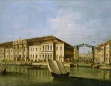
A snapshot of the archipelago from the Terra satellite:

The existence of these islands to the east of Svalbard was predicted by Lomonosov, and later by Schilling and Kropotkin.The latter even presented inRussian Geographical Society in 1871 his expedition project to study them, but the government denied him the funds.
Discovered quite by accident: the Austro-Hungarian expedition led by Karl Weyprecht and Julius Payer on the steam-sailing schooner "Admiral Tegetthoff" (German. Admiral Tegetthoff), which set off in 1872 to open the Northeast Passage, was covered with ice to the northwest of Novaya Zemlya and then, gradually carried away by them to the west, on August 30, 1873, was brought to the shores of an unknown land, which was then Weyprecht and Payer surveyed as far as possible to the north and along its southern margin.

Karl Weyprecht(Carl Weyprecht) (1838-1881) - Austrian naval officer, Arctic explorer and geophysicist.

Julius Johannes Ludovicus von Payer(German Julius Johannes Ludovicus von Payer), better known as Julius Payer(September 1, 1842, Schoenau, now Teplice - August 30, 1915, Feldes, now Bled, Yugoslavia) - Austro-Hungarian explorer of the Arctic. Payer described his journey through the Arctic in the book "725 days in the ice of the Arctic" (1876; translated into Russian in 1935).
Payer managed to reach 82 ° 5 "N (in April 1874) and map this vast archipelago, which seemed to the first explorers to consist of a number of vast islands. Austrian travelers gave the newly discovered land the name of the Austro-Hungarian Emperor Franz Joseph I.

Franz Joseph I- Emperor of the Austrian Empire and King of Bohemia from December 2, 1848, Apostolic King of Hungary from December 2, 1848 to April 14, 1849 (1st time) and from August 13, 1849 (2nd time). Since March 15, 1867 - the head of the dual state - the Austro-Hungarian Monarchy. Ruled for 68 years, his reign became an epoch in the history of the peoples that were part of the Danubian monarchy.
Photos and text Dmitry Cherkasov
Franz Josef Land is an archipelago of islands in the Barents Sea in the very north of Russia. In total, the archipelago consists of 192 islands. I had a chance to visit this place during an expedition to the North Pole aboard the 50 Let Pobedy nuclear icebreaker.
Despite the middle of summer, a day after our departure from the port of Murmansk, we began to come across ice floes:

Very soon, individual ice floes were replaced by whole ice fields. Small icebergs began to come across:

It was in this area that we met the first polar bears. This is not surprising. This combination of ice, land and water is the ideal habitat for this polar predator.

The main prey of the polar bear is the seal. He tracks her down mainly by smell. Very often, the seal hides in hollows in the thickness of the ice. It does not risk showing up on the surface too often. The polar bear, having tracked down the seal, breaks through the ice with all its strength with its front paws and then tries to pull it out. This bear is clearly too late. Someone more fortunate has already dealt with the seal.

Trusting their nose, polar bears are able to climb far north from the nearest land. They have no natural enemies. They are not social animals and prefer to live alone. The only exception is mothers with little cubs. The mother not only feeds the cub at the beginning of its life, but also protects it from adult males. From time to time they attack cubs.

Although they are able to travel tens of kilometers across the icy desert, their favorite habitat is a combination of land, ice fields and open water. Bears swim well in the water, but once again they prefer not to go there. Small cracks in the ice, they can easily jump over.

After a successful hunt, a bear can go weeks without eating. Therefore, they are saturated for the future. A bear that has just had lunch can be easily recognized by its huge belly:

Due to the fact that they have no natural enemies, bears are quite curious. Of course, most of them prefer to stay away from the nuclear icebreaker. Still, the size difference is huge. But some people approach the board with interest and try to see what is happening on the deck:

Especially everyone was pleased with the she-bear with a very small bear cub. They circled around for at least an hour. This was unusual, because most often, at the slightest danger, the female tries to take the baby away. Here they themselves approached the ship and circled the ice floes for a long time:

We watched their relationship with great interest.

Trying to better see what exactly is happening on board, the bear even climbed onto the iceberg. We were practically at eye level. It was probably the most interesting acquaintance with bears during the entire expedition.

In addition to polar bears, we also came across walruses. They are less shy than seals. Although an adult bear is sometimes able to cope with a walrus on land. In the water, they feel quite safe. Often their rookeries are located directly on large ice floes:

However, when approaching big ship most often prefer to dive into the water. They are much more comfortable there, and the speed with which they swim is much more than clumsy movement on land.

Large males are all covered with scars from fights with their relatives. Each large walrus seeks to protect its harem and territory from annoying competitors. Therefore, they have to spend most of their lives in battles.

After two days of travel, we approached the first islands of the archipelago of Franz Josef Land. The existence of the land to the east of Svalbard was predicted by many scientists. Lomonosov spoke about this at one time. One of the most fundamental studies on this issue was made by Pyotr Alekseevich Kropotkin. He even calculated the coordinates of the islands. Unfortunately, no funds were found for the expedition. Therefore, the discovery of the islands was made completely by accident. The Austro-Hungarian expedition of Karl Weyprecht and Julius Payer tried to find the Northeast Passage, but was covered with ice near Novaya Zemlya. Gradually, the drift carried their sailing-steam schooner to the shores of the archipelago. It happened on August 30, 1873. So again open ground It was named after the Austrian emperor Franz Joseph I.

The expedition leader on our trip was the famous Canadian traveler Lorrie Dexter. Based on the ice situation around the island, it was decided to land on the shore by helicopter. The Zodiac inflatable boats could not get close enough to the landing site. We had to go ashore in the area of Cape Flora on the island of Yuri Kuchiev. Interestingly, this island is one of the youngest in the archipelago. It was discovered in 2008 during the expedition of the Yamal icebreaker. Before that, there was an isthmus between the islands and it was part of Northbrook Island. But the crew of the nuclear-powered ship discovered that the isthmus had been washed away by water. Thus appeared on the map new island. It was named after the captain of the legendary icebreaker Arktika. It was under his command that for the first time in the history of mankind a surface vessel reached the top of the world - the North Pole.
On board our icebreaker was an MI-8 helicopter with a crew. Usually such large helicopters are not used for real work at sea. For ice reconnaissance, the more economical and smaller MI-2 is sufficient. However, in our case, it was supposed to disembark people and deliver equipment, so the choice fell on this type of helicopter.

Such tasks are only possible for experienced crews. It is necessary not only to land and take off from a small platform on the ship, but also to correctly choose a landing site and make sure that there is no danger to people around. During landings on shore or ice, the main problem was polar bears. The first thing to do was to make sure they weren't around.

A 300-meter mountain slope rises near the landing site. Thousands of birds nest on it. Mostly guillemots and white gulls. The black dots around the helicopter are just birds in the air.
The first to land on the shore are people ensuring the safety of the rest of the group. Polar bear hunting is prohibited by law. And although they are armed, but the bullets are used to scare away the beast. Nobody shoots to kill. A steel core is used to prevent ricochet. In this way, you can shoot at the stones and drive away the bear. In addition, there are stun grenades.

The place of our landing is Cape Flora. Arctic expeditions have repeatedly landed in this place. For the first time, the crew of the British yacht Eira, under the command of Benjamin Lee Smith, wintered here. His ship was frozen in the ice not far from this place. The researchers managed to build a hut from improvised materials and spend the winter on the island. With the onset of spring, they reached Novaya Zemlya on four sloops, where they were picked up by an English ship sent to search.

British polar explorer and geographer Frederick Jackson established a permanent base here during an expedition to explore Franz Josef Land. On June 17, 1896, the Norwegian explorers Fridtjof Nansen and Hjalmar Johansen came to this base after their unsuccessful attempt to reach the North Pole.

The expeditions of the American Walter Wellman on the ship Fridtjof, as well as the Duke of Arbuzzi on the Stella Polara, stopped at this place:

Many polar expeditions used the reserves of brown coal, which is located on the island. It is interesting that Sedov during the winter at neighboring island on the schooner "Holy Martyr Thomas" did not know anything about it. They were desperate for fuel and dismantled the wooden buildings of the base for this:

This is only a small part of the history of Arctic exploration in this region. The archipelago was officially declared Russian territory during the expedition of Iskhak Ibragimovich Islyamov in search of Sedov in 1914. It was then that here was raised Russian flag.

No less than history, you are amazed at this place by the beauty of northern nature. Summer here is short but very bright. Everywhere underfoot, multi-colored moss covered with flowers. One has only to step on this carpet - and immediately fall into the knee-deep water:

You can constantly hear the unceasing din of birds. The surrounding rocks were chosen by thousands of guillemots and gulls. They nest literally everywhere on these basalt rocks. Only glaciers are free from bird colonies.

Polar bears also come here. Arctic fox, walrus, seal, sea hare, harp seal, narwhal and white whale are also found on the islands. A little further south in the sea you can meet killer whales. But on this visit we did not see any animals. Only old bones.

Back we flew one of the last helicopters. I wanted to walk around the island as long as possible and admire the local beauties. And I must say that we succeeded to the fullest extent.

Almost immediately after takeoff, we felt a strong vibration. The helicopter first lost altitude sharply, and then, with a set, went to a U-turn over a neighboring cape. I sat in the tail and heard how strongly the tail boom creaked.

After some time, we sat down on the platform and it became clear that on takeoff we hit one of the many guillemots with a blade. Because of this, the propeller tip was deformed:

It was decided to transport everyone on rescue boats from the other side of the bay. There was an ice-free coastline. After the evacuation of all people from the island, the helicopter crew will independently try to fly aboard the icebreaker.

Thus, we had a "wonderful" opportunity to admire the beauties of the island to our heart's content during this landing. However, the transition was not very long. Most of the way fell on a hill, so it was relatively easy to go.

The rescue boat slowly approached the shore, measuring the depths so as not to inadvertently damage the propeller. And then, in several flights, we and the equipment were transported on board the ship.

Despite the eventful day, we did not manage to sleep that night. At this time of the year, the sun does not go below the horizon, so it is constantly bright. Passing near the rest of the islands of the archipelago, we constantly met polar bears. Well, how can you miss this opportunity to get to know wildlife the Arctic?

The second time near the islands of Franz Josef Land we visited on the way back, returning from the North Pole.

First of all, we approached the Rubini basalt rock. It is named after the famous Italian tenor and is interesting for its huge bird colony.

Due to its volcanic origin, the coast around the rock is very steep. Therefore, even such a huge ship as our nuclear-powered icebreaker is able to come close to it. This is a very impressive sight. In order to direct such a delicate operation, one of the sailors with a walkie-talkie is on the bow. It constantly reports the distance to the rock and the trend of movement.

The basalt slopes of the island are all dotted with birds. It is also interesting to observe the structure of the rock, which seems to be assembled from separate even columns:

But the main goal of our re-entry was Tikhaya Bay on Hooker Island. It was here that the first Soviet research station on the archipelago was opened in 1929.

Unfortunately, by the time of our visit, no one had lived at the station for several years. All buildings on the territory were mothballed and the only inhabitants here were only polar bears. On board our icebreaker were members of the first expedition to this island in all this time. They were to land and assess the possibility of restoring this polar base. Before landing, they were most worried about the presence of uninvited guests from among the bears. Therefore, all the time before going ashore, they carefully studied the coast and buildings through binoculars.

Although the land is called Franz Josef Land, it belongs to Russia
This is our most land, northern Russian land. The archipelago of Franz Josef Land was declared a Soviet territory 90 years ago, in 1926. Mikhail Lomonosov suspected its existence, but the Austro-Hungarian expedition was the first to land on this shore. At that time, many believed that Franz Josef Land extended to the North Pole.
The history associated with this archipelago is as follows

Franz Josef Land is an archipelago of almost two hundred islands. The closest to the North Pole from Rudolf Island is less than 900 kilometers. Cape Fligeli on this island is the northernmost point of Russia. Most of the archipelago is located north of the 80th parallel. It is very cold here, the average annual temperature is minus 12 degrees Celsius.

The archipelago is part of the polar possessions of Russia, is part of the Primorsky district of the Arkhangelsk region. It consists of 192 islands, with a total area of 16,134 km².
If Mikhail Lomonosov said. that the wealth of Russia will grow in Siberia, Vladimir Putin said that it will also grow in the Arctic.

Image of the archipelago from the Terra satellite
Another brilliant Russian scientist M. V. Lomonosov in a work called “ Short description different trips around northern seas and an indication of the possible passage of the Siberian Ocean to East India ”(1763) suggested the presence of islands east of Spitsbergen.
In 1865, the Russian naval officer, Admiral N. G. Schilling, in his article “Considerations on a New Route in the North Polar Sea”, published in the “Sea Collection”, based on an analysis of the movement of ice in the western part of the Arctic Ocean, suggested the existence of an unknown land , located north of Svalbard.

In the late 1860s, the famous Russian meteorologist A. I. Voeikov raised the question of organizing a large expedition to explore the Russian polar seas. This idea was warmly supported by the geographer (later a revolutionary) Prince P. A. Kropotkin. Observations on the ice of the Barents Sea led him to the conclusion that:
“between Spitsbergen and Novaya Zemlya there is still undiscovered land that extends north further than Spitsbergen and holds ice behind it ... The possible existence of such an archipelago was indicated in his excellent but little-known report on currents in the Arctic Ocean by the Russian naval officer Baron Schilling.”
In 1871, a detailed draft of the expedition was drawn up, but the tsarist government refused funds, and it did not take place.
Franz Josef Land was discovered by the Austro-Hungarian expedition of the great maritime power of the Empire of Austria-Hungary, which had money for the expedition. Under the leadership of Karl Weyprecht and Julius Payer on the steam-sailing schooner Admiral Tegetthoff, the expedition aimed to test the hypothesis of the German scientist August Petermann about the existence of a warm North Polar Sea and a large polar continent.
Austrian travelers gave the newly discovered land the name of the Austro-Hungarian Emperor Franz Joseph I. It is interesting that in Russia, both in pre-revolutionary and Soviet times, the question of renaming the archipelago was raised: first to Romanov Land, and later, after 1917, to Kropotkin Land or Nansen Land, but these proposals were not implemented, the land still bears its original name. In my humble opinion, this archipelago should be called the Lomonosov Land.

It is curious to note that the expedition almost perished and was rescued by Russian coast-dwellers. On May 20, 1874, the crew of the Tegetthoff was forced to abandon the ship and go over the ice to the shores of Novaya Zemlya, where they met with Russian fishermen who assisted in the return of the expedition (Wikipedia).
Since then, only the lazy have not visited this archipelago. But finally. under Emperor Nicholas II, Russia woke up and in 1901 in the summer, the southern and southwestern shores of the archipelago were explored by the first Russian expedition on the icebreaker "Ermak" under the command of Vice Admiral S. O. Makarov. Some sources claim that it was she who first raised the Russian flag here. "Ermak" became the first Russian ship off the coast of Franz Josef Land, the crew was 99 people, including a scientific group. So, the awakened brown Russian bear paid a visit to his distant polar relative, the polar bear.
On August 16, 1914, during the search for the expedition of G. Ya. Sedov, the sailing-motor vessel Greta managed to break through the ice to Cape Flora, on board of which was the head of the search expedition, Captain I Rank Iskhak Islyamov. Islyamov declared the archipelago Russian territory and set the Russian flag over it, made from sheet metal. The artist S. G. Pisakhov, who was on the ship, made sketches of the shores of Franz Josef Land.
The First World War was raging. On September 20 (October 3), 1916, the Russian Foreign Ministry issued an official note on the polar possessions Russian Empire, in which the government listed the polar lands previously known and recently discovered by the Hydrographic Expedition of the Arctic Ocean, which are considered an inseparable part of the empire, among which Franz Josef Land was not mentioned and the initiative of Iskhak Islyamov did not receive legal support from government officials. The question is why? Obviously, traitors were already working, preparing the collapse of the Russian Empire.

Cape Tegetthoff onisland galla
And only with the coming of power of the Bolsheviks after the creation of the USSR on April 15, 1926, the Presidium of the Central Executive Committee by a decree "On declaring the territory of the Union of the Soviet Socialist Republic of lands and islands located in the Arctic Ocean" announced the rights of the Soviet Union to all known and not yet discovered lands and islands, concluded in the sector of the Arctic between the meridians running from the extreme western point of the northern border (the border of the USSR with Finland 32 ° 4'35 E) and the middle Bering Strait(168°49’30 W) in the east to the North Pole.
This automatically meant that Franz Josef Land was officially declared under the full jurisdiction of the USSR. Administratively, the archipelago was included in the Arkhangelsk region. The decree was notified during the preparation of the first transpolar expedition on the airship "Norway". (Wikipedia).

Since 1928, the situation around the archipelago began to worsen. In Italy, preparations began for a purely national Arctic expedition on the airship "Italia", in connection with this, opinions were expressed in the Italian press about the possible upcoming annexation of Franz Josef Land in favor of Italy. "Italia", taking off from the base on Svalbard, passed over the northern tip of the archipelago from west to east in mid-May 1928, during its second Arctic flight, but a disaster occurred on the third flight to the pole. In the subsequent search for the airship, the Soviet Union took an active part, using icebreakers and icebreaking ships.

Stalin took the matter directly. On July 31, 1928, the Council of People's Commissars issued a resolution on strengthening scientific research in the Arctic possessions of the USSR. The first five-year plan for scientific research was being developed, according to which, on Franz Josef Land, as well as on other Arctic lands, it was supposed to build geophysical observatories. Financing scientific works 1.5-2.25% of the income from the Arctic fishing and trade was deducted. Expeditions aimed at securing the most disputed territories for the country ( New Earth and Franz Josef Land) were equipped in advance order, without waiting for the final approval of the plan.
In September 1928, the Krasin icebreaker approached the coast of Alexandra Land and George Land. At Cape Nil, the crew of an icebreaker hoisted the flag of the USSR over the archipelago for the first time.
The fight for the Arctic flared up. On December 19, 1928, the Norwegian government, confirming receipt of the notification of the Decree of the Central Executive Committee of the USSR of April 15, 1926, made a reservation regarding Franz Josef Land: “The Royal Government is not aware that any other interests were known in Franz Josef Land, apart from the economic interests of Norway…”. Plans were discussed in the press to create a permanent Norwegian settlement in the archipelago in 1929, the ships Ballerosen and Tornes-1 were prepared at the expense of Norwegian whalers, and Norwegian naval officers participated in the expedition.

From the Soviet side, accelerated preparations for the expedition began. The project was developed by the Polar Commission of the Academy of Sciences and approved by the government's Arctic Commission on March 5, 1929; O. Yu. Schmidt was appointed leader of the expedition, and the flag of the USSR was presented to the leadership of the expedition in Arkhangelsk at the plenum of the City Council.
On August 30, 1929, the grand opening of the first permanent polar station on Franz Josef Land took place, at 13:30 the USSR flag was raised over the station and the first radiogram was transmitted to the mainland. From that moment on, the archipelago was annually visited by Soviet polar expeditions.
In the 50s. XX century on Franz Josef Land, "points" of the Radio Engineering Troops of the Air Defense Forces of the country were created. These "points" were the northernmost military units of the Soviet Union. They were abolished by the traitors and destroyers of the USSR in the early 1990s.

After the collapse of the Soviet Union, many facilities on the archipelago, as well as equipment and fuel supplies, were abandoned. According to an estimate for 2010, there were about 250,000 barrels of fuel (up to 60,000 tons of oil products) on the islands of Franz Josef Land, stored in inadequate conditions and threatening the ecological situation of the islands. In addition, about 1 million empty barrels were scattered across the islands. Since 2012, a program to clean up the Arctic has begun.


Now Putin has taken over the Arctic affairs. On October 12, 2004, a commemorative plaque was installed on Alexandra Land "as a sign that here, on Nagurskaya, Franz Josef Land, the first Russian base will be created, from which the development of the Arctic in the 21st century will begin." The team of applicants included the FSB of Russia, the Arctic Regional Border Directorate, the Federal Service for Hydrometeorology and Environmental Monitoring, the Interregional Public Organization "Association of Polar Explorers", the Polar Fund, the Scientific Center for the Study of the Arctic and Antarctic "Polyus", the Institute named after G. Ya. Sedov.


The Russian Ministry of Defense in 2016 began construction of the Nagurskoye airfield on Alexandra Land. The length of the concrete runway at the Nagurskoye airfield will be 2,500 meters, and the width will be up to 46 meters, which will make it possible to receive all types of aircraft in service with the Russian Aerospace Forces. Nagurskoye will become the closest stationary airfield to the North Pole; it is planned that IL-78, A-50, A-100, IL-38 and others will be based on the island. Also, Su-27 and MiG-31 fighters will be permanently located at the Nagurskoye airfield, the task of which will be to ensure the full protection of Russia's air borders in the Arctic region.


A border guard on the territory of the Nagurskoe frontier post Photo: Vladimir Baranov / RIA Novosti

The border guards are assisted by specially trained and hired polar bears.

Bears in unsurpassed camouflage for the cause of Vladimir Putin and Russia will tear the jaws of any foreign aggressor. They recognize only one password "Putin", to which they respond with a joyful roar. They shoot at everything moving, and that is what they feed on.
He comes to the bases only for replenishment of ammunition. Trouble-free guards of the Russian Arctic, serving around the clock.
And now Russian leader Vladimir Putin has to remind again: Foreigners have forgotten that Franz Josef Land belongs to Russia. At a big press conference, Russian President Vladimir Putin said that foreigners dispute Russia's ownership of the polar archipelagos in the Russian waters of the Arctic Ocean.
Putin recalled how some time ago he was in the Franz Josef Land archipelago, which is territorially included in the Primorsky district of the Arkhangelsk region. “Foreign guides, showing tourists the nature of these islands, said: the islands used to belong to Russia.” Such an installation was given to the guides by the enemies of Russia. And they still pay extra for such words.
In the West, Putin said, they apparently forgot that Franz Josef Land, like other territories of the Arctic Ocean, is Russian territory.

The Russian Arctic archipelago Franz Josef Land is located east of Svalbard and northwest of the Novaya Zemlya islands, well beyond the Arctic Circle and less than a thousand kilometers from the North Pole. Almost all of the 196 islands of the archipelago are located north of 80°N. sh. The duration of the polar night in these places is 125 days, and the polar day is about 140.
The entire archipelago is divided into three groups. The eastern one - the islands of Wilczek Land and Graham Bell - is separated by the Austrian Strait. The central one - many small islands, including the islands of Rudolph, Jackson, Salisbury and Hooker - is located between the Austrian Strait and the British Channel. Western - the largest islands of the archipelago George Land with a height of 620 m and Alexandra Land - are separated by the British Channel.
The straits and channels 500-600 m deep separating the islands are wide crevices punched by powerful glaciers in the basalt strata. Glaciers appeared on Franz Josef Land about a million years ago, when a period of cooling began in the Northern Hemisphere.
The relief of the islands of Franz Josef Land is represented by elevations that form clusters in the form of a basalt plateau and reach an average height of 400-500 m above sea level. The plateau is covered with ice domes with tongues of glaciers leading to a cliff on the seashore, where icebergs break off from the glacier. On average, the glaciers of the archipelago lose up to 3.3 km 3 of ice per year in the form of icebergs. Glaciers cover over 85% of the archipelago's surface, and the thickness of the ice reaches 100-500 m.
A small ice-free surface is represented by rocky "oases", bare capes and nunataks - rocks protruding above the surface of the ice sheet. Where there is no ice, permafrost reigns, numerous nameless lakes are visible. There are more than a thousand lakes here, and some are quite large: up to 2 km 2 in area and up to 10 m deep. Most of the year the lakes are covered with ice.
The entire archipelago is located in a typical arctic climate zone. In winter, the temperature drops to -52°C, storm winds blow continuously, and snowstorms rage. The temperature could drop even lower, but in winter the force of frost is to a large extent softened by the warm waters of the current.
Discovery history
This northern archipelago was discovered quite by accident, although assumptions about its existence were made by the officer of the Russian fleet N. G. Schilling in 1865 and the famous Russian geographer P.A. Kropotkin in 1870In 1872, the ship of the Austro-Hungarian expedition of J. Payer and K. Weyprecht (researchers were looking for the Northeast Passage, the northern sea route from Atlantic Ocean in Tikhiy) was covered with ice to the northwest of Novaya Zemlya. Drifting in the ice in a westerly direction, in August 1873, the Austrian ship found itself off the coast of a previously unknown land. The Austrians explored the shores, mapped the archipelago and named it after Franz Joseph I, the ruler of the Austro-Hungarian Empire.

Subsequently, the archipelago was visited by the British in 1881-1882 and 1895-1897. They explored almost the entire archipelago and found that it was much larger than the Austrians thought. The famous polar explorer Fridtjof Nansen visited the islands in 1895 and proved that the archipelago does not go further northeast, towards the pole. This was also confirmed by the American-Norwegian expedition of 1898 at the cost of the lives of people who died during wintering.
Beginning in 1901, Russian expeditions began to come here regularly, in particular the expedition of G. Ya. Sedov in 1913-1914, which wintered near Hooker Island. Sedov tried to get to the North Pole, but died and, according to one version, was buried on Rudolf Island.
In 1914, the Russian expedition of hydrograph officer I. Islyamov anchored in the waters of Franz Josef Land, declared the archipelago Russian territory and raised the Russian flag over it.
Geographically, Franz Josef Land is notable for the fact that Cape Fligeli on Rudolf Island is the northernmost point in Russia. In addition, the archipelago is located on the edge of the continental shelf and is the northernmost landmass of Eurasia.
As a legacy from ancient times, when it was warm on the islands and ferns grew here 200 million years ago, among the clay shales and sandstones of the archipelago on Cape Flora, brown coal was left, which was used by polar explorers for wintering. However, due to severe natural conditions there is no industrial activity on the islands.
In Soviet times, research stations worked here, there were stationary points of the radio engineering troops of the air defense, and even a separate detachment that served the ice airfield. Currently, the territory and facilities are abandoned, there is one Ernst Krenkel observatory on Heiss Island, and the islands themselves are visited only by individual tourist groups.
Flora and fauna
This land has a unique position and nature, formed at a distance from the mainland, and a federal nature reserve "Franz Josef Land" with an area of 4.2 million hectares has been created here. The reserve serves the purpose of preserving the unique landscapes of the archipelago, as well as protecting breeding areas for polar bears, marine mammals and bird nesting sites. Among the most valuable natural objects are the paleovolcano of Cape Bryce (Ziegler Island), non-freezing lakes, Atlantic walrus rookeries.The flora of the archipelago is poor in species, vegetation covers no more than 5-10% of the surface. Mosses and lichens predominate here - bright and multicolored. Rarely, but arctic flowers are also found: polar poppy, saxifrage, buttercups.
The polar bear constantly lives in the archipelago, the arctic fox comes here much less often. But the waters surrounding the archipelago have become home to mammals: seals, bearded seals, harp seals, walruses, narwhals and beluga whales. Birds have chosen these places, as no one prevents them from breeding here.
There are 26 species of birds on the archipelago, the most numerous are the guillemot, guillemot, white gull, and burgomaster. Birds form gigantic bird markets: in total, more than 5 million seabirds nest on the islands. The largest bird market within the archipelago - the Rubini Rock has about 55 thousand individuals. Thick-billed guillemots, kittiwakes, little auks, glaucous guillemots, common guillemots nest here. On the southern islands archipelago, you can meet arctic foxes that live under bird colonies.
On Franz Josef Land, many historical sights have been preserved in the form of the remains of wintering camps of expeditions that used the archipelago as a springboard to reach the North Pole. Memorable places marked with tablets, crosses and stone obelisks. At Cape Flora, a ship's felling of 1894 has been preserved, which was used by members of many polar expeditions.
Champ Island is one of the most amazing and mysterious in the archipelago. Scattered over the entire surface of the island are many stone balls of almost perfect shape, ranging in size from a few centimeters to several meters. Such balls are also found in other parts of the world, but such large and round ones cannot be found anywhere else. There is no definite answer to the question of their origin, although the balls are undoubtedly created by nature itself.
general information
Major islands: Wilczek Land, Graham Bell, George Land.
Distance: 900 km from the North Pole, 1220 km from the mainland.
Origin: tectonic.
Major lakes: Cosmic, Icy, Small, Northern, Duck, Shirshova.
Numbers
Area: 16,134 km2.An archipelago of 196 islands.
Length: 375 km from west to east, 234 km from south to north.
Total glaciation area: 13.7 thousand km 2.
The most high point: Mount Wiener Stadt (Forbes glacier. 620 m).
Climate and weather
Arctic.January average temperature:-24°C.
July average temperature: down to -1.4°С.
Average annual rainfall: 200 mm on coasts, up to 500 mm on ice domes.
Wind speed: up to 40 m/s.
Attractions
■ Cape Fligeli (Rudolf Island).■ Franz Josef Land federal nature reserve.
■ Stone balls of Champ Island.
■ Ernst Krenkel Geophysical Polar Observatory (Hayes Island).
■ Bird colonies (Tikhaya Bay, Hooker Island, Rubini Rock).
■ House "Eira" (Bell Island, parking place in 1914 by V. I. Albanov).
■ Walrus rookeries (Nordbrook Island, Stolichki Islands, Appolonov Islands).
■ Sedov Glacier (Hooker Island).
■ Fridtjof Nansen's hut (Jackson Island, 1895-1896).
■ Wooden structure of the Wellman Expedition 1898-1899. (Alger Island).
■ The Tikhaya Bay polar station, 1929-1957. (Hooker Island).
■ Ship felling in 1894 (Cape Flora, Kuchiev Island).
Curious facts
■ The total volume of ice in the Franz Josef Land archipelago is 2,500 km 3, which contains up to 2,250 billion tons of the purest fresh water, which is more than in Lake Baikal.■ Tourists are transported to Franz Josef Land in the summer on icebreakers and landed by helicopter. At the same time, all tourists are required to wear bright yellow-orange jackets so that people do not get lost among the ice.
■ Cape Fligely on Rudolf Island is named after the Austrian cartographer August von Fligely; was discovered on April 12, 1874 by the Austrian polar expedition on the Tegetthoff ship led by J. Payer and K. Weyprecht.
■ The most powerful glaciation can be traced in the southeast and east of each island and the entire Franz Josef Land archipelago. Ice forms only at the tops of ice domes. The archipelago's glaciers are steadily shrinking. Provided that the rate of glacier reduction is maintained, the entire glaciation of Franz Josef Land will disappear in 300 years.
■ The Ernst Krenkel Geophysical Polar Observatory (former name Druzhnaya) on the Heis Island of the Franz Josef Land archipelago is the only observatory in Russia in the region of the geomagnetic polar cap.
■ Austria-Hungary, which fought on the side of Germany in the First world war, was too busy with problems in Europe and did not protest against the declaration of Franz Josef Land as Russian territory.
■ freshwater lake Space on Hayes Island got its name on October 22, 1957 in connection with the first launch of meteorological rockets from the surface of the lake.
■ From the 1930s to the mid-1990s. The archipelago of Franz Josef Land was a closed territory on which military facilities of defense importance were located.
■ According to some reports, during the Second World War in the western part of the island of Alexandra Land there was a German weather station and a base for laying and refueling submarines.
■ According to various sources, up to one million empty barrels of fuels and lubricants have accumulated on the islands of the Franz Josef Land archipelago, the export of which may take at least eight years.
■ Since there are extremely many birds on the islands, they often fall into the blades of helicopters. In this case, tourists have to return to the icebreaker using a boat.
■ In the late 1970s. hydrographs of the Ministry navy found on the island of Lamon Franz Josef Land a letter from one of the leaders of the Austro-Hungarian expedition of 1873-1874. Carl Weyprecht. The letter, wrapped in wax paper and foil, lay for more than a hundred years in a wooden cylinder. It reported on the plight of the expedition. Stored in the Museum of the Arctic and Antarctic in St. Petersburg.
■ In 1929, an expedition on the icebreaking ship "Sedov" led by O.Yu. Schmidt - the future head of the Main Northern Sea Route and an academician - installed a Soviet flag made of iron on Hooker Island and proclaimed the islands the territory of the USSR.
The Franz Josef Land archipelago is a group of islands located in the high latitude Arctic - where permafrost dominates, and the average annual temperature is -12 ° C.

The archipelago is located about a thousand kilometers from the north pole.

Most of Franz Josef Land is covered by glaciers.
Although, one should not confuse FJL with the North Pole. In summer, the temperature here can still reach +12 ° C and the snow usually melts in July.
During this period, the land is exposed, which in just a couple of weeks is covered with mosses and lichens, as well as flowering polar poppies, saxifrage, polar willow and other unpretentious plants.
There are not so many birds here, but they are. These are little auks, guillemots, guillemots, kittiwakes, ivory gulls, glaucous gulls, terns, skuas, eiders, geese, etc.
From animals there is a polar bear and an arctic fox. By the way, did you know that the polar bear belongs to marine mammals and even the Latin name of the polar bear - Ursus maritimus is translated as "sea bear"? There are also seals, bearded seals, harp seals, walruses, narwhals and white whales in the sea.
- a region that is part of a small natural area known as the polar desert zone. You can read about the Arctic desert here.
People have never lived in the FJL for obvious reasons - there are no firewood, no berries, no mushrooms, no deer that can be domesticated, or other animals that can be hunted. There is simply nothing to feed and keep warm here. Even the fin (logs brought by the sea) does not burn here, unlike the fin on the coast. This happens, apparently, because wet firewood simply does not have time to dry, so they all year round completely saturated with ice.
Nevertheless, in the twentieth century, during the period of exploration of the Arctic, weather stations and military camps were built on Franz Josef Land, so it turned out that it was possible to live here with the complicity of civilization. True, all this costs a lot of money, given the high cost of delivering food, fuel and building materials.
HISTORY OF THE ORIGIN OF FRANZ JOSEPH LAND (GEOLOGICAL HISTORY)
 In pre-Paleozoic time on the site of the modern Barents Sea was a huge mainland, extending west to the coast of Greenland. During the Paleozoic period, powerful
mountain building movements, after which most of the current Barents Sea began to represent the mainland with difficult mountainous terrain.
However, erosion and denudation processes gradually cut off the mountainous relief of the mainland, turned it into a flat country,which in the Upper Devonian was taken by the waters of the sea.
At the beginning of the Permian time began to occur bottom lifting marine geosynclinal basins, and their shallowing. Later, mountain building movements appeared, accompanied by vigorous volcanic activity. Mountain building processes were powerful mountain ranges of Novaya Zemlya, the Urals, Kanin and separate parts of Spitsbergen were created. The rise of the shelf is accompanied volcanic eruptions(basalt covers of Svalbard and Franz Josef Land). According to Fridtjof Nansen, on the site of the Barents Sea in the Tertiary time there was a mountainous country, elevated above the modern sea level by 500 m.

It happened in the Quaternary placement of powerful ice sheets. In the maximum phase of glaciation, under the influence of the glacial load, the islands and adjacent areas of the sea bottom sank by 300–400 m. ice sheets die off and complex fluctuations coastline seas. The process of raising the coastline of the Barents Sea continues to this day. The rate of general uplift of the archipelago over the last 7000 years is 1-5 mm/year.
By the way, on Franz Josef Land, you can still find pieces of petrified trees, as well as deer antlers, which suggests that once upon a time, a variety of flora and fauna could grow and live here quite actively.
Deer on Franz Josef Land lived in the Middle Holocene (8-2.5 thousand years ago). Hence it follows that in the Middle Holocene the climate of the archipelago was warmer and the vegetation richer than at present.
The end of the "time of the deer" can be accurately dated. Deer antlers are not found below the 5-meter level. Consequently, the deterioration of the climate, a major advance of glaciers and the extinction of deer on the islands of the archipelago occurred when its shores were 5 m lower, i.e. about 2.5 thousand years ago.
The extinction of reindeer and a major advance of the archipelago's glaciers coincides in time with the receding of the forest zone to the south and the revival of the tundra zone along the northern coast of Russia, as well as with the departure of heat-loving fauna from the coastal waters of Svalbard.
HISTORY OF THE DISCOVERY AND DEVELOPMENT OF THE FRANZ JOSEPH LAND
Theoretical discovery of Franz Josef Land
The first thoughts about the need to explore the northern territories appeared in the 18th century. Mikhail Lomonosov, in his work entitled "A Brief Description of Various Voyages in the Northern Seas and an Indication of a Possible Passage of the Siberian Ocean to the East Indies," suggested finding islands east of Svalbard.
In the late sixties of the nineteenth century, the famous Russian meteorologist A.I. Voeikov raised the question of organizing a large expedition to explore the Russian polar seas. This idea was ardently supported by the well-known geographer and revolutionary, theorist of anarchism, Prince P.A. Kropotkin. Various considerations, and mainly observations of the ice in the Barents Sea, led Kropotkin to the conclusion that “between Svalbard and Novaya Zemlya there is still undiscovered land that extends northward beyond Svalbard and holds ice behind it ... The possible existence of such an archipelago was indicated in his excellent, but little known report on currents in the Arctic Ocean by the Russian naval officer Baron Schilling”. In 1870, Kropotkin drafted an expedition. However, the tsarist government refused to provide funds, and the expedition did not take place.
Practical discovery of Franz Josef Land
Franz Josef Land was discovered by the Austro-Hungarian expedition of Julius Payer and Karl Weyprecht, and was not explored by anyone - the British, the Scots, and the Americans ... But we still got it.
In the photo Julius Payer and Karl Weyprecht. By the way, what kind of fur coat does one of them have? Not from the Red Book polar bear?)

In 1901, the archipelago was explored by the first Russian expedition on the icebreaker Yermak under the command of Vice Admiral Makarov. It is alleged that it was during this period that the Russian flag was first raised on the islands of the archipelago.
In 1914, Iskhak Islyamov visited the archipelago in search of G. Ya. Sedov. He also declared the FJL a Russian territory and raised the Russian flag over it.
In some sources (even in the same notorious Wikipedia) they write that it was Islyamov who declared the FJI Russian territory. Although, the flag had already been set by Makarov before him, therefore, it seems like it turns out that it was Makarov who first laid claim to Russia's rights to Franz Josef Land?
Why such a traveler arose - I do not know, but for the sake of justice I will note both facts - and you yourself decide who was the first.

Islyamov, announcing the acquisition of a new territory for the country, proposed to immediately rename it from Franz Josef Land to the Romanov Lands, but the proposal got stuck in the bureaucratic jungle. And there, first one empire went down in history, and immediately after it another. Iskhak Islyamov became a member of the Helsingfors Muslim Executive Committee of the Army, Navy and Workers, then fought in the White Army, emigrated, and was in charge of the hydrographic part of the Russian naval base in Constantinople.
In 1926, the Central Executive Committee of the USSR adopted a decree according to which all the Arctic islands adjacent to the land borders of the state were declared Soviet territory. Three years later, in the summer of 1929, Otto Schmidt hoisted the Soviet flag on the archipelago during a polar expedition on the icebreaker Georgy Sedov.
In 1929, the Soviet government decided to establish a research station to enhance scientific work in the Arctic. Then in the bay Quiet island Hooker opened the first Soviet research station. In 1931, the archipelago was declared the territory of the Soviet Union, from that time the development of the North Pole by Soviet researchers began. Since then, the archipelago has been visited annually by Soviet polar expeditions.
The Soviet government was going to change the name of Franz Joseph as politically inconvenient and rename the archipelago in honor of the Norwegian explorer Fridtjof Nansen or the Russian anarchist Kropotkin, but the decision was never understood.
In addition to scientists, the military settled down densely on the FJL. In 1936, the first air force base of the USSR was organized on Rudolf Island. And then it went and went ... Nevertheless, in the 90s of the twentieth century, due to well-known economic and political reasons, the military left the archipelago, leaving only the Nagurskoye frontier post, located on the island of Alexandra Land, to function.
The town of the border line branch of military unit 9794, which includes the northernmost airport and the frontier post, is still operating. Not so long ago, they built an excellent two-story building with all amenities: central heating, sewerage, cold and hot water, satellite TV. Inside the complex there is a "winter garden", however, the plants and trees there are artificial. The border guards call this garden "Atrium". There is always a blue sky with cumulus clouds, a playground, a fountain, benches, billiards, an aquarium with live fish, a cinema hall, and table tennis.
Only officers and ensigns serve in Nagurskoye. A third of the border guards live at the outpost with their wives. They fly here from Vorkuta and Arkhangelsk. Dense fogs, low clouds, precipitation and strong winds - this is the weather on Alexandra Land all year round. There were cases of unsuccessful landings, but an amazing thing: in the entire history, not a single person on the island died.
Although, there were victims on other islands. For example, on Graham Bell, where from the 50s to the 90s of the twentieth century there was a unique ice airfield, a couple of times there were plane crashes with victims.
And finally, near the airfield lies AN-12 No. 11994, but no information about him could be found.
On one of the forums, I found information that it was just bad landing The plane landed on the runway too early. But there were no victims - everything ended well.
If we talk about the victims, then, I suspect, the main danger in the Franz Josef Land Archipelago arises from polar bears.
Although, on the other hand, considering great amount bears in the FJL, there were not many deaths because of them. It is believed that Franz Josef Land is a maternity hospital for polar bears, so it can be assumed that the servicemen met with predators constantly. This means that the percentage of accidents is actually not at all high.
Well, again, if people died at the FJL, it was solely because of their own stupidity and negligence. Everything is like everywhere else. For example, here's the story:
But enough of the sad stuff. There are also many good people in Franz Josef Land. And few tourists have the opportunity to see this.
FRANZ JOSEPH LAND IN OUR TIME - PHOTOS, DESCRIPTIONS, MAPS
FJL is the northernmost territory of Russia, located about nine hundred kilometers from the North Pole. Administratively, the archipelago belongs to the Arkhangelsk region. Franz Josef Land coordinates: 80.666667, 54.833333.
Wikipedia says that FJL consists of 192 islands. But it turns out that there were still certain doubts about this, and the 192nd island has not yet been officially “registered” and does not have a separate name.
The letter was sent through the Russian Embassy in Norway to the Russian Foreign Ministry, and from there an order was sent toThe Department of Navigation and Oceanography of the Ministry of Defense of the Russian Federation - to figure out how many islands are actually in the archipelago.
At the same time, after public statements about the “appearance of a new island in Russia,” the deputies of the Arkhangelsk Regional Assembly named the island after the famous polar captain Yuri Kuchiev. And under this name, it already appears on Wikipedia, although the decision of the regional assembly on this issue is not legitimate. So now it remains to complete the opening - to officially recognize and name new geographical features, which will have to be done by the Office of Navigation and Oceanography and the Commission on Geographical Names. On Heiss Island, Vladimir Sanin wrote one of his most famous books, “Don’t Say Goodbye to the Arctic.”
Gall Island, Cape Tegetthoff
Also famous are the rocks at the tip of the island, which rise from the sea itself.
Wilczek Island
Another island associated with the tragic events of the expedition of the discoverers of the archipelago is Wilchek Island. On the high island there is the grave of one of the members of the expedition on the ship "Admiral Tegetthoff" Otto Krish, who was a mechanic on the ship and died in 1873 from scurvy.
Champa Island, Cape Trieste
At Cape Trieste there are unique stone formations of perfectly round shape - spherulites, or concretions. Marcasite concretions are ubiquitous on the cape, and their sizes vary from a few centimeters to several meters in diameter.
The word "nodules" comes from the Latin concretio - "growth". These are concretions, rounded mineral formations in sedimentary rocks. Its composition is sandstone. In the very center of the concretion there is an organic core, around which loose material of continental origin accumulated.
Negri Strait
Islands of Apollonov and Stolichka
These islands do not stand out in any way, and even on nautical charts usually indicated only more large island– Capital, but, as it often happens, all the most interesting is on the island nearby, very small and inconspicuous. In this case, it is the island of Apollo. The island is known for the fact that one of the largest rookeries of Atlantic walruses, listed in the Red Book of the Russian Federation, is located here.
Hooker Island
The abandoned Soviet polar station Tikhaya is located on Hooker Island. The station was opened in 1929 and closed in 1959, but at that time it was the largest Arctic research station in the USSR. Until today, the station has retained its appearance- you can see with your own eyes how polar explorers lived in those days.
Rubini Rock
The largest bird market, where more than 50 thousand birds nest. Among them are kittiwakes, guillemots, guillemots, burgomasters and little auks. Guillemots nest directly on ledges. They do not build nests, but lay their eggs on a bare stone surface. Kittiwake gulls build nests from grasses, lichens and other vegetation, fastening it with their own droppings.
Alger Island
Wilczek Land, Geller Cape
The island contains the remains of Fort McKinley's winter hut and the grave of Bernt Bentsen, who could not survive the winter of 1898-99. He was part of the expedition of Walter Wellman, whose main goal was to conquer the North Pole. The main camp of the expedition was at Cape Tegetthoff of Gall Island. A temporary food warehouse was organized at Cape Geller. It was built from large flat stones and covered with the skins of dead walruses and bears. The temperature inside it in winter kept below 10 degrees. In January 1899, Bernt Bentsen died. However, he was buried only in the spring. Before his death, he asked not to bury him until spring, as he feared that his body would become easy prey for arctic foxes and polar bears.
Rudolf Island, Cape Fligeli
The northernmost cape of the Franz Josef Land archipelago is the extreme island point Russian Federation and Eurasia.
Rudolf Island, Teplice Bay
There is an abandoned meteorological station in the Teplitz bay, which was built in 1931–1932. It was the second station in the archipelago and it worked until 1995.
Jackson Island
Jackson Island and Cape Norway are famous for being where Fridtjof Nansen and Jamar Johansen spent the winter (1895–96). They were returning after an attempt to conquer the North Pole, as they thought, to Svalbard, but they came to Franz Josef Land. They had time to prepare for winter. They shot walruses and polar bears, built a dwelling in which they spent the winter, mostly lying down in one sleeping bag. At Christmas they turned their shirts inside out, and at New Year Nansen told Johansen that after everything they'd been through together, he could just call him Frithjof, not Mr. Nansen, and shook his hand. But they remained on "you". Installed on the cape commemorative sign and there are remnants of the winter hut.
Nordbrook Island, Cape Flora
A distinctive feature of the Franz Josef Land archipelago is the presence of a large number historical sites- the remains of the wintering camps of expeditions that planned to use the archipelago as a launching pad to reach the North Pole, and some expeditions got to the archipelago after failed attempts conquer the top of the planet. Almost all expeditions to Franz Josef Land stopped at Cape Flora of Nordbrook Island.
The island was discovered by the expedition of Benjamin Lee-Smith in 1880. His second expedition of 1881-1182 also wintered here. The winter was forced. Lee-Smith originally planned to spend the winter on Bell Island. In 1894, Briton Frederick Jackson built the first settlement at Cape Flora - Elmwood. The remains of the expedition's buildings can still be seen today.
In 1896, Fridtjof Nansen and Frederick Jackson met at Cape Flora. On June 17, two men approached the cape. No one expected or met them, and they themselves did not expect to meet anyone here. They were the famous polar explorer Fridtjof Nansen and his companion Frederik Jamar Johansen. They were covered from head to toe in soot and mud, and they carried two kayaks and sleds. For three years, Nansen and his 12 satellites planned to conquer the North Pole on the Fram ship, specially built for navigation in ice and wintering.
In 1893, the Fram was frozen into the islands north of the New Siberian Islands archipelago. The ship passed much further south. After two years in the ice, the Fram reached its northernmost geographical location. 700 kilometers from the North Pole, Nansen and Johansen left the ship and went to conquer the pole on dog sledding and kayaks. On 8 April they reached a record latitude of 86 degrees 14 minutes north and were forced to turn south towards the Franz Josef Land archipelago. After wintering on Jackson Island in Cape Norway, they moved south and reached Cape Flora, where they met with Jackson's expedition. This meeting actually saved their lives. At one time, Nansen did not take Frederick Jackson to the Fram, as he believed that the North Pole should be conquered by the Norwegians. Jackson was from the UK.
Administration national park"Russian Arctic" plans to 2020 on the Franz Josef Land archipelago " living history Arctic", which will feature the first Soviet polar station, cars, installations, wildlife, all-terrain vehicles and aircraft.
On the island of Alexandra Land, which is part of the Franz Josef Land archipelago, at the border outpost "Nagurskoye", a church of St. Nicholas the Wonderworker was erected - the northernmost Christian church in the world. It was consecrated in 2012.
In the fall of 2014, on the archipelago of Franz Josef Land to recreate the military infrastructure. On the island of Alexandra Land there are objects of a technical position and administrative-residential, warehouse, economic and park zones, as well as the Nagurskoye airfield. The construction of the administrative and residential complex "Arctic Trefoil" is also underway here, which is the only capital construction facility in the world being built at 80 degrees north latitude.
The material was prepared on the basis of information from RIA Novosti and open sources