Volcanoes of Russia in Kamchatka and the Kuril Islands. Volcanoes of the Kuril Islands and a small arc The highest volcano in the Kuriles
Volcanoes of the Kuril Islands
Volcanic activity is observed exclusively in the Greater Kuril Range, whose islands are mainly of volcanic origin and only the northernmost and southernmost are composed of Neogene sedimentary rocks. These rocks serve here as the foundation on which volcanic structures arose.
Volcanoes of the Kuril Islands are confined to deep faults in the earth's crust, which are a continuation of faults in Kamchatka. Together with the latter, they form one volcanic and tectonic Kurile-Kamchatka arc, convex towards the Pacific Ocean. There are 25 active volcanoes on the Kuril Islands (of which 4 are underwater), 13 are attenuated and more than 60 are extinct. The volcanoes of the Kuril Islands have been studied very little. Of these, the Alaid, Sarychev Fuss, Snow and Milya volcanoes stand out for their increased activity. Volcano Alaid is located on the first northern island (Atlasov Island) and is the most active of all the Kuril volcanoes. It is the highest (2239 m) and beautifully rises in the form of a regular cone directly from the surface of the sea. At the top of the cone in a small depression is the central crater of the volcano. By the nature of the eruptions, the Alaid volcano belongs to the ethno-Vesuvian type. Over the past 180 years, eight eruptions of this volcano and two eruptions from the lateral cone of Taketomi, which formed at the time, are known. eruptions of Alaid in 1934. Volcanic activity on the Kuril Islands is accompanied by numerous hot springs with temperatures from 36 to 100 C. The springs are diverse in form and salt composition and are even less studied than volcanoes.
Underwater volcanic group "Paramushirskaya"
Within this volcanic group the underwater volcano Grigorieva, an underwater volcano located to the west of about. Paramushir and underwater lava cones at about. Paramushir.
Underwater volcano Grigorieva. The flat-topped underwater volcano Grigoriev, named after an outstanding Russian geologist, is located 5.5 km northwest of about. Atlasov (Alaid volcano) (Fig. 17).
It rises from depths of 800-850 m, and its base has grown together with the base of the Alaid volcano. Grigoriev volcano is located on the general line of the north-north-western direction of the location of the side cones of the Alaid volcano.
The dimensions of the base of the volcano along the isobath 500 m 11.5 8.5 km, and the volume of the building is about 40 km 3 . The steepness of the slopes reaches 10o-15o.
The top of the underwater volcano Grigorieva was cut off by abrasion and leveled to a level of 120-140 m (Fig. 18), which practically corresponds to the sea level in the Late Pleistocene. In the southern part of the peak, rocky ledges were noted, rising to a depth of 55 m. Apparently, these rocky ledges represent a prepared neck.
Judging by the records of continuous seismic profiling, the volcanic edifice is composed mainly of dense volcanic rocks.
An intense magnetic field anomaly with a amplitude of more than 1000 nT is confined to the underwater volcano Grigoriev (see Fig. 18). All rock ledges, marked in the southern part of the flat top, are clearly fixed in the magnetic field by the presence of local anomalies. The volcanic edifice is magnetized in the direction of the current magnetic field.
During the dredging of an underwater volcano, basalts were raised, varying in composition from very low-silica to high-silica varieties. The remanent magnetization of these basalts varies in the range of 7.3-28.5 A/m, and the Koenigsberger ratio - in the range of 8.4-26.5.
Data from echo sounding, continuous seismic profiling, hydromagnetic surveys, and measurements of the magnetic properties of dredged samples suggest that the entire edifice of the underwater volcano Grigoriev is composed of dense basalts.
The presence of a pre-Holocene 120-140 meter terrace and the magnetization of the volcanic edifice in the direction of the modern magnetic field allows us to estimate the age of the formation of the volcano in the range of 700-10 thousand years ago.
An underwater volcano to the west of about. Paramushir. In 1989, during the 34th and 35th cruises of the R/V Vulkanolog in the rear part of the Kuril arc, 80 km west of the island. Paramushir was discovered and studied in detail previously unknown underwater volcano.
This submarine volcano is located at the intersection of the Atlasov trough with the continuation of the transverse structure of the 4th Kuril trough. Like the Belyankin and Edelstein underwater volcanoes, it is located far in the rear of the Kuril Island Arc and is 280 km away from the axis of the Kuril-Kamchatka Trench.
The volcano is located on a gentle slope of a trough, rising 650–700 m above the surrounding bottom of the Sea of Okhotsk (Fig. 19). Its base is slightly elongated in the northwest direction and measures ~ 6.5 7 km. The top of the mountain is complicated by a number of peaks. The negative shape of the relief encircles the base of the volcano in an almost closed ring.
In the vicinity of the volcano, there are no extended scattering horizons in the sedimentary section. Only at the very base, an unextended "acoustically muddy" wedge sometimes stands out, apparently due to the accumulation of detrital material and landslide sediments. The position in the section of this “acoustically muddy” wedge corresponds to the estimated time of the formation of the volcano, which, according to the NSP, is 400-700 thousand years.
The structural features of the sedimentary cover indicate that the magma breakthrough to the bottom surface here was not accompanied by a large-scale accumulation of volcanic-sedimentary material, and most likely ended with the formation of one or a series of volcanic extrusions. Most likely, the entire building is composed of volcanic rocks.
At a distance of 5-10 km from the volcano, according to the NSP data, three small (apparently magmatic) bodies were identified that did not reach the bottom surface. Overlying sediments are folded into anticlinal folds.
The anomalous field (T) a in the area of the underwater volcano is characterized by positive values. Only in the northwestern part of the study area, negative field values with an intensity of up to -200 nT are noted. The areas of positive and negative values of the magnetic field are separated by a linear zone of high gradients, which strikes northwest. The horizontal field gradient in this zone reaches 80–100 nT/km. A positive anomaly of the magnetic field with an intensity of up to 400-500 nT is associated directly with the volcanic edifice. Near the summit part of the structure, a local maximum with an intensity of up to 700 nT was noted. The maximum of the anomaly is shifted to the south of the top of the volcano. Marked magmatic bodies that have not reached the bottom surface are not expressed as independent anomalies in the anomalous magnetic field.
The observed pattern of the anomalous magnetic field indicates the direct magnetization of the underwater volcanic structure.
Apparently, the age of the formation of the volcano is not older than 700 thousand years, which is in good agreement with the NSP data.
During the dredging of the near-top part of the mountain, mainly amphibole andesites were raised, with a subordinate amount of pyroxene andesite-basalts and plagiobasalts. In small quantities, there are fragments of granitoids, andesitic pumice, cinders, pebbles of sedimentary rocks, iron-manganese formations, and benthic biota.
Echo sounding, NSP, HMS and geological sampling data suggest that the bulk of the volcanic edifice is composed of rocks of andesite-basalt composition.
Underwater lava cones at about. Paramushir. On a number of cruises of the R/V Vulkanologist and on cruise 11-A of the R/V Akademik Mstislav Keldysh, the study of underwater gas-hydrothermal activity on the northwestern slope of the island was carried out. Paramushir. On cruise 11-A of the R/V Akademik Mstislav Keldysh, either 11 dives of the Pisis VII and Pisis XI, or 13 submersibles, were performed in the study area.
The signal for such a close study of this area was a radiogram sent on March 20, 1982 by the captain of the fishing vessel "Pogranichnik Zmeev" to the newspaper "Kamchatskaya Pravda" that near about. Paramushir "an active underwater volcano was discovered at a depth of 820 m, the extreme height of the ejection is 290 m ...". In April of the same year, on the 13th cruise of the R/V Vulkanolog, acoustic noise was detected at the indicated point, which is clearly manifested in the echo sounder records. Similar records were repeatedly recorded during research from the board of research vessels in the area of active volcanoes and were associated with the action of underwater fumaroles. In its form, the identified interference resembled a torch. Subsequently, when conducting research at the indicated point, acoustic interference on the records of various echo sounders installed on board the R/V Vulkanologist was noted until 1991, when the last specialized cruise No. 40 of this vessel was performed within the RCD.
Prior to the start of research in the area of the "torch" were not known any signs of manifestation volcanic activity. To establish the nature of the "torch" of anomalous water, so many studies were carried out. They made it possible to establish that the “torch” was formed by underwater gas-hydrothermal vents (SGTV), similar to an underwater fumarole, but not directly connected with any volcanic center. Therefore, the application of the term "underwater fumarole" to it would be incorrect.
PGTV is located on the west-north-western slope of about. Paramushir in the rear part of the KKOS, approximately in the middle between the Alaid and Antsiferov volcanoes. Its coordinates are 50o30.8 "N and 155o18.45" E. It is confined to a weakly manifested transverse volcanic zone, represented by almost completely buried extrusive domes or small volcanic cones, stretching from the Chikurachki volcano in a west-northwest direction. On the NSP records, these structures are similar to the side cinder cones of the Alaid volcano, which also have a transverse orientation with respect to the RCD. Most of the buried structures are 0.5-3 km in size at the base and 50-400 m in height. Taking into account that these dimensions are less than the inter-tack distance, excluding a small area around the PGTV itself, it can be assumed that the number of buried structures in the described area is somewhat larger. It should be noted that the buried structures in the KOD area during volcanological expeditions aboard the R/V Vulkanolog were found only in two places: in the PGTV area and near an underwater volcano to the west of the island. Paramushir.
Judging by the HMS data, not all volcanic buried structures have the same structure. Some of them are not expressed in any way in the magnetic field, but are only fixed on the NSP tapes, distinct positive or negative anomalies of the magnetic field are confined to others, and they are, most likely, lava domes or cones, frozen mainly in the sedimentary mass. Non-magnetic cone-shaped structures can be composed of cinder cones or acid rocks.
The largest lava cone is located at the northeastern end of the detailed study area. It is located almost entirely inside the sedimentary sequence, which here has a thickness of more than 1500 m. Only its near-top part rises above the bottom surface, forming a hill 100-120 m high. The recorded depth above the top is 580 m. The dimensions of this structure in its lower part at a depth of 800 -1000 m from the bottom surface reach 5-6 km. The size of the building according to the buried base is 7.5 11 km, the area is ~ 65 km 2, the total height is 1600 m. The steepness of the slopes of the building is 5o-8o. A smaller cone with a base size of ~3 km adjoins it from the south-southwest. Both of these structures are magnetic and form an anomaly, within which two extrema with an intensity of 370 and 440 nT are noted (Fig. 4). The buildings are magnetized in the direction of the modern magnetic field, and the age of their formation is not older than 700 thousand years.
The performed two-dimensional modeling showed that the effective magnetization of the northern cone is 1.56 A/m, and that of the southern cone is 3.7 A/m. Based on the average values of effective magnetization for underwater volcanoes, it can be assumed that the northern cone is composed of andesites, and the southern cone is composed of andesite-basalts.
During PHA dives on the northern cone, plagioclase-hornblende andesites and predominantly homogeneous basalts were sampled.
Comparison of geomagnetic modeling results with geological sampling data suggests that the upper part of this cone is composed of basalts, while the deeper parts are composed of andesites.
Estimates of the age of the northern cone, given in various works, vary within the Neogene-Quaternary.
A small cone, located in the southern part of the detailed work area, has a base size of ~ 1.5 km in diameter. A negative anomaly of the magnetic field with an intensity of -200 nT is confined to it (see Fig. 4). The effective magnetization of this cone is 1.3 A/m, which corresponds to the magnetization of andesitic volcanoes. The negative nature of the magnetic field suggests that the age of formation of this cone is no younger than 700 thousand years.
It should be noted that the PGTV is located in a zone of increased fracturing with a large number of small faults.
PHA subsidence in the PGTV zone showed that the most characteristic landforms in the PGTV area are chaotically located sinkholes and pits. The size of the pits varies from 1 to 10 m in diameter and has a depth of up to 3 m. The distance between the pits is 0.5-2 m.
PGTV is associated with deposits of solid gas hydrates.
Employees of the IO RAS believe that the investigated outlets are gas, and not hydrothermal.
The studies performed have shown that the PGTWs are located within a weakly expressed Quaternary (Neogene-Quaternary?) volcanic zone. They are confined to a zone of increased fracturing and are not directly connected with any volcanic center. The nearest non-magnetic (slag?) cone is located ~ 2 km to the east-south-east of the point of manifestation of acoustic interference.
Underwater volcanic group "Makanrushi".
Within this volcanic group, the contrasting underwater volcanoes Belyankina and Smirnov, named after prominent Russian geologists, were studied. These underwater volcanoes are located in the rear of Onekotan Island (see Fig. 17). The underwater volcano Belyankina is located 23 km northwest of about. Makanrushi (Fig. 21). On navigational charts, prior to the work from the R/V Vulkanolog, two distinctive depths were shown in this area, which could be the depths marked above the peaks of this underwater volcano. Our studies unequivocally showed that the Belyankin underwater volcano has only one peak.
Belyankina volcano has the shape of an isometric cone and rises above the surrounding bottom to a height of about 1100 m. The sharp peak of the volcano is located at a depth of 508 m. Belyankina volcano is located not only outside the mountain structure of the Kuril-Kamchatka island arc, but even on the other side of the Kuril basin - on its northwestern slope. The maximum size of the base of the volcanic edifice is 97 km with an area of about 50 km 2 . The volcano has steep slopes. Their steepness increases in the direction from the base to the top from 15o-20o to 25o-30o. The slopes of the volcano rising above the bottom of the basin are devoid of a sedimentary cover. The base of the overlying volcano is covered by a thick layer of sediments. On the seismograms of the NSP, they correspond to the pattern of the seismoacoustic image, which is generally typical for the sedimentary strata of this region of the Sea of Okhotsk. The volume of the volcanic edifice, taking into account the part covered by sediments, is ~35 km3. The thickness of sedimentary deposits near the volcano exceeds 1000 m. With the available estimates of the sedimentation rate in the Sea of Okhotsk (20-200 m/m.y.), it would take from 1 to 10 m.y. to form this sequence.
Underwater volcano Belyankina clearly manifests itself in a magnetic field. It is associated with a magnetic field anomaly with a swing of 650 nT, the extremum of which is shifted to the southeast of the peak (see Fig. 21). The volcanic edifice has a direct magnetization.
During the dredging of the Belyankin underwater volcano homogeneous olivine basalts were raised. Based on the study of dredged rocks, some authors believe that the volcanic eruptions occurred in underwater conditions, while others - that in land conditions.
Measurement of the magnetic properties of the dredged samples showed that their residual magnetization varies within 10-29 A/m, and the Koenigsberger ratio - within 5.5-16.
To interpret the HMS data, 2.5-dimensional modeling was performed according to the method proposed in the work. As a priori information, the materials of the echo-sounding sounding and NSP were used. One of the most realistic models, in which the best coincidence of the curves of the anomalous and model magnetic fields is observed, is shown in Fig. 6.
It follows from the modeling results that the anomalous magnetic field in the region of the volcano is mainly due to its construction. The role of the deep roots of the volcano is very insignificant. The rocks that make up the volcanic edifice have a direct magnetization and are quite homogeneous in composition, which is in good agreement with the geological sampling data. Modeling performed by two other independent methods gave similar results.
Comparing the modeling results with the NSP and echo sounding data, and taking into account the freshness of the dredged material, it can be assumed that, most likely, the sedimentary sequence was intruded during the formation of the volcanic edifice. The base of the volcano apparently began to form in the Pliocene, while the main part of the edifice formed in the Pleistocene.
The underwater volcano Smirnov is located 12 km north-north-west of about. Macanrushi (see Fig. 21). Its base merges with the base of Macanrushi Island at a depth of about 1800 m. Slopes about. Makanrushi are covered with a thick (up to 0.5 s) cover of "acoustically opaque", probably volcanogenic and volcanogenic-sedimentary deposits. The same deposits overlap the southern part of the base of the Smirnov volcano and, as it were, “flow around” it from the southwest and southeast. From the north, the foot of the volcano is blocked by sedimentary deposits typical for this region of the Sea of Okhotsk, at least 1000 m thick. According to available estimates of the rate of sedimentation in the Sea of Okhotsk, it would take at least 5 million years for the formation of this sequence.
The flat top of the volcano is located at a depth of 950 m and is covered with horizontally layered sediments 100-150 m thick. The maximum size of the base of the volcano is 8 11 km, with an area of ~ 70 km 2, and a flat top - 2? 3 km. The relative height of the volcanic edifice is 850 m, and its volume is about 20 km 3 .
The underwater Smirnov volcano also clearly manifests itself in the magnetic field, and a magnetic field anomaly with an amplitude of 470 nT is confined to it (see Fig. 21). The volcanic edifice has a direct magnetization.
During the dredging of the Smirnov volcano, various rocks were raised, varying in composition from basalts to dacites.
Dredged andesite-basalts have a residual magnetization of 1.5-4.1 A/m and a Koenigsberger ratio of 1.5-6.9, and andesites - 3.1-5.6 A/m and 28-33, respectively.
To interpret the HMS data, 2.5-dimensional modeling was performed according to the method proposed in . One of the most realistic models, in which the best coincidence of the curves of the anomalous and model magnetic fields is observed, is shown in Fig. 6. The discrepancy at the beginning of the profile of the observed and calculated curves of the anomalous magnetic field is due to the influence of the nearby Makanrushi Island. It follows from the simulation results that the anomalous magnetic field in the region of the volcano is due to its structure, and not to deep roots. Despite the heterogeneity of the dredged material, the vast majority of the structure is rather homogeneous in composition of its constituent rocks, which have a direct magnetization. Based on the magnitude of the effective magnetization, such rocks can be high-potassium amphibole-bearing andesites, typical of the rear zone of the Kuril-Kamchatka island arc.
The flat top of the volcano indicates that it once rose to sea level, and then experienced a significant subsidence. Extensive underwater terraces about. Makanrushi are located at depths of about 120-130 m. This practically corresponds to the sea level in the late Pleistocene, i.e. no significant subsidence has occurred in this area since the late Pleistocene. Therefore, we can assume that the lowering of the flat top of the Smirnov volcano to a depth of 950 m occurred before the beginning of the Late Pleistocene. The nature of the relationships between the Smirnov volcano edifice and the sedimentary deposits of the bottom of the Sea of Okhotsk and the deposits of the submarine slopes of Okhotsk Island. Makanrushi suggests that this volcano is one of the most ancient parts of the massif about. Macanrushi. Its age is at least Pliocene.
The Kuriles are the place where the End of the World is located, in any case, that's what it is called cape on Shikotan. The mysterious archipelago keeps a lot of unusual things - this is the Udachny stream with outcrops of quartz gold, the largest waterfall in Russia (140m) Ilya Muromets, and fire-breathing islands with volcanoes and geysers. The Kuriles are compared with a large arboretum, where you can visit various natural areas, and where stone birches, lianas, cedar dwarfs and bamboo thickets, exceeding the height of a person, coexist. Large bird colonies, bears, sables and foxes, whales and dolphins, underwater inhabitants - seals, squids, crabs and starfish - all this can be seen while traveling through these pristine islands.
Thermal springs are attractive for the traveler, volcanoes Alaid, Chikurachki, Fussa, Ebeko and others; and military history will reveal to you the secrets of its past during the Kuril landing in 1945.
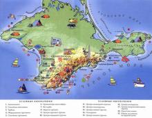
Great Kuril Ridge- one of two parallel groups of islands of the Kuril archipelago. The Krusenstern and Bussol straits divide it into three parts:
The northern group includes the islands of Paramushir, Onekotan, Shumshu, Traps, Atlasova, Shiashkotan and others;
- middle - Simushir, Ketoi, Rasshua, Matua, Ushishir and others;
- the southern group includes the islands of Iturup, Kunashir, Urup.
The territory of the islands is unevenly populated and is uninhabited south of the island of Paramushir and up to the island of Iturup. Concerning tourist routes mainly run along the islands of the Northern and Southern Kuriles. The most popular are Iturup, Paramushir, Shikatan, Shumshu, Kunashir, Matua.
Northern Kuriles
Severo-Kurilsk – main city this group of islands. Until 1946, it was called Kashiwa-bora. The city is located on the shores of the 2nd Kuril Strait in the northeast of Paramushir Island. Its population is 2400 inhabitants (data for 2007). The seiner fleet is based here, there is a heliport, and the total length of roads is about 10 km.
The islands can only be reached by helicopter from Petropavlovsk-Kamchatsky or by PTR ship. The main types of tourism include historical and educational and ecological. The remoteness of the islands is still an obstacle to mass tourism. However, thermal springs, military routes, volcanoes and unusual flora and fauna of the Kuriles are attractions that attract an increasing number of tourists.
The volcanoes of the Kuril Islands are part of the Pacific Ring of Fire.
Ebeko Volcano (1156m). This active volcano is located on Paramushir Island, 7 km from Severo-Kurilsk. Being one of the most active on the Kuril Islands, it is interesting for the presence of several craters. On the southern part of the cone is an active crater that appeared after the eruption in 1965. In the northern part, in the crater is located small lake with greenish water. Known in literature, the North Crater was filled with cinders and volcanic bombs during the last eruption. And another one - the central one - is filled with a lake, which is replenished with water from a snowfield. Once the lake was hot, but later lost contact with underground heat sources. Climbing the Evbeko volcano, you can see a Japanese sulfur plant and many fumaroles. These are holes through which gases rise. Each fumarole is surrounded by intricate figures made of native sulfur. Among the large fumarole fields, the northeastern field stands out, known as the "Roaring Fumaroles" or "White Key".
Volcano Alaid (2339m). It is the highest active volcano in the Kuril Islands. It is located on Atlasov Island, 70 km from Kamchatka and 30 km from Paramushir Island. According to legend, Alaid used to be located in the south of Kamchatka. But other mountains drove him away, because he was the highest among them and blocked the light. Since then, the volcano-island has stood alone. The shape of the Alaid cone is more correct than Mount Fuji. Its feature is the presence of 33 secondary cinder cones on the slopes and at the base. Intense fumarolic activity takes place inside a young 250-meter cinder cone. Alaid is a double stratovolcano with a summit explosive crater 900-1300m in diameter and 200m deep.
Volcano Chikurachki (1816m) – highest point Paramurshir, located in the southwestern part of the island, 60 km from Severo-Kurilsk. In the chain of volcanoes of the Karpinsky Ridge, it is the northernmost. Chikurachki is a stratovolcano standing on an ancient lava base, with a regular cone, the upper half of which is red. It is mainly composed of pyroclastic deposits.
Fussa Volcano (1772m). This complex stratovolcano forms a peninsula in the southwestern part of Paramushir Island, 75 km from Severo-Kurilsk. It is a strongly truncated regular cone with a crater 700 m in diameter and up to 300 m deep. The crater has steep walls, steep in places, and the bottom, divided into two unequal parts, is dotted with snowfields. The volcano offers a breathtaking view of the rocky outcrops of the Arkhangelsky and Belousov mountains, the gentle slopes of the Karpinsky caldera and the saddle between the Lomonosov and Tatarinov volcanoes.
Shumshu and Matua islands. These islands are especially interesting to visit from a historical and educational point of view. They are famous for the catacombs of the war years and preserved fortifications, including numerous trenches, bunkers and rock holes, where the personnel of the garrison of the islands took refuge, and guns were installed.
Southern Kuriles
The most easily accessible and interesting to visit in this part of the Kuriles are the islands of Kunashir and Iturup. You can get to them by air from Yuzhno-Sakhalinsk or by boat from Korsakov. Due to constant fog and weather changes, the An-24 aircraft, which flies three times a week, can wait quite a long time for the right weather. Therefore, the ship is a more reliable way to travel, although due to weather conditions can also change the schedule of arrival to the islands. It is obligatory to visit the South Kuriles to issue a pass in Yuzhno-Sakhalinsk, since the islands are located in the border zone.
Kunashir Island. This is one of the largest and most south island Greater Kuril Ridge with the administrative center in Yuzhno-Kurilsk. In fact, it is a chain of volcanoes - Tyatya, Mendeleev, Golovnin volcano, which are connected by washed sandstone. The Kunashirsky and Treason Straits separate the island from Japan. Many thermal springs and waterfalls are also popular with travelers. Another place worth visiting is the caldera of the Golovnin volcano, where two lakes lie - Hot and Boiling. The latter, formed in the explosive funnel, is considered calling card Southern Kuriles. The lake is famous for the fact that a boiling steam-water jet can suddenly hit from its bottom.
Cape Stolbchaty- This is one of the main attractions of Kunashir. Located on the shores of the Sea of Okhotsk, it was formed in the process of pouring lava into the water column. Tall basalt pillars create ribbed walls, resembling a giant organ. Another highlight of the cape is salmon spawning, which you can follow for hours, watching the fish overcome waterfalls, rapids and streams on the way to the spawning ground.
Iturup Island. This is the most large island archipelago. From the east it is washed by the Pacific Ocean, from the west by the Sea of Okhotsk. Of the 20 volcanoes on the island, 9 are active, and the highest is Stockap, 1634 meters in height. On Iturup, it is recommended to visit the Lion's Mouth Bay and three volcanoes - Berutarube, Atsonopuri and Curly. There are also more than 30 lakes, many waterfalls, hot and mineral springs.
Volcano Berutarube (1222m). In both craters of the volcano, active fumarolic activity takes place. At the top there is a destroyed caldera with a diameter of more than 2 km.
Volcano Atsonopuri (1205m). Due to the high porosity of the slag hallmark islands became a complete lack of water. Atsonopuri is the so-called “volcano within a volcano”, which extends far into the open sea. The correctness of the cone allowed him to take 3rd place in the world after Fujiyama and Vesuvius.
Volcano Curly (991m). It is an active volcano, with a dome in the shape of an isosceles triangle. The height of vertical columns of gas and steam above the crater in calm weather reaches 1 kilometer. In addition, here is the only place in the world where rhenium, a rare earth metal, is mined.
Lion's Mouth Bay. Located in the southwestern part of Iturup, the bay (caldera) resembles a broken ring. The dimensions of the caldera are 7 x 9 km, and its rocky shores rise up to 400 meters. In the strait, at the entrance to the bay, there is a rocky island - Lion Stone, resembling a sleeping lion. The two capes jutting out into the sea are called Fang and Jaw.

Chirip is an active volcano located on Iturup Island, the Chirip Peninsula of the Greater Kuril Ridge, in the north of the Dvuhumpovy Ridge. To the south of it, 4 kilometers away is the Bogdan Khmelnitsky volcano.
It is a Holocene stratovolcano composed of basalts and andesites. Its height reaches 1,589 meters.
The western slopes of Chirip are steep and steep, the height of their plumb lines is 500-600 meters. In the eastern part of its slopes are more gentle and overgrown with elfin. At the top is a crater with a fresh lake.
To date, thermal and fumarole activity has been observed on the volcano. Chirip belongs to the category of active volcanoes, since exits were recorded on it. thermal waters and gas emissions.
Coordinates: 45.37722200,147.91222200
Volcano Kuntomintar
Kuntomintar is one of the active volcanoes on the island of Shiashkotan, located in the Great Kuril Ridge, Sakhalin region in Russia. Kuntominthar is a complex stratovolcano located in a caldera. Its height is 828 meters. The volcano is located in the central region of the Nikonov Peninsula.
In 1927, the last, so far, eruption of Kuntomintara took place. The eruption in 1872, during which the Ainu village was wiped off the face of the earth, is erroneously attributed to him. In fact, the eruption took place on the nearby Sinarka volcano. This was first confirmed by the Soviet scientist Georgy Gorshkov, who stated that the Ainu village was actually located in the northern part of the island of Shiashkotan.
On the this moment Thermal and fumarole activity is recorded on the volcano.
Coordinates: 48.75828200,154.01423000
Volcano Uratman
Uratman is a long-extinct stratovolcano located in the northern part of Simushir Island, in the Great Range of the Kuril Islands. Uratman is a somma-type volcano.
Not far from the volcano is Broughton Bay. Vegetation of the taiga type, thickets of birch, cedar and alder elfin, evergreen Kuril bamboo grows from its top into the bay. Among the animals at the foot of the volcano live foxes, arctic foxes, small rodents and some bird species such as cormorants, gulls, puffins.
According to recent research results and independent expert estimates, the last eruption on Uratman occurred about three thousand years ago.
Coordinates: 47.12083300,152.24611100
Volcano Rasshua
Rasshua is a currently active volcano located on the Rasshua Island of the same name, in the region of the Kuril Archipelago, Sakhalin Region of the Russian Federation.
Rasshua is a complex, pronounced stratovolcano located in a caldera. Its height is 948 meters, and there are two cones in its crater. Herbaceous vegetation, meadows, thickets of alder and dwarf creeping birch forests predominate on the slopes of the volcano.
Only one eruption of Raschois is known and studied, in 1846. In 1957, an increase in the activity of fumaroles was noted on its surface. At the moment, fumarolic and thermal activity is recorded on the volcano.
Coordinates: 47.75805600,153.02472200
Volcano Trident
Trident is a volcano located in the South Kuril region of Russia, Sakhalin region. It is located on the Urup Island of the Great Ridge of the Kuril Islands.
The height of the Trident is 1.220 meters. The volcano is active, but there is no information on recent eruptions. The formation has hot springs and solfataras.
The slopes of the volcano are covered with alder, thickets of Kuril bamboo and elfin cedar. Foxes, small rodents live here, as well as cormorants, gulls and puffins nest.
To date, fumarole and thermal activity, emissions of gases and thermal waters have been recorded on the Trident volcano.
Coordinates: 46.11667300,150.20000300
Volcano Golovnin
On the island of Kunashir there is an active volcano Golovnin. It is the southernmost volcano of the Kuril Islands; its last eruption occurred in 1998.
The volcano is located in a caldera with a diameter of up to 4.7 kilometers, surrounded by a ridge with a height of 541 meters. At the bottom of the caldera there are 2 explosive craters with lakes Boiling and Goryachee and 4 volcanic domes.
Hot springs, steam-gas jets and mud pots beat in the caldera. Their chemical composition includes sulfur dioxide, carbon dioxide, hydrogen chloride and hydrogen sulfide. The chloride-sulphate composition of hot springs and lakes is determined by the fact that gases dissolve when passing through water. Sulfur and its compounds with water metals are constantly falling out - the surface of Lake Boiling is covered with black sulfide-sulfur foam, the shores of the lakes are covered with yellowish-black sand.
The volcano arose at the bottom of the sea, throwing out a large amount of pumice. From this, a large cone grew, but due to new eruptions and the emptying of the magma chamber, as a result of the collapse, in the place where the volcanic mountain was, a volcanic basin arose, which was filled with the waters of the lake. The waters left the caldera into the Sea of Okhotsk, after which extrusive domes grew in the caldera. They grew and exploded. Boiling Lake appeared in one of these craters. All this happened hundreds and thousands of years ago.
Coordinates: 43.84443600,145.50631200
Volcano Nemo
Nemo is a beautiful active volcano on the island of Onekotan, which is part of the Kuril Islands. Despite the largest size of the volcano at 1018 meters, the volcano makes a strong impression on tourists.
The memorable name "Nemo" is given to the volcano in honor of the hero of the novel by Jules Verne. The English captain Henry Snow gave the name to the volcano, as well as to other places on the island. Paganel Bay, Blakiston Bay, and Cape Camberlain have "Jullvernian" names.
Silence and tranquility reign in the Nemo Volcano area. This is a great place for ecotourism. People do not live on the island in the area of \u200b\u200bthe Nemo volcano, but foxes live.
Coordinates: 49.66051700,154.80749100
Volcano Karpinsky
Karpinsky Volcano is an active volcano on the Paramushir Island of the Greater Kuril Ridge in the Sakhalin Region. It is located in the southern part of the Karpinsky Ridge. The height of the volcano is about 1345 meters. By age, it belongs to the era of the Upper Pleistocene - Holocene. It was named after the geologist A.P. Karpinsky.
The volcano consists of two gentle cones with craters. It is composed of basaltic andesite and andesite rocks. The volcano erupted in 1952. Thermal and fumarolic activity is observed today. In the eastern part of the volcano, fountains of liquid sulfur and hot gases come out. Jets of hydrogen sulfide and sulfuric gases - solfataras form sulfur cones, the height of which reaches 3-5 meters. The slopes of the volcano are cut by traces left after ancient glaciers.
Coordinates: 50.13003600,155.37001400
Volcano Krenitsyn
The Krenitsyn Volcano is not just an active volcano located on the Kuril island of Onekotan in Sakhalin. It is the largest volcano in the world with a height of 1324 meters. It is five times the size of the Eiffel Tower and nearly twice the size of the high skyscraper Burj Khalifa. Therefore, the volcano is worthy of the attention of even the most sophisticated travelers. The stunning nature of Lake Koltsevoe surrounding the volcano and the cleanest air around make a trip to the Kuril Island Onekotan useful for health and makes an unforgettable impression for a lifetime.
Coordinates: 49.42526700,154.69762800
Volcano Raikoke
Raikoke is an active, at the moment, volcano located on the island of the same name, in the northern part of the Greater Kuril Islands, the Sakhalin region of the Russian Federation.
Raikoke is a stratovolcano with a pronounced summit crater. Its height is about 551 meters. The main rock of which the volcano is composed is basalt. The crater of the volcano reaches about 700 meters in diameter, and its depth in some places is 200 meters.
The most famous and studied local eruptions were recorded in 1760, 1778 and 1924. At the moment, the volcano exhibits thermal and fumarole activity.
Coordinates: 48.29305600,153.25000000
Fussa Volcano
Fussa Volcano is located in the Sakhalin Region, on Paramushir Island, which belongs to the Great Kuril Ridge. Forms the Fussa Peninsula southwest coast islands. Named after the mathematician N.I. Fuss. It is a stratovolcano with a crater on top. The height of the volcano is 1772 meters. Age about 40-50 thousand years.
The volcano is composed of such volcanic rocks as andesites, it is a regular truncated cone. The diameter of the crater is about 700 meters, the depth is about 300 meters.
The last major volcanic eruption occurred in 1854. Nowadays it shows fumarolic activity.
Coordinates: 50.26836600,155.24166500
Volcano Curly
Curly is an active volcano located on the Iturup Island of the Great Ridge of the Kuril Islands. It is located in the north of the island, in the center of the Bear Range, two kilometers southwest of the Bear Mountain.
This is a complex stratovolcano composed of two-pyroxene andesites and having several craters. Its height reaches 986 meters.
The dome of the volcano, with a height of 350 meters, resembles an isosceles triangle in its shape. Its southwestern slope is rather steep, while its northeastern slope is almost gentle. At the top there are 2 craters with solfataras. Their bottom is uneven and dissected by bridges due to the fact that the Japanese mined sulfur in them. The southwestern crater has fumaroles. Both craters are separated by a distance of 450 meters.
In 1779 and 1883, eruptions occurred from the volcano, and in 1946 and 1999, phreatic explosions occurred. To date, fumarolic activity has been observed on Kudryavoy.
In 1992, a rhenium deposit was discovered on the volcano. It is represented by a fumarole field, which is constantly affected by sources of high-temperature deep fluids. And this means that the field is still being formed.
Coordinates: 45.38388900,148.81305600
Smirnov Volcano
Smirnov Volcano is an underwater volcano of the Great Range of the Kuril Islands, located on Kunashir Island, 12 kilometers northwest of Makanrushi Island. It was named after S. S. Smirnov, a famous Russian geologist and academician. The height of its peak is 1189 meters.
The composition of this volcano includes the Rurui stratovolcano and the Smirnov stratovolcano. Rurui is considered the main due to the fact that he is taller.
The southern part of the volcano is overlain by volcanic and volcanic-sedimentary deposits. The northern foot is blocked by sedimentary deposits with a thickness of at least 1,000 meters. At a depth of 950 meters there is a flat top of the volcano, it is covered with horizontally layered sediments 100-150 meters thick.
Coordinates: 44.41972200,146.13472200
Black Volcano
Chernoy Volcano is an active stratovolcano located on Chirpoi Island, in the middle of the Great Ridge of the Kuril Islands.
The Chernoy stratovolcano has a summit crater, its height is 624 meters. It is located in the central part of the island.
The last recorded eruptions took place on the volcano in 1712 and 1857. At the moment, strong thermal and fumarole activity is recorded on the volcano directly in the crater and on its western slope.
The volcano is named after the Russian centurion Ivan Cherny, who described the islands of the Black Brothers group in 1770.
The flora and fauna here is rather scarce and is represented mainly by herbaceous vegetation, thickets of elfin cedar and nesting birds, puffins and cormorants.
Coordinates: 46.52194400,150.86638900
Volcano Snow
Snow Volcano is an active volcano located on Chirpoi Island, one of the islands of the Black Brothers group, in the middle of the Great Ridge of the Kuril Islands.
Snow is a gently sloping stratovolcano, its height is 395 meters, it is located in the southern part of the island.
Only four eruptions of this volcano have been recorded in history, in 1811, 1879, 1960 and 1982. At the moment, its activity is fading rather quickly, and weak thermal and fumarole activity is recorded in the crater and on the slopes.
The volcano is named after the English, famous industrialist G. J. Snow.
The flora and fauna of the Volcano is quite scarce, and is mainly represented by thickets of elfin cedar, as well as nesting birds, gulls and puffins.
Coordinates: 46.51083300,150.86861100
Volcano Ushishir
Ushishir is an active volcano located on the island of Yankich, which is part of the Ushishir group of islands and the ridge of islands of the Kuril archipelago.
The caldera of the volcano has a diameter of about 1.5 kilometers, and its maximum height is 388 meters. The volcano formed about 9400 years ago, later its southern wall was flooded, which filled with water, and was named Crater Bay. In the center of the bay there are two small domes made of andesitic lava. The remaining two older domes are connected by a shallow to the southern wall of the volcano's caldera.
The last recorded eruption of Ushishir took place in 1884. At the beginning of the 21st century, strong thermal and fumarole activity is recorded here.
Coordinates: 47.51222200,152.81444400
Volcano Ekarma
Ekarma is a large active volcano on the island of the same name in the Sea of Okhotsk. The height of the Ekarma volcano is 1170 meters. The volcano last erupted in 1980, but its thermal activity is still recorded.
Ekarma Volcano is a stratovolcano with a central extrusive dome. The volcano occupies most of the territory of the entire uninhabited island of Ekarma. Few tourists come here, and you have a great chance by visiting Ekarma Island to take the best photos alone with nature.
Coordinates: 49.06306900,153.95605100
Volcano Lesser Brother
Lesser Brother is a volcano located in the Sakhalin region, on the Iturup Island of the Great Ridge of the Kuril Islands. It is located in the northeast of the island, in the west of the Bear Range, two kilometers west of the Kudryavy volcano.
It is an active volcano with an extrusive dome with three craters. Its height reaches 562 meters, diameter - 600 - 700 meters. Lesser Brother has the appearance of a cinder cone, which merges with the base of the Kudryavy volcano cone. Its width increases to 1,300 meters due to the fact that near the base the volcano is surrounded by a thick mantle of breccias. There are two craters on the top, which are separated from each other by a distance of 500 meters. The northwestern crater is heavily destroyed, while the southeastern one has a closed contour and a diameter of 70 meters.
The dome of the formation is covered by three relatively recent lava flows. To date, thermal activity has been observed on the volcano.
Coordinates: 45.38361100,148.78333300
Volcano Rurui
Volcano Rurui is located on the island of Kunashir, it is active and belongs to the Great Kuril Ridge. This is a complex stratovolcano, the height of which reaches 1,485 meters.
The crater of the volcano is open to the north; this is the northern end of the linear-cluster volcanoes of the Dokuchaev Ridge. There is no information about historical eruptions, but on the western slopes of Rurui at an altitude of 150-350 meters above sea level, fumarole activity was noticed, in the coastal part - hydrothermal activity.
This volcano also includes the Smirny stratovolcano, but Rurui is considered the main one, since its height is greater.
Coordinates: 44.45416700,146.13944400
Volcano Ebeko
The Ebeko Volcano is located in the north of Paramushir Island in the Sakhalin Region. The height of the volcano is 1156 meters. The volcano has three craters, in which thermal springs, hot lakes and solfataras are located. It is composed of such rocks as basalts and andesites. It is an active volcano, one of the most active in the Kuriles. Ebeko volcano has erupted repeatedly.
Volcanic eruptions have been recorded since 1793. The last activity of the volcano was noted in February 2013, when he threw a cloud of gas to a height of about 200 meters. During eruptions, the main danger is represented by sulfur and hydrogen sulfide vapors, ash emissions, and volcanic mud flows. Many side craters of the volcano are centers of thermal and fumarolic activity
According to studies conducted in the 1950s and 1960s, groundwater extracts elements such as aluminum, iron and manganese from volcanic rocks. Numerous streams flow down the slopes of the volcano, connecting into a river. The river brings to the Sea of Okhotsk approximately 65 tons of aluminum dissolved in water and about 35 tons of iron per day.
Coordinates: 50.68614500,156.01388400
Volcano Tatarinov
Volcano Tatarinov, located in the Sakhalin region, on the island of Paramushir, belonging to the Kuril ridge, was named after Second Major Mikhail Tatarinov. The volcano is located in the northern part of the Karpinsky Ridge, merges with the Chekurachki volcano in the north, and with the Lomonosov volcano in the south. The volcano is located in the northern part of the Karpinsky Ridge. It is an active stratovolcano.
The age of the volcano is attributed to the Upper Pleistocene-Holocene epoch. The height of the Tatarinov volcano is 1530 meters. It is a collection of cones connected to each other. The volcano has lateral craters, several peaks. The last eruption of the Tatarinov volcano dates back to the 17th century. Today it shows thermal activity.
21 active volcanoes are known on the Kuril Islands, of which five stand out for their more active activity, among the most active volcanoes of the Kuril ridge, these include Alaid, Sarychev Peak, Fuss, Snow and Milna.
Among the active volcanoes of the Kuril Islands, the most active volcano is Alaid. It is also the highest among all the volcanoes of this ridge. As a beautiful cone-shaped mountain, it rises directly from the sea surface to a height of 2,339 m. At the top of the volcano there is a small depression, in the middle of which the central cone rises.
It erupted in 1770, 1789, 1790, 1793, 1828, 1829, 1843 and 1858, that is, eight eruptions in the last 180 years.
In addition, an underwater eruption occurred near the northeastern shores of Alaid in 1932, and in December 1933 and January 1934 eruptions occurred 2 km from its eastern shore. As a result of the last eruption, a volcanic island with a wide crater was formed, called Taketomi. It is a side cone of the Alaid volcano. Taking into account all these eruptions, we can say that over the past 180 years, at least 10 eruptions have occurred from the Alaid volcanic chamber.
In 1936, a spit formed between Taketomi and Alaid volcanoes, which connected them. The lavas and loose volcanic products of Alaida and Taketomi are basaltic.
Sarychev Peak is in second place in terms of the intensity of volcanic activity and is a stratovolcano located on the island of Matua. It has the form of a two-headed cone with a gentle slope in the lower part and with a steeper one - up to 45 °, in the upper part.
On the higher (1497 m) peak there is a crater with a diameter of about 250 m and a depth of about 100 - 150 m. There are many cracks near the crater on the outer side of the cone, from which white vapors and gases were emitted (August and September 1946).
On the south side, the cliff surrounds Sarychev Peak in a semicircle, which, most likely, is a remnant of the crest of the original volcano. To the southeast of the volcano are, apparently, small secondary cones.
From the 60s of the XVIII century to the present, its eruptions occurred in 1767, around 1770, around 1780, in 1878-1879, 1928, 1930 and 1946. In addition, there are numerous data on its fumarole activity. So in 1805, 1811, 1850, 1860. he "smoked". In 1924, an underwater eruption occurred near it.
Thus, over the past 180 years, there have been at least seven eruptions. They were accompanied by both explosive activity and outpourings of basaltic lava.
The last eruption occurred in November 1946. This eruption was preceded by a revival of activity of the neighboring volcano Rasshua, located on the island of the same name. On November 4, it began to rapidly emit gases, and a glow was visible at night, and from November 7, an increased release of white gases from the crater of the Sarychev Peak volcano began.
On November 9, at 17:00, a column of gases and black ash rose above its crater, and in the evening a glow appeared that was visible all night. During November 10, ash was thrown out of the volcano and light, but frequent tremors occurred, and an uninterrupted underground rumble was heard, and occasionally thunder peals.
On the night of November 11-12, mainly hot bombs were thrown to a height of up to 100 m, which, falling along the slopes of the volcano, cooled rather quickly. From 22:00 12 to 14 November, the eruption reached its maximum stress. First, a huge glow appeared above the crater, the height of the flight of volcanic bombs reached 200 m, the height of the gas-ash column - 7000 m above the crater. Particularly deafening explosions occurred on the night of the 12th to the 13th and on the morning of November 13th. On November 13, the outpouring of lava began, and side craters formed on the slope.
The eruption was especially beautiful and spectacular on the night of November 13 and 14. Fiery tongues descended from the crater down the slope. The entire top of the volcano, 500 m down from the crater, seemed red-hot from a large amount of ejected bombs, debris and sand. From the morning of November 13 to 2 pm on November 14, the eruption was accompanied by various types of lightning, which almost every minute sparkled in different directions.
The Fussa Peak Volcano is located on the island of Paramushir and is a separate beautiful gkonus, the western slopes of which abruptly break into the Sea of Okhotsk.
Fuss Peak erupted in 1737, 1742, 1793, 1854 and H859, and the last eruption, i.e., 1859, was accompanied by the release of asphyxiating gases.
Snow Volcano is a small low domed volcano, about 400 m high, located on Chirpoy Island (Black Brothers Islands). At its top (there is a crater about 300 m in diameter. In the northern part of the bottom of the crater there is a depression in the form of a well, with a diameter of about 150 m. Numerous lava flows poured out mainly to the south of the crater. Apparently, it belongs to shield volcanoes. It is known an indication without an exact date of the eruption of this volcano in the 18th century.In addition, Snow volcano erupted in 1854, 1857, 1859 and 1879. Miln volcano is located on Simushir Island, is a two-headed volcano with an inner cone 1,526 m high and bordering on the western side parts of the ridge - the remains of a destroyed more ancient volcano, 1,489 m high. Lava flows are visible on the slopes, which in some places protrude into the sea in the form of huge lava fields.
There are several side cones on the slopes, of which one, called the "Burning Hill", acts along with the main cone and, thus, is, as it were, an independent volcano.
There is information about the volcanic activity of the Milna volcano dating back to the 18th century. According to more accurate information, it erupted in 1849, 1881 and 1914. Some of them, in all likelihood, refer only to the eruptions of the Burning Hill.
Less active volcanoes include Severgin, Sinarka, Raikoke and Medvezhiy volcanoes.
The Kuril Islands is a 1200-kilometer chain of 56 islands stretching from the Kamchatka Peninsula to the Japanese island of Hokkaido. They form two parallel ridges, which are called the Greater Kuril and Lesser Kuril.
All islands are part of the Sakhalin region of the Russian Federation. Many of them have rich and picturesque nature. There are many volcanoes here.
There is evidence of fighting with the Japanese in 1945. The economy of a few settlements is mainly associated with fishing and fish processing. These places have a huge tourist and recreational potential. Several islands in the South Kuriles are disputed by Japan, which considers them part of Hokkaido Prefecture.
In the northern part of Iturup Island on the coast of the Sea of Okhotsk, there are unusual volcanic phenomena called the White Rocks. They are composed of pumice or a glass-like porous mass and stretch for 28 kilometers.
The ridges created by nature have a fantastic view and are cut by beautiful canyons. The shore near them is a beach covered with white quartz and black titanomagnetite sand. The sight of such an extraordinarily beautiful natural object leaves a lasting impression.

On one of the islands there is an unusually beautiful bay called Crater. It is a biological reserve. Its uniqueness lies in the isolation of flora and fauna from the surrounding nature. Here, along with those living at the bottom sea urchins Several new animal species have been discovered.
South-facing bay deep 56 meters has a shallow entrance width of 300 meters and protrudes into the island for a kilometer. A 388-meter volcano operates in the bay Ushishir, the picturesque slopes of which are covered with dense vegetation, descending directly to the water.

This island volcano is the highest active volcano on the islands. Its height is 2339 meters and the correct shape of the cone, which is often compared with the outlines of the Japanese volcano Fuji.
At the base and on the slopes there are more than three dozen cinder cones. The volcano is located 70 kilometers from the Kamchatka coast and 30 kilometers from the largest North Kuril island, Paramushir. It is classified as a double stratovolcano, on top of which there is an explosive crater 200 m deep and up to 1300 m in diameter.

The city of Severo-Kurilsk, located on the island of Paramushir, is its administrative center. 2587 people live in it. After the war, fish processing plants operated here on the basis of former Japanese enterprises.
Residential buildings, schools, hospitals, etc. were built. In 1952, a tsunami with a wave height of 10 meters that arose as a result of an earthquake destroyed the city and surrounding settlements. In the 60s of the last century, the city was restored.

In 1982, on some of the islands belonging to the Lesser Kuril Ridge, a federal natural state reserve was founded. Its purpose is to increase the number and conservation of rare birds and marine animals.
Among them are Red Book birds, as well as local sea otters, seals, sea lions, northern fur seals, killer whales, gray dolphins and humpback whales. Most of the reserve is occupied by coniferous and broad-leaved forests. On its territory there are nesting places for sea birds and a rookery for a seal listed in the Red Book.

In the south of the island Iturup a natural reserve has been created, where there are two volcanoes, three mountain ranges, isthmuses, large picturesque lakes and many streams. Spruce and mixed forests covering the island are extraordinarily beautiful. In them great amount mushrooms and berries, there are thickets of bamboo.
There are unique plants like the huge Sakhalin champignon. In Lake Krasivoye, which is 48 meters deep, salmon spawn. You can get to the reserve through a small airport and a pier in Kasatka Bay.

This unique place on the planet got its name due to its annular shape surrounding the Krenitsyn volcano, which is considered one of the largest in the world.
A lake with a volcano is located on a quiet and calm desert island Onekotan. The depth of the reservoir does not exceed a meter. This is perfect place for connoisseurs of untouched nature who admire the surrounding landscapes while climbing a huge volcano.

This small island-volcano with a constantly smoking upper cone has a square shape with a side of 3.7 kilometers.
The island is almost impregnable because of the rockiness, you can moor to it only by boat in one place in the absence of wind and waves. At the same time, you need to focus on a beautiful 48-meter rock. The vegetation is sparse, there are mosses and grasses, alder bushes. Hundreds of thousands of birds gather here for bird markets.

This is the name of the border and southernmost of the Kuril Islands. It is separated from Japan by two straits. The city of Yuzhno-Kurilsk is its main locality. In fact, the island consists of a chain of volcanoes, which bear the names of Golovin, Mendeleev and Tyat.
They are connected by washed sandstone. The island has rich flora and fauna. There are many thermal springs, unique volcanic lakes. One of them - Boiling, is considered the main South Kuril attraction.

This island is the largest in the northern part of the Kuriles. Its length about 120 kilometers, a width of about 30. It has a rich relief, consisting of mountain ranges, which are a chain of volcanoes, some of which are active. There are many grassy meadows, many rivers, streams and lakes.
The forests are predominantly willow. Wild rosemary and rhododendrons bloom beautifully, there are a lot of lingonberries, blueberries and other berries. Salmon fish live in the large river Tukharka. You can meet brown bears, hares, rodents, sea otters, sea lions and seals.

This North Kuril island was an important military facility of the Japanese army. Here was located 8.5 thousandth garrison with aircraft, tanks, guns, mortars, underground fortifications.

This 15 km strait connects the Sea of Okhotsk with Pacific Ocean. He received the name of the Russian naval officer I.F. Kruzenshtern, who first walked along it in 1805 on the Nadezhda sailboat.
The strait is picturesque, there are uninhabited rocky and steep islands along it, and in the center there are the Trap rocks dangerous for sailors. At its narrowest point, it is 74 kilometers wide. With a maximum depth of 1764 meters, there are two 150-meter shallows.

There are unique thermal springs and reservoirs on the slopes of the Baransky volcano. On a rocky plateau there is a geothermal station that generates electricity.
There are geysers, lakes, sulfur streams, baths with boiling mud. In the lake with the name "Emerald Eye" the temperature reaches 90 degrees. It feeds the picturesque four-kilometer-long rapids river Boiling with hot and sour water.
In one place, it ends with an incredibly beautiful 8-meter waterfall, the water temperature in which is 43 degrees.