The lowest height of the Caucasian mountains. Famous mountains of Russia and their height
The Caucasus Mountains are located on the isthmus between the Caspian and Black Seas. The Kuma-Manych depression separates the Caucasus from the East European Plain. The territory of the Caucasus can be divided into several parts: Ciscaucasia, Greater Caucasus and Transcaucasia. In the territory Russian Federation only Ciscaucasia and the northern part of the Greater Caucasus are located. The last two parts together are called the North Caucasus. However, for Russia, this part of the territory is the southernmost. Here, along the crest of the Main Range, passes state border Russian Federation, followed by Georgia and Azerbaijan. Whole system Caucasian ridge occupies an area of approximately 2600 m2, and its northern slope occupies about 1450 m2, while the southern one is only about 1150 m2.
The North Caucasian mountains are relatively young. Their relief was created by different tectonic structures. In the southern part there are folded-block mountains and foothills of the Greater Caucasus. They were formed when deep trough zones were filled with sedimentary and volcanic rocks, which were later subjected to folding. Tectonic processes here were accompanied by significant bends, extensions, ruptures and faults of earth layers. As a result, a large amount of magma poured onto the surface (this led to the formation of significant ore deposits). The uplifts that took place here in the Neogene and Quaternary periods led to the elevation of the surface and the type of relief that exists today. The rise of the central part of the Greater Caucasus was accompanied by the lowering of the layers along the edges of the ridge being formed. Thus, the Terek-Caspian trough was formed in the east, and the Indal-Kuban trough in the west.
Often the Greater Caucasus is presented as the only ridge. In fact, this is a whole system of various ridges, which can be divided into several parts. The Western Caucasus is located from Black Sea coast to Mount Elbrus, then (from Elbrus to Kazbek) follows the Central Caucasus, and to the east from Kazbek to the Caspian Sea - the Eastern Caucasus. In addition, two ridges can be distinguished in the longitudinal direction: Vodorazdelny (sometimes called the main one) and Lateral. On the northern slope of the Caucasus, the Rocky and Pasture Ranges, as well as the Black Mountains, are distinguished. They were formed as a result of the interbedding of layers composed of sedimentary rocks of different hardness. One slope of the ridge here is gentle, and the other breaks off rather abruptly. As you move away from the axial zone, the height of the mountain ranges decreases.

The chain of the Western Caucasus begins at the Taman Peninsula. At the very beginning, it is rather not even mountains, but hills. They begin to rise towards the east. The highest parts North Caucasus covered with snow caps and glaciers. The highest peaks of the Western Caucasus are the Fisht (2870 meters) and Oshten (2810 meters) mountains. The highest part mountain system The Greater Caucasus is the Central Caucasus. Even some passes at this point reach a height of 3 thousand meters, and the lowest of them (Cross) lies at an altitude of 2380 meters. Here are the highest peaks of the Caucasus. So, for example, the height of Mount Kazbek is 5033 meters, and the two-headed dormant volcano Elbrus is indeed the highest peak in Russia.
The relief here is strongly dissected: sharp ridges, steep slopes and rocky peaks prevail. The eastern part of the Greater Caucasus is mainly made up of the numerous ranges of Dagestan (in translation, the name of this region means "mountainous country"). There are complex branching ridges with steep slopes and deep canyon-like river valleys. However, the height of the peaks here is less than in the central part of the mountain system, but still they exceed the height of 4 thousand meters. The uplift of the Caucasus Mountains continues in our time. Quite frequent earthquakes in this region of Russia are connected with this. To the north of the Central Caucasus, where the magma rising along the cracks did not spill onto the surface, low, so-called island mountains formed. The largest of them are Beshtau (1400 meters) and Mashuk (993 meters). At their base there are numerous sources of mineral waters.
The so-called Ciscaucasia is occupied by the Kuban and Tersko-Kuma lowlands. They are separated from each other by the Stavropol Upland, the height of which is 700-800 meters. The Stavropol Upland is dissected by wide and deeply incised valleys, gullies and ravines. At the base of this area lies a young slab. Its structure is made up of Neogene formations covered with limestone deposits - loess and loess-like loams, and in the eastern part there are also marine deposits of the Quaternary period. The climate in this area is quite favorable. Enough high mountains serve as a good barrier to cold air penetrating here. The proximity of the long cooling sea also has an effect. The Greater Caucasus is the border between two climatic zones - subtropical and temperate. On the Russian territory The climate is still temperate, but the above factors contribute to fairly high temperatures.
Mountains of the Caucasus As a result, winters in Ciscaucasia are quite warm ( average temperature in January is about -5°С). This is facilitated by warm air masses coming from the Atlantic Ocean. On the Black Sea coast, the temperature rarely drops below zero (the average January temperature is 3°C). AT mountainous areas the temperature is naturally lower. Thus, the average temperature in the plains in summer is about 25°C, and in the upper reaches of the mountains - 0°C. Precipitation in this area falls mainly due to cyclones coming from the west, as a result of which their amount gradually decreases towards the east.
Most precipitation falls on the southwestern slopes of the Greater Caucasus. Their number on the Kuban Plain is about 7 times lower. In the mountains of the North Caucasus, glaciation is developed, in terms of the area of \u200b\u200bwhich this region ranks first among all regions of Russia. The rivers flowing here are fed by water formed during the melting of glaciers. The largest Caucasian rivers are the Kuban and Terek, as well as their numerous tributaries. Mountain rivers, as usual, are fast-flowing, and in their lower reaches there are swampy areas overgrown with reeds and reeds.
State budgetary educational institution secondary school No. 509 of the Moscow region
city of St. Petersburg
ESSAY
in the discipline "Geography"
on the topic: « Caucasian mountains».
Completed: students of grade 8 "A"
Gaisyonok Julia
Ahmedova Rukiyat
Leader: geography teacher
Kovaleva Natalya Nikolaevna
St. Petersburg 2012
1. Introduction. …………………………………………………………...........3
2.Main part
2.1 Legend about the origin of the Caucasus Mountains………………………...4
2.2 Physical and geographical location………………………………..5
2.3 Climate……………………………………………………………………7
2.4 Rivers and lakes…………………………………………………………...8
2.5 Animal world …………………………………………………………..9
2.6 Plant world…………………………………………………....11
3.Conclusion……………………………………………………………..12
4. References…………..…………………………………….…..13
5..Appendix 1……………………………………………………………14
6.Appendix 2…………………………………………………………….16
1. Introduction
Since ancient times our Russian Parnassus
Drawn to unfamiliar countries,
And most of all, only you, the Caucasus,
It rang with a mysterious mist.
S.A. Yesenin
This is an amazing land, one of the most interesting regions of the globe. Combining unique landscapes, becoming the homeland for hundreds of nationalities, it is truly a unique region of the world. The North Caucasus is my homeland which I love.
The pride of the Caucasus is its mountains! The Caucasus is not the Caucasus without mountains. The mountains are unique, majestic and impregnable. The Caucasus is amazingly beautiful. He is so different. You can look at the mountains for hours.
The Caucasus Mountains are the great division between Europe and Asia. The Caucasus is a narrow strip of land between the Black and Caspian Seas. It strikes with an incredible variety of climate, flora and fauna.
green hills and alpine meadows Caucasus, salt deserts, miniature sand dunes replaced by high mountains. The beauty of Caucasian landscapes is not inferior to any region of the planet.
The mountain range of the Greater Caucasus is a lot of pastures, forests, as well as amazing natural wonders. More than 2 thousand glaciers descend through narrow gorges. The chain of large mountains stretched for almost one and a half thousand kilometers from the northwest to the southeast. The main peaks exceed 5 thousand meters and significantly affect the weather in the regions.
The clouds that form over the Black Sea are pouring rain, running into Mountain peaks Caucasus. On one side of the ridge there is a harsh landscape, and on the other - rough vegetation. Here you can find more than 6 and a half thousand plant species, a quarter of which cannot be found anywhere else in the world.
The purpose of our essay is to study the natural features of the Caucasus Mountains.
The material can be used in geography lessons when studying the topic "North Caucasus".
2. Base part
2.1 Legend of the origin of the Caucasus Mountains
A long time ago, when the earth was still very young, a huge plain stretched on the site of the modern territory of the Caucasus. Huge sled heroes lived here in peace and love. They were kind and prudent, they met with joy both day and night, they knew neither evil, nor envy, nor deceit. The ruler of this people was the gray-haired giant Elbrus, and he had a beautiful son, Beshtau, and his son had a charming bride, the beautiful Mashuki. But they had an evil envious - Kite. And he decided to harm the Narts. He prepared a terrible potion in which he mixed the teeth of a wolf, the tongue of a boar and the eyes of a snake. At a big feast, he poured a potion into all the drinks of the Narts. And, having drunk it, they acquired the greed of a boar, the anger of a wolf, and the deceit of a snake. And from that time on, the happy and carefree life of the Narts ended. The father decided to take the young bride away from his son and, sending him on a hunt, wanted to forcefully marry Mashuki. But Mashuki resisted Elbrus. And in an evil battle she lost her wedding ring. I saw the Beshtau ring and hurried to help the bride. And a terrible battle began not for life, but for death, and half of the Narts fought on the side of Elbrus, and the other half on the side of Beshtau. And the battle lasted for several days and nights, and all the sledges perished. Elbrus chopped his son into five parts, and the son, inflicting the last blow, dismembered the gray head of his father into two halves. Mashuki came out after the battle on the battlefield and did not see a single living soul. She approached her lover and plunged the dagger into her heart. So the life of a great and old people stopped.
And now the Caucasian mountains rise in this place: the helmet from the head of Beshtau is Mount Zheleznaya, the ring of Mashuk is Mount Ring, five peaks are Mount Beshtau, nearby is Mount Mashuk and far, far from others - gray-haired or simply snow-covered handsome Elbrus. [ 2 ]
2.2Physical location
The Caucasus Mountains form a natural border between Europe and Asia, located on the isthmus between the Caspian and Black Seas. The Kuma-Manych depression separates the Caucasus from the East European Plain. The territory of the Caucasus can be divided into several parts: Ciscaucasia, Greater Caucasus and Transcaucasia. On the territory of the Russian Federation, only Ciscaucasia and the northern part of the Greater Caucasus are located. The last two parts together are called the North Caucasus. However, for Russia, this part of the territory is the southernmost. Here, along the crest of the Main Range, the state border of the Russian Federation passes, behind which lies Georgia and Azerbaijan.
The North Caucasian mountains are relatively young. Their relief was created by different tectonic structures. These mountains were formed when deep trough zones were filled with sedimentary and volcanic rocks, which were later subjected to folding. Tectonic processes here were accompanied by significant bends, extensions, ruptures and faults of earth layers. As a result, a large amount of magma poured onto the surface (this led to the formation of significant ore deposits).
Often the Greater Caucasus is presented as the only ridge. In fact, this is a whole system of various ridges, which can be divided into several parts. The Western Caucasus is located from the Black Sea coast to Mount Elbrus, then (from Elbrus to Kazbek) follows the Central Caucasus, and to the east from Kazbek to the Caspian Sea - the Eastern Caucasus. In addition, two ridges can be distinguished in the longitudinal direction: Vodorazdelny (sometimes called the main one) and Lateral. On the northern slope of the Caucasus, the Rocky and Pasture Ranges, as well as the Black Mountains, are distinguished. They were formed as a result of interlayering layers composed of sedimentary rocks of different hardness. One slope of the ridge here is gentle, and the other breaks off rather abruptly. As you move away from the axial zone, the height of the mountain ranges decreases.
The chain of the Western Caucasus begins at Taman Peninsula. At the very beginning, it is rather not even mountains, but hills. They begin to rise towards the east. The highest parts of the North Caucasus are covered with snow caps and glaciers. The highest peaks of the Western Caucasus are the Fisht (2870 meters) and Oshten (2810 meters) mountains. The highest part of the Greater Caucasus is the Central Caucasus. Even some passes at this point reach a height of 3000 meters, and the lowest of them (Krestovy) lies at an altitude of 2380 meters. Here are the highest peaks of the Caucasus. So, for example, the height of Mount Kazbek is 5033 meters, and the two-headed extinct volcano Elbrus is the highest peak in Russia. The relief here is strongly dissected: sharp ridges, steep slopes and rocky peaks prevail.
The eastern part of the Greater Caucasus is mainly made up of the numerous ridges of Dagestan (in the translation of the name of this region means "mountainous country"). There are complex branching ridges with steep slopes and deep canyon-like river valleys. However, the height of the peaks here is less than in the central part of the mountain system, but still they exceed the height of 4 thousand meters. meters. The uplift of the Caucasus Mountains continues in our time. This is associated with fairly frequent earthquakes in this region of Russia. To the north of the Central Caucasus, where the magma rising along the cracks did not spill onto the surface, low, so-called island mountains formed. The largest of them are Beshtau (1400 meters) and Mashuk (993 meters). At their base there are numerous sources of mineral waters.
The so-called Ciscaucasia is occupied by the Kuban and Tersko-Kuma lowlands. They are separated from each other by the Stavropol Upland, the height of which is 700-800 meters.
Fig.1 Dagestan. Red mountain.
2.3Climate
The climate in this area is quite favorable. Quite high mountains serve as a good obstacle to the cold air penetrating here. The proximity of the long cooling sea also has an effect. The Greater Caucasus is the border between two climatic poles - subtropical and temperate. In the Russian territory, the climate is still moderate, but the above factors contribute to high temperatures.
As a result, winters in Ciscaucasia are quite warm (the average temperature in January is about -5 ° C) .This is facilitated by warm air masses coming from the Atlantic Ocean. On the Black Sea coast, the temperature rarely drops below zero (the average temperature is January 3 ° C). Temperatures are naturally lower in mountainous regions. So, the average temperature on the plain in summer is about 25 ° C, and in the upper reaches of the mountains - 0 ° C.
Precipitation in this area mainly falls due to cyclones coming from the west, as a result of which their amount gradually decreases towards the east. Most precipitation falls on the southwestern slopes of the Greater Caucasus. Their number on the Kuban Plain is about 7 times lower.
In the mountains of the North Caucasus, glaciation is developed, in terms of the area of \u200b\u200bwhich this region ranks first among all regions of Russia. The rivers flowing here are fed by water formed during the melting of glaciers. The largest Caucasian rivers are the Kuban and Terek, as well as their numerous tributaries. Mountain rivers, as usual, are fast-flowing, and in their lower reaches there are swampy areas overgrown with reeds and reeds.
The most dangerous natural phenomena that occur in these places are landslides, mountain falls and earthquakes.
2.4 Rivers and lakes
The rivers of the Caucasus belong to the basin of the Caspian (Kura with Araks, Sulak, Terek, Kuma), Black (Rioni, Inguri, etc.) and Azov (Kuban) seas. The distribution of runoff and the regime of rivers depend mainly on climatic conditions and relief. The Greater Caucasus is characterized by rivers with a long (about 6 months) high water in the warm part of the year; Eternal snow and ice and seasonal snow that melts late in the highlands participate in their nutrition. Close to this type is the regime of rivers starting in the highest ridges and massifs of the Transcaucasian highlands (Aragats, Zangezur ridge, Murovdag) and in those parts of the southern slope of the Greater Caucasus where there are no glaciers. The rest of the rivers of the Transcaucasian Highlands are characterized by spring floods. On the rivers of the southern slope of the Greater Caucasus, along with spring floods, summer floods are characteristic. The rivers of Ciscaucasia, with the exception of those flowing from the Greater Caucasus, have spring floods and winter freeze-up, become very shallow in summer, and partly dry up. Stavropol artificially watered from the river. Kuban. The rivers of the Caucasus, which originate in areas without stable snow cover, are characterized by floods from heavy rains and rapid snowmelt. Groundwater serves as an additional source of their nutrition. Floods occur throughout the year (the Black Sea coast south of Sochi, the Colchis lowland, etc.), during the warm season (in the front ranges of the northern slope of the Greater Caucasus, in the Terek basin) and in the cold half-year (the western tip of the Greater Caucasus and the northern part of the Black Sea coast) . Mudflows are characteristic of many rivers in the Eastern and part of the Central Caucasus. The advanced limestone ridges of the Greater Caucasus have karst rivers, which in places disappear underground and reappear on the surface. Their regime, as well as the rivers of the volcanic region of the Armenian Highlands, is regulated due to the large participation in the supply of groundwater. Large rivers that receive tributaries from different areas have a combined regime. Most of the large rivers of the Caucasus in the upper reaches are mountainous and flow in trough valleys and gorges, while in the lower reaches they flow more calmly in wide valleys.
The lower reaches of the Kura, Kuban and Rioni are navigable. The waters of many rivers are used to irrigate the arid regions of Ciscaucasia, the Kura depression and the Middle Araks basin. Many hydroelectric power plants have been built on the rivers of the Caucasus (Mingachevirskaya and Zemo-Avchalskaya on the Kura, Khramskaya, Rionskaya, a number of hydroelectric power plants on the rivers of the Greater Caucasus).
Of the lakes of the Caucasus, the largest is Sevan. In the highland region of the Greater Caucasus, there are many car lakes; there are also dammed, karst and other lakes. On the coasts of the seas - firth lakes. Most of the lakes are fresh, but in the arid regions of the eastern part of the Caucasus they are salty.
2.5Animal world
Animal world The Caucasus is very diverse, which is due to significant spatial variability within its boundaries of environmental conditions and the history of the formation of the faunal complex. There is a significant group of endemics here: Caucasian and Dagestan turs (stone goats), Caucasian hamster, Promethean mouse, Caucasian black grouse, Caucasian snowcock, etc. The degree of endemism is especially high in the upper parts of the mountains. Ancient representatives of broad-leaved forests live in the forests: bison, red deer, wild boar, pine marten. The fauna of Ciscaucasia developed mainly in the pre-Quaternary period.
The steppes of the Western and Middle Ciscaucasia are inhabited by the same animals as the steppes of the Russian Plain. Lesser ground squirrel, large jerboa, hamster, mole voles, hare, steppe polecat are common here, in some places the banded ferret has been preserved, the number of foxes and wolves is large. Animals of the semi-deserts and deserts of Central Asia and Kazakhstan live on the Tersko-Kuma lowland: the corsac fox, the earthen hare, the rough-legged jerboa, the eared hedgehog, the combed and midday gerbils, etc. There is a steppe antelope - saiga. There are also endemics here: the Nogai jerboa, Ciscaucasian gerbil, small vole.
Reptiles are abundant in the Ciscaucasia (steppe viper, boa constrictor, snakes, green and steppe lizards, etc.). Of the birds, the steppe lark, quail, eagles, harrier, kite, kestrel are characteristic, there are bustards, demoiselle cranes, and little bustards.
The jungle cat (Fig. 2), jackals, and wild boars live in the reed beds of the Terek and Sulak deltas. In the deltas of these rivers and the Kuban, there are many waterfowl and marsh birds.
 Fig. 2 Reed cat
The Greater Caucasus is inhabited mainly by forest and alpine animals. Deer, Siberian roe deer, wild boars, badger, Caucasian squirrel, dormouse, and many forest mice are found in broad-leaved forests. Stone marten and forest cat live in many areas.
The species composition of birds is very rich. The most numerous are jays, finches, nuthatches, owls, etc. In winter, squirrels migrate to dark coniferous forests. The pine marten is associated with coniferous forests. Birds, rodents and shrews feed on fir and spruce seeds. In the Colchis forests of the southwestern slope, there are Persian squirrels, European roe deer, small badgers, and jackals.
Dark coniferous forests and alpine meadows are characterized by seasonal migrations of many animals. Deer and wild boars live in subalpine meadows in summer, but in winter, when the snow thickness in the forest is half that in the meadows, they migrate to coniferous forests. Tours and chamois graze in the alpine meadows in summer, while they spend the winter on the rocky slopes of the forest belt. The leopard lives in the mountain forests (Fig. 3), arranging a den in the crevices of the rocks, but it hunts for chamois and tours in high mountain meadows. The Caucasian black grouse spends a significant part of the time in the thickets of rhododendron.
 Fig.3 Leopard
Alpine meadows are the habitats of the Caucasian snowcock, Promethean mouse, common, gray and shrub voles. Of the birds living here: chough, horned lark, snow finch (Fig. 3).

Fig.3 Reel
2.6
 Vegetable world
Vegetation cover The Caucasus is also very diverse. Floristic elements of European forests and vegetation of the Eurasian highlands, East European steppes and West Asian deserts, as well as complex plant communities of the Mediterranean, took part in its formation. Significant regional endemism and the original nature of plant groups are associated with the Greater Caucasus. Within its limits there are about 550 endemic species. The percentage of endemics is highest among plants of high mountains and rocky habitats. Among the plant groups, the most peculiar are the vegetation of the upland xerophytes of Dagestan and the relict Colchis broad-leaved forests that enter Russia with their northwestern outskirts.
Western and Central Ciscaucasia in the recent past was covered with steppe vegetation. Now it has survived only in fragments, mainly on slopes that are inconvenient for plowing.
The steppes of the plains and foothills are a direct continuation of the steppes of the south of the Russian Plain. Forb-fescue-feather grass steppes prevailed. On the eastern slope of the Stavropol Upland, they were replaced by turf-cereal (fescue-feather grass and fescue) steppes. Closer to the foothills, on the Kuban, Kabardian, Ossetian and other sloping plains, in the elevated southwestern part of the Stavropol Upland and in the Mineralovodsky region, forb meadow steppes with patches of forests of oak, ash, hornbeam (forest steppe) were common. The upland steppes are confined to the dry slopes of the mountains, more diverse in species composition than the steppes of the plains. In the Eastern Ciscaucasia, cereal-wormwood semi-deserts are common. Saltwort vegetation is common on saline soils. The western and southern outskirts of the Terek-Kuma Plain are occupied by dry wormwood-cereal steppes. In the dry mountainous regions of the Greater Caucasus, upland xerophytic vegetation is widespread, represented by groups such as frigana and shilyak.
In the mountains of the Greater Caucasus, forests occupy the largest areas. The lower part of the forest belt is represented by forests dominated by oak or beech. Dark coniferous forests are common in the upper part. In the southern regions of the Black Sea coast of the Caucasus, there are depleted relict Colchis broad-leaved forests. Above the forests in the mountains, subalpine and alpine meadows are common.
3. Conclusion.
So leave unnecessary disputes -
I have already proved everything to myself:
Only mountains can be better than mountains,
Where no one has been!
The nature of the Caucasus is rich and diverse, the beauty of its landscapes is unique. Bare rocks, eternal snows and glaciers. Highlands, dense coniferous and lush broad-leaved forests, covering mountains, open steppe and semi-desert plains with dry, cracked soil, abundantly watered subtropical forests and plantations - all this is located next to each other, making up striking contrasts.
The Caucasus Mountains are one of the parts of the southern borders of our country. There is a great variety of natural zones here due to the altitudinal zonality, special microclimates are formed, which is why interesting species of flora and fauna are found in nature.
Historically, this territory has housed a large number of peoples and their National character is of interest to many tourists.
List of used literature:
1.Caucasus. http://sir35.narod.ru/Caucas/1_080817.htm
2.Legend about the origin of the Caucasus Mountains www. http://sasw.chat.ru/rasskazi2.htm
3. Regional reviews of the nature of Russia http://www.ecosystema.ru/08nature/world/geoussr/3-5-4.htm#68jiv
4. North Caucasus http://geography.kz/slovar/severnyj-kavkaz/
Appendix 1
Rivers of the Caucasus

Rice. 1 River Kuma

Rice. 2 River Rioni

Rice. 3 Terek River

Fig.4 Kura River
Appendix 2


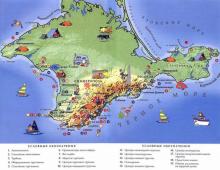
in front of you detailed map Caucasus mountains with names of cities and settlements in Russian. Move the map by holding it with the left mouse button. You can move around the map by clicking on one of the four arrows in the upper left corner.
You can change the scale using the scale on the right side of the map or by turning the mouse wheel.
What country is the Caucasus Mountains in?
Caucasian Mountain is located in Russia. It's wonderful beautiful place with its own history and traditions. Coordinates of the Caucasus Mountains: northern latitude and eastern longitude (show on a large map).
virtual walk
The figurine of a "little man" above the scale will help to make virtual walk in the cities of the Caucasus mountains. By pressing and holding the left mouse button, drag it to any place on the map and you will go for a walk, while inscriptions with the approximate address of the area will appear in the upper left corner. Choose the direction of movement by clicking on the arrows in the center of the screen. The "Satellite" option at the top left allows you to see the relief image of the surface. In the "Map" mode, you will get the opportunity to get acquainted in detail with highways Caucasus mountains and main sights.
antiqus classicus
Caspian mountains
- Caspian mountains
- and gate (Greek Κασπία ὄρη, lat. Caspii monies).
- 1. Panic mountains between Armenia and Albania on the one hand and Media on the other (now Qaradagh, Siah-Koh, i.e. Black and Talysh mountains). In a broad sense, this name means the entire chain of mountains south of the river. Arak (from the Kotur River to the Caspian Sea). Here were the so-called.
Caspian Gate (Caspiapila), a narrow mountain pass 8 Roman miles long and one chariot wide (now the Chamar pass between Narsa-Koh and Siah-Koh). This was the only way from Northwest Asia to the northeastern part of the Persian state, because the Persians blocked this passage with iron gates, which were guarded by guards (claustra Caspiarum).
The Caucasus Mountains are a mountain system between the Black and Caspian Seas.
It is divided into two mountain systems: the Greater Caucasus and the Lesser Caucasus.
The Caucasus is often divided into the North Caucasus and Transcaucasia, the border between which is drawn along the Main, or Watershed, ridge of the Greater Caucasus, which occupies a central position in the mountain system.
The most famous peaks are Mt. Elbrus (5642 m) and Mt.
Kazbek (5033 m) is covered with eternal snow and glaciers.
From the northern foot of the Greater Caucasus to the Kuma-Manych depression, Ciscaucasia extends with vast plains and uplands. To the south of the Greater Caucasus are the Colchis and Kura-Araks lowlands, the Inner Kartli plain and the Alazan-Avtoran valley [the Kura depression, within which the Alazan-Avtoran valley and the Kura-Araks lowland are located]. In the southeastern part of the Caucasus - the Talysh mountains (up to 2492 m high) with the adjacent Lankaran lowland. In the middle and in the west of the southern part of the Caucasus is the Transcaucasian Highlands, which consists of the ranges of the Lesser Caucasus and the Armenian Highlands (Aragats, 4090 m).
The Lesser Caucasus is connected to the Greater Caucasus by the Likhi Ridge, in the west it is separated from it by the Colchis Lowland, in the east by the Kura Depression. The length is about 600 km, the height is up to 3724 m.
Mountains near Sochi - Aishkho (2391 m), Aibga (2509 m), Chigush (3238 m), Pseashkho and others.
Location of the mountain system of the Caucasus Mountains on the world map
(mountain system boundaries are approximate)
Hotels in Adler from 600 rubles per day!
Caucasian mountains or Caucasus- a mountain system between the Black and Caspian Seas with an area of \u200b\u200b~ 477488 m².
The Caucasus is divided into two mountain systems: the Greater Caucasus and the Lesser Caucasus, very often the mountain system is divided into Ciscaucasia (Northern Caucasus), Greater Caucasus and Transcaucasia (South Caucasus). Along the crest of the Main Range, the state border of the Russian Federation with the countries of Transcaucasia passes.
highest peaks
The largest mountain peaks of the Caucasus Mountains (indicators of various sources may vary).
|
Height, in m |
Notes |
|
| Elbrus | 5642 m | highest point Caucasus, Russia and Europe |
| Shkhara | 5201 m | Bezengi, the highest point in Georgia |
| Koshtantau | 5152 m | Bezengi |
| Pushkin Peak | 5100 m | Bezengi |
| Dzhangitau | 5085 m | Bezengi |
| Shkhara | 5201 m | Bezengi, the highest point of Georgia |
| Kazbek | 5034 m | Georgia, Russia (highest point in North Ossetia) |
| Mizhirgi Western | 5025 m | Bezengi |
| Tetnuld | 4974 m | Svaneti |
| Katyn-tau or Adish | 4970 m | Bezengi |
| Shota Rustaveli Peak | 4960 m | Bezengi |
| Gestola | 4860 m | Bezengi |
| Jimara | 4780 m | Georgia, North Ossetia (Russia) |
| Ushba | 4690 m | |
| Tebulosmta | 4493 m | the highest point of Chechnya |
| Bazarduzu | 4485 m | the highest point of Dagestan and Azerbaijan |
| shang | 4451 m | the highest point of Ingushetia |
| Adai-hoh | 4408 m | Ossetia |
| Diklosmta | 4285 m | Chechnya |
| Shahdag | 4243 m | Azerbaijan |
| Tufandag | 4191 m | Azerbaijan |
| Shalbuzdag | 4142 m | Dagestan |
| Aragats | 4094 m | the highest point in Armenia |
| Dombay-Ulgen | 4046 m | Dombai |
| Zilga-Khokh | 3853 m | Georgia, South Ossetia |
| TASS | 3525 m | Russia, Chechen Republic |
| Tsitelikhati | 3026.1 m | South Ossetia |
Climate
The climate of the Caucasus is warm and mild, with the exception of the highlands: at an altitude of 3800 m, the border " eternal ice". In the mountains and foothills there is a large amount of precipitation.
Flora and fauna
The vegetation of the Caucasus is rich in species composition and diversity: oriental beech, Caucasian hornbeam, Caucasian linden, noble chestnut, boxwood, cherry laurel, Pontic rhododendron, some species of oak and maple, wild persimmon, as well as subtropical tea bush and citrus.
In the Caucasus, there are brown Caucasian bears, lynxes, forest cats, foxes, badgers, martens, deer, roe deer, wild boars, bison, chamois, mountain goats (tours), small rodents (forest dormouse, field voles). Birds: magpies, thrushes, cuckoos, jays, wagtails, woodpeckers, owls, owls, starlings, crows, goldfinches, kingfishers, tits, Caucasian black grouse and mountain turkeys, golden eagles and lambs.
Population
More than 50 peoples live in the Caucasus (for example: Avars, Circassians, Chechens, Georgians, Lezgins, Karachais, etc.) which are designated as Caucasian peoples. They speak Caucasian, Indo-European, as well as Altaic languages. Largest cities: Sochi, Tbilisi, Yerevan, Vladikavkaz, Grozny, etc.
Tourism and rest
The Caucasus is visited for recreational purposes: on the shores of the Black Sea there are many sea resorts, The North Caucasus is popular for its balneological resorts.
Rivers of the Caucasus
The rivers originating in the Caucasus belong to the basins of the Black, Caspian and Azov Seas.
- swell
- Kodori
- Ingur (Enguri)
- Rioni
- Kuban
- Podkumok
- Araks
- Liakhva (Big Liakhvi)
- Samur
- Sulak
- Avar Koysu
- andean koisu
- Terek
- Sunzha
- Argun
- Malka (Kura)
- Baksan
- Chegem
- Cherek
Countries and Regions
The following countries and regions are located in the Caucasus.
- Azerbaijan
- Armenia
- Georgia
- Russia: Adygea, Dagestan, Ingushetia, Kabardino-Balkaria, Karachay-Cherkessia, Krasnodar region, North Ossetia-Alania, Stavropol Territory, Chechnya
In addition to these countries and regions, there are partially recognized republics in the Caucasus: Abkhazia, South Ossetia, Nagorno-Karabakh.
The largest cities of the Caucasus
- Vladikavkaz
- Gelendzhik
- Hot key
- Grozny
- Derbent
- Yerevan
- Essentuki
- Zheleznovodsk
- Zugdidi
- Kislovodsk
- Kutaisi
- Krasnodar
- Maykop
- Makhachkala
- Mineral water
- Nazran
- Nalchik
- Novorossiysk
- Pyatigorsk
- Stavropol
- Stepanakert
- Sukhum
- Tbilisi
- Tuapse
- Tskhinvali
- Cherkessk
Cheap flights to Sochi from 3000 rubles.
Where is it located and how to get there
The address: Azerbaijan, Armenia, Georgia, Russia
Geographical position. On a huge isthmus between the Black and Caspian Seas, from the Taman Peninsula to the Apsheron Peninsula, the majestic mountains of the Greater Caucasus are located.
North Caucasus- this is the southernmost part of the Russian territory. The border of the Russian Federation with the countries of Transcaucasia passes along the ridges of the Main, or Dividing, Caucasian Range.
The Caucasus is separated from the Russian Plain by the Kuma-Manych depression, on the site of which a sea strait existed in the Middle Quaternary.
The North Caucasus is an area located on the border of the temperate and subtropical zones.
The epithet "most-most" is often applied to the nature of this territory. Latitudinal zonality is replaced here by vertical zonality. For an inhabitant of the plains, the mountains of the Caucasus are a vivid example of the “multi-story ™” of nature.
Remember where and what is the name of the extreme southern point of Russia.
Features of the nature of the North Caucasus. The Caucasus is a young mountain structure, formed during the period of Alpine folding. The Caucasus includes: Ciscaucasia, Greater Caucasus and Transcaucasia. Only Ciscaucasia and the northern slopes of the Greater Caucasus belong to Russia.

Rice. 92. Orographic scheme of the Caucasus
Often the Greater Caucasus is presented as a single ridge. In fact, it is a system of mountain ranges. From the Black Sea coast to Mount Elbrus is the Western Caucasus, from Elbrus to Kazbek - the Central Caucasus, east of Kazbek to the Caspian Sea - the Eastern Caucasus. In the longitudinal direction, an axial zone is distinguished, occupied by the Vodorazdelny (Main) and Lateral ridges.
The northern slopes of the Greater Caucasus form the Skalisty and Pastbishny ranges. They have a cuesta structure - these are ridges, in which one slope is gentle, and the other is abruptly ending. The reason for the formation of kuest is the interbedding of layers composed of rocks of different hardness.
The chains of the Western Caucasus begin near the Taman Peninsula. At first, these are not even mountains, but hills with soft outlines. They rise as you move east. Mountains Fisht (2867 m) and Oshten (2808 m) - the highest parts of the Western Caucasus - are covered with snowfields and glaciers.
The highest and most grandiose part of the entire mountain system is the Central Caucasus. Here, even the passes reach a height of 3000 m, only one pass - Krestovy on the Georgian Military Highway - lies at an altitude of 2379 m.
The highest peaks are located in the Central Caucasus - the two-headed Elbrus, an extinct volcano, the highest high peak Russia (5642 m), and Kazbek (5033 m).
The eastern part of the Greater Caucasus is mainly the numerous ridges of the mountainous Dagestan (in translation - the Country of Mountains).

Rice. 93. Mount Elbrus
Various tectonic structures took part in the structure of the North Caucasus. In the south there are folded-block mountains and foothills of the Greater Caucasus. It is part of the Alpine geosynclinal zone.
The fluctuations of the earth's crust were accompanied by bending of the earth's layers, their extensions, faults, ruptures. Magma poured out to the surface along the cracks formed from great depths, which led to the formation of numerous ore deposits.
Uplifts in recent geological periods - Neogene and Quaternary - have turned the Greater Caucasus into a mountainous country. The rise in the axial part of the Greater Caucasus was accompanied by an intensive subsidence of earth layers along the edges of the emerging mountain range. This led to the formation of foothill troughs: in the west of the Indolo-Kuban and in the east of the Terek-Caspian.
The complex history of the geological development of the region is the reason for the richness of the bowels of the Caucasus in various minerals. The main wealth of Ciscaucasia is the oil and gas field. Polymetallic ores, tungsten, copper, mercury, and molybdenum are mined in the central part of the Greater Caucasus.
In the mountains and foothills of the North Caucasus, many mineral springs, near which resorts were created that have long gained worldwide fame - Kislovodsk, Mineralnye Vody, Pyatigorsk, Essentuki, Zheleznovodsk, Matsesta. The springs are diverse in chemical composition, in temperature, and extremely useful.

Rice. 94. Geological structure of the North Caucasus
The geographical position of the North Caucasus in the south of the temperate zone determines its mild, warm climate, transitional from temperate to subtropical. Here is a parallel 45 ° N. sh., that is, this territory is equidistant from both the equator and the pole. This situation determines the amount of solar heat received: in summer 17-18 kcal per square centimeter, which is 1.5 times more than the average European part of Russia receives. With the exception of the highlands, the climate in the North Caucasus is mild and warm; on the plains, the average temperature in July exceeds 20 ° C everywhere, and summer lasts from 4.5 to 5.5 months. Average January temperatures range from -10 to +6°C, and winter lasts only two to three months. The city of Sochi is located in the North Caucasus, where the warmest winter in Russia is with a January temperature of +6.1 ° С.
On the map, determine whether there are any obstacles in the foothills of the North Caucasus in the way of arctic air masses, tropical. What atmospheric fronts pass near this area? Analyze on maps how precipitation is distributed in the North Caucasus, explain the reasons for this distribution.
The abundance of heat and light allows the vegetation of the North Caucasus to develop in the north of the region for seven months, in Ciscaucasia - eight, and on the Black Sea coast, south of Gelendzhik - up to 11 months. This means that with the appropriate selection of crops, two crops per year can be obtained here.
The North Caucasus is distinguished by a very complex circulation of various air masses. Various air masses can penetrate into this area.
The main source of moisture for the North Caucasus is Atlantic Ocean. Therefore, the western regions of the North Caucasus are characterized by a large amount of precipitation. The annual amount of precipitation in the foothill areas in the west is 380-520 mm, and in the east, in the Caspian Sea, - 220-250 mm. Therefore, in the east of the region there are often droughts and dry winds. However, they are often accompanied by dusty, or black, storms. Storms occur in the spring, when the top layers of dry soil, still loosely held together by newly emerged plants, are blown away by strong winds. A cloud of dust rises into the air, covering the sky and the sun.
Measures to combat black storms are properly planned forest shelterbelts and high agricultural technology. However, until now, due to black storms, it is necessary to resow (re-sow) several tens of thousands of hectares, from which the most fertile soil layer is demolished during dust storms.
The climate of the highlands very different from the plains and foothills. The first main difference is that much more precipitation falls in the mountains: at an altitude of 2000 m - 2500-2600 mm per year. This is due to the fact that the mountains trap air masses, forcing them to rise up. At the same time, the air cools and gives off its moisture.
The second difference in the climate of the highlands is a decrease in the duration of the warm season due to a decrease in air temperature with height. Already at an altitude of 2700 m on the northern slopes and at an altitude of 3800 m in the Central Caucasus there is a snow line, or the border of "eternal ice". At an altitude of over 4000 m, even in July, positive temperatures are very rare.
Remember how much the air temperature decreases when you rise for every 100 m. Calculate how much the air will cool when you rise to a height of 4000 m, if its temperature at the earth's surface is +20 ° С. What happens to the moisture in the air?
In the mountains of the Western Caucasus, due to the abundance of precipitation, a four to five meter layer of snow accumulates during winter, and in mountain valleys where it is blown away by the wind - up to 10-12 m. The abundance of snow in winter leads to the formation of avalanches. Sometimes one awkward movement, even a sharp sound, is enough for a thousand-ton mass of snow to fly down a steep ledge, destroying everything in its path.
Explain why there are practically no avalanches in the mountains of the Eastern Caucasus.
Think about what differences will be observed in the change of altitudinal zones on the western and eastern slopes.
The third difference of the alpine climate is its amazing diversity from place to place in connection with the height of the mountains, the exposure of the slope, proximity or distance from the sea.
The fourth difference is the peculiarity of atmospheric circulation. Cooled air from the highlands rushes down the comparatively narrow intermountain valleys. For every 100 m lowered, the air heats up by about 1°C. Descending from a height of 2500 m, it heats up by 25 ° C and becomes warm, even hot. This is how the local wind - foehn is formed. Hair dryers are especially frequent in spring, when the intensity of the general circulation of air masses increases sharply. Unlike a hair dryer, when masses of dense cold air invade, a bora is formed (from the Greek boreas - north, North wind), a strong cold downwind wind. Flowing over low ridges into an area with warmer rarefied air, it heats up relatively little and “falls” down the leeward slope at high speed. Bora is observed mainly in winter, where the mountain range borders on the sea or a vast body of water. The Novorossiysk Bora is widely known (Fig. 95). And yet, the leading factor in climate formation in the mountains, which greatly affects all other components of nature, is the height, which leads to vertical zonality of both climate and natural zones.

Rice. 95. Scheme of formation of the Novorossiysk bora
The rivers of the North Caucasus are numerous and, like the relief and climate, are clearly divided into flat and mountainous. Stormy mountain rivers are especially numerous, the main source of food for which is snow and glaciers during the melting period. The largest rivers are the Kuban and the Terek with their numerous tributaries, as well as the Bolshoi Egorlyk and Kalaus, which originate in the Stavropol Upland. In the lower reaches of the Kuban and the Terek there are floodplains - vast swampy areas covered with reeds and reeds.

Rice. 96. Altitudinal zonality of the Greater Caucasus
The wealth of the Caucasus is fertile soil. In the western part of Ciscaucasia, chernozems predominate, and in the eastern, more arid part, chestnut soils. The soils of the Black Sea coast are intensively used for orchards, berry fields, and vineyards. The northernmost tea plantations in the world are located in the Sochi region.
In the mountains of the Greater Caucasus, altitudinal zonation is clearly expressed. The lower belt is occupied by broad-leaved forests dominated by oak. Above are beech forests, which with height pass first into mixed, and then into spruce-fir forests. The upper border of the forest is located at an altitude of 2000-2200 m. Behind it, on mountain-meadow soils, there are lush subalpine meadows with thickets of Caucasian rhododendron. They pass into short-grass alpine meadows, followed by the highest belt of snowfields and glaciers.
Questions and tasks
- On the example of the North Caucasus, show the influence geographical location territory on the features of its nature.
- Tell us about the formation of the modern relief of the Greater Caucasus.
- On the contour map designate the main geographical objects of the region, mineral deposits.
- Give a description of the climate of the Greater Caucasus, explain how the climate of the foothills differs from the highlands.
In the ridge of the Caucasus Mountains is Elbrus. It is also considered the whole of Europe. Its location is such that several peoples live around it, who call it differently. Therefore, if you hear such names as Alberis, Oshkhomakho, Mingitau or Yalbuz, know that they mean the same thing.
In this article, we will introduce you closer to the most high mountain in the Caucasus - Elbrus, which was once active volcano, and occupying the fifth place on the planet, among the mountains formed in the same way.
The height of the Elbrus peaks in the Caucasus
As already mentioned, the highest mountain in Russia is an extinct volcano. This is precisely the reason why its top does not have a pointed shape, but looks like a two-peak cone, between which there is a saddle at an altitude of 5 km 200 m. Two peaks located at a distance of 3 km from each other are different: the eastern one is 5621 m, and the western one is 5642 m. The reference always indicates a great value.
Like all former volcanoes, Elbrus consists of two parts: a rock pedestal, in this case it is 700 m, and an artificial cone formed after eruptions (1942 m).
Starting from a height of 3500 m, the surface of the mountain is covered with snow. First, mixed with scatterings of stones, and then turning into a uniform white cover. The most famous Elbrus glaciers are Terskop, Big and Small Azau.
The temperature at the top of Elbrus practically does not change and is -1.4°C. A large amount of precipitation falls here, but due to such a temperature regime, it is almost always snow, so the glaciers do not melt. Since the snow cap of Elbrus is visible all year round for many kilometers, the mountain is also called "Little Antakrtida".

The glaciers located at the top of the mountain feed the most big rivers these places - Kuban and Terek.
Climbing ElbrusTo see the beautiful view from the top of Elbrus, you need to climb it. It is quite simple to do this, since you can get to a height of 3750 m along the southern slope on a pendulum or chairlift. cable car. Here is a shelter for travelers "Barrels". It consists of 12 insulated trailers for 6 people and a stationary kitchen. They are equipped so that they can wait out any bad weather, even for a long time.
The next stop is usually made at an altitude of 4100 m in the Shelter of Eleven Hotel. The parking lot here was established in the 20th century, but was destroyed by fire. Then a new building was built in its place.
For the first time, the peaks of Elbrus were conquered in 1829 on the east and in 1874 on the west.

Now the Donguzorun and Ushba massifs, as well as the Adylsu, Adyrsu and Shkheldy gorges are popular with climbers. Increasingly, mass ascents to the peaks are organized. Located on the south side ski resort Elbrus Azau. It consists of 7 tracks, with a total length of 11 km. They are suitable for both beginners and advanced skiers. A distinctive black of this resort is freedom of movement. On all routes there is a minimum number of fences and dividers. It is recommended to visit it from October to May during this period there is the strongest snow.

Elbrus, at the same time, is a very beautiful and dangerous mountain. Indeed, according to scientists, there is a possibility that in the next 100 years the volcano will wake up, and then all nearby regions (Kabardino-Balkaria and Karachay-Cherkessia) will suffer.